

| Before you start: | Use case Location: | Uses GIS data: | Authors: |
|---|---|---|---|
| General use case, no particular location | No | Mark Brussel |
Introduction:
This use case provides a number of examples of how functions of space can be combined in order to reduce flood hazard. These examples are taken from different parts of the world and are discussed with a view to possible application on the Eastern Caribbean islands in the CHARIM project.
Objectives:
- Provide an overview of possible combinations of functions of space that can reduce flood risk
- Discuss their potential application in the Caribbean islands.
Flowchart:
No flowchart applies
Problems definition and specifications:
In land use planning, spaces are generally developed to facilitate one function, or activity. However, possibilities may exist to combine different functions in one location. This combination of functions could be continuous, or, as will be mostly the case, sequential. In the latter case the area will have a particular function most of the time, e.g. a sports facility, but in a given circumstance, e.g. a flood event, the function can change, e.g. into a storage facility.
This concept of multiple functions has been often applied with regards to green infrastructure and green spaces. Multifunctional green spaces may act as agriculture, forests, or parks and recreation areas, next to other environmental functions, increase infiltration, but may also act as water storage, and provide additional storage space in case of flooding.
Developing concepts of multifunctional use of space requires planners, engineers, environmentalists and various stakeholders such as government and local residents to work together to deliver effective and lasting contributions to reduce flood risk.
In this use case a number of examples of combined functions are presented and their potential application to the islands of the Eastern Caribbean discussed.
Analysis steps:
Use of green infrastructure for flood risk reduction
In the Caribbean islands, the topography and the limited amount of available flat terrain, in combination with increasing land pressure and a lack of planning controls have put pressure on floodplains, where most of the development occurs. There is often insufficient space for rivers and in many locations developments are at risk of flooding. On a number of islands structural works are ongoing to strengthen river banks, and construct and repair bridges and culverts, however little attention seems to be paid to green infrastructure.
Whereas traditionally flooding in urbanized catchments has been mitigated by canalization of rivers, we see an international trend now towards un-engineered rivers and the implementation of multi-functional green infrastructure. In the Caribbean islands there may be difficulties to provide more space to rivers at the downstream end of floodplains, as these are highly built up and difficult to reorder, however, there may be scope for green infrastructure to contribute to reduced flood hazards, particularly when it is implemented in a multifunctional manner. In addition, green infrastructure has tremendous water quality advantages as direct discharge of pollutants in rivers and sea is reduced and local treatment can more easily be provided.
With green infrastructure we refer to a broad category of measures such as parks, woodland, private gardens, street trees, green roofs and rainwater harvesting, but also wetlands, ponds and temporary flood storage areas. Hydrologically, the implementation of green infrastructure will lead to higher infiltration, storage, interception and evapotranspiration, and thereby lead to a reduction of runoff volume, a lower peak discharge (which is fundamental in engineering design of drainage and flood control structures) and a postponement of the time of peak flow. This is illustrated in the figure below, where a flattening of the hydrograph can be seen as a result of increased storage. Although multifunctional green infrastructure obviously requires investments, these can be offset against the savings that will occur because other elements of flood management infrastructure can be developed at lower cost.
Below a number of potential measures are shown. It may be that a combination of measures, such as those discussed below, is necessary. Which measure or combination of measures is most appropriate depends on the local situation in each catchment. Local level analysis and modeling needs to be carried out to evaluate the extent to which each of the potential measures reduces flood hazard, and only the most promising measures may be chosen.
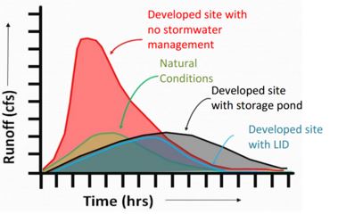
Figure 1: Effect of local site storage on runoff. LID stands for Low Impact Development. (Source: Horsley Witten Group, Inc. and Center for Watershed Protection, Inc., 2014.)
Green roofs
Roof vegetation can contribute to increase evapotranspiration and water storage and slow down the runoff process. It is a solution that is relatively simple to implement in case the predominant way of construction is buildings with flat roofs, as is often the case in the Caribbean islands. Depending on the location of these buildings in the catchment and the rainfall characteristics, green roofs can help flatten the discharge peak and thus decrease flood hazard. The vegetation may also help to keep the house cool, thus considerably reducing money spent on air conditioning, and contribute to an attractive green environment and possibly to agricultural produce such as vegetables and herbs. Obviously the built quality of the roof, preferably in reinforced concrete, needs to be such that the additional force of the vegetation and water can be accommodated within safety margins.
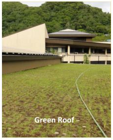
Figure 2: Green roof of EPA office in SAMOA. Source: Horsley Witten Group, Inc. and Center for Watershed Protection, Inc
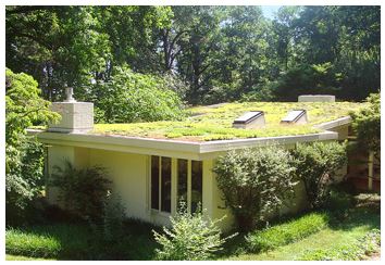
Figure 3: A local green roof solution. (Source: http://www.caribbeanlandandproperty.com)
Permeable pavements
The construction of open and permeable pavements is meant to reduce runoff by increasing infiltration and percolation. Built up areas consist of a lot of hard and highly impermeable surfaces. This situation increases runoff volumes, runoff peaks and also shortens the time before the peak of the runoff is reached. Permeable pavements reduce runoff and thereby contribute to a reduction of flood water levels. Useful application of such principle in the Caribbean would depend on a number of factors. Slopes would need to be modest, as water speeds on speed slopes are such that little infiltration will take place unless special measures such as iron rosters are taken. In particular parking spaces near shopping locations and in residential areas can be useful locations for the location of permeable surfaces. Below some pictures of permeable pavements are shown.
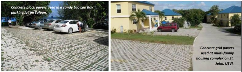
Figure 4: Examples of permeable pavements (Source: Horsley Witten Group, Inc. and Center for Watershed Protection, Inc)
Rainwater harvesting with water tanks
Water tanks, connected to the roof of a building and/or collecting rainwater from a particular plot of land are useful local water storage solutions that may help reduce runoff and flood hazard. In addition, they may have a number of other functions such as providing water for local irrigation and gardening, the washing of cars, or other uses. If water is to be up to drinking water quality standard provisions for purification need to be installed. The main principle of rainwater harvesting with below ground and above ground storage is shown in the following picture.
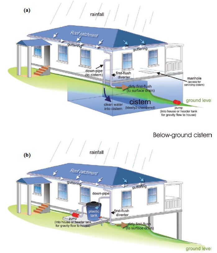
Figure 5: Typical domestic rainwater harvesting systems (Source: UNEP and CEHI, 2009)
Retention basins
Retention basins with multiple functions can be a useful and efficient way to increase water storage and reduce flood hazard. Retention basins are particularly suited in more agricultural sections of a catchment, as there is more space for construction. Retention basins can function irrespective of their location in the catchment (lower, middle, or upper), as they will contribute to reduce runoff volume and to flatten the runoff peak. Detailed model studies are needed to evaluate the contribution of a particular retention basin. Typically these basins are agricultural or livestock areas that can be made suitable for retention by the construction of levees and a water intake structure that allows them to be filled in case of a flood.
Parks and sports grounds are also particularly suited to increase infiltration and evapotranspiration and when constructed with a water retention function, also water storage. As these areas often have a large size, they can contribute significantly to reduce flood hazard. Storage for these areas can be increased when they are deepened - provided that a pump system is installed that can pump the area dry after the flood - or when they are already mostly closed facilities like sport stadiums can be closed entirely and filled using pumps. They may be constructed in such a way that they start to function when river water levels are above a certain height.
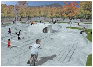
Figure 6: Playground with water storage function (Source: Municipality of Rotterdam)
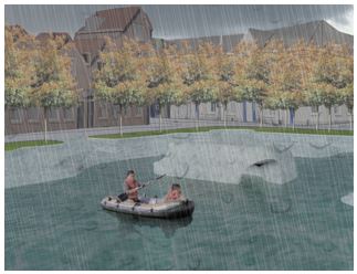
Figure 7: Playground in a situation of heavy rain
River bypasses
River bypasses may be constructed to be able to reduce flood water levels in the case of flooding. These may be constructed in such a way that only after a certain flood level is reached the bypass channel will be in operation. This will allow it to be used for other purposes during the rest of the time, e.g. agriculture, grazing, but also as a ground for sports, fairs, etc. and possibly as car park. Examples of large scale bypasses can be found in the currently ongoing "room for the river" project in the Netherlands, where bypasses are constructed in the main river system. Although this is done at a different scale, the concept may be useful on some of the islands in the Caribbean, as it specifically designates an area with a mix of functions, allowing it to perform a useful function for most of the year, but not allowing structural and permanent use, such as residential buildings. In combination with a warning system (in the Caribbean probably a weather warning system) this will allow for all people to leave and authorities to clear the area before flood levels have risen to a degree that the bypass channel will be used. An example of a large scale river bypass is the Kampen bypass in the Netherlands that is currently under construction, however, the concept may be equally useful for small scale solutions.
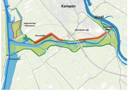
Figure 8: River bypass Kampen with mixed functions of nature area, recreation and flood protection
Multi functional flood defenses
Structural solutions like flood defenses can themselves be made multi-functional, allowing for a more economic use of space, or as described in the report Floodprobe by Deltares et. al. (2013):
"Multifunctional Flood Defenses are flood defenses that combine the function of flood protection with other functions. In addition to flood protection, multi-functional flood protection fulfills functions like housing, recreation and leisure, commercial buildings, ecology, mobility and transport, underground infrastructure and is a functional part of the urban or rural environment."
As such, multifunctional flood defenses therefore do not combine functions to reduce flood risk, flood risk is reduced through the flood defense structure itself, but they make this structure more functional, feasible and efficient.
Examples of such combinations of functions as taken from the Floodprobe report are given below:
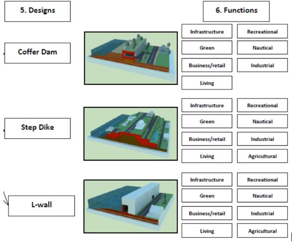
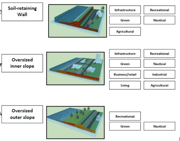
Figure 9: Overview of multifunctional flood defense designs and functions (Source: Deltares et. al., 2013)
Whether these type of flood defenses hold promise for implementation on the Eastern Caribbean islands is a matter of discussion. For primary flood defenses that protect against see intrusion, there may be possibilities to combine functions as per local requirements. For river protection, additional possibilities may exist. Probably the execution of such ideas would not be as capital intensive as some of the examples provided above that are more geared to large urban centers with higher space pressures, however, possibly locally attractive solutions of combining various functions can be found, which would result in a better use of space in the relatively densely built up and narrow flood plains on some of the islands.
Conclusions:
It can be advantageous to combine various functions in a location with a flood hazard reduction function. Generally, in order for flood hazard to be reduced considerably, multiple solutions may be needed, depending on the locations. As the islands in the Eastern Caribbean have little space available, MFUS solutions may offer important benefits over more traditional flood mitigation measures. The examples given merely provide directions for thought, whether their application is useful in the local context needs to be evaluated on a case by case basis.
The evaluation of MFUS type solutions can be traded off against other solutions, such as more traditional flood mitigation measures and planning instruments such as relocation. Useful methods that can be used in this process are Multi-Criteria Evaluation and Cost benefit analysis, which may help to provide guidance as to which initiative is most suited to be implemented locally.
References:
Deltares, Dura Vermeer. 2013. Design concepts of multifunctional flood defence structures. EU Floodprobe.
Horsley Witten Group, Inc. and Center for Watershed Protection, Inc.,2014. Stormwater Management in Pacific and Caribbean Islands: A Practitioner’s Guide to Implementing LID.
UNEP and CEHI, 2009. Handbook for Rainwater Harvesting for the Caribbean. United Nations Environment Programme, Nairobi, Kenya. Caribbean Environmental Health Institute, Castries, St. Lucia. (http://www.caribank.org/uploads/2013/08/em-rainwater-handbook-caribbean.pdf accessed April 10 2016).