

This section introduces the term landslide, and provides information on landslide types and processes and useful resources on landslides for engineers and planners.
Keywords:
landslides, mass movements, classification, examples.
|
Author |
Links |
|---|---|
|
Cees van Westen |
|
What is a landslide?
In literature a wide variety of names have been used for the process whereby soil or rock is displaced along the slope by mainly gravitational forces. The most frequently used are: Slope movement; Mass movement; Mass wasting; Landslide. In the last decades landslide is the term most used, though in the narrow sense of the word it only indicates a specific type of slope movement with a specific composition, form and speed. In a general sense the term landslide is defined as the movement of a mass of rock, debris or earth down the slope (Cruden, 1991). The term landslide is a container term that includes many types and processes that are quite different but that have in common that the movement takes place under the influence of gravity.
Figure 1: Schematic illustration of the forces acting on a slope and the ratio of shear strength and shear stress that determine the Factor of Safety. Click to start presentation
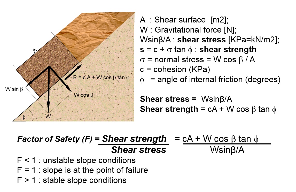
This is the very basic equation, which doesn't take many additional factors into account such as the effect of soil moisture, groundwater table, differences in material types, and seismic acceleration. Basically, slopes become unstable when one of the two components changes, as shown in table 1.
Table 1: Major contributing factors to instability.
|
Increase of shear stress |
Decrease of material strength |
|---|---|
|
Removal of lateral and underlying support (erosion, previous slides, movement of adjacent areas, road cuts and quarries) |
A decrease of material strength (weathering, change in state of consistency) |
|
An increase of load (weight of rain/snow, fills, vegetation, buildings) |
Changes in intergranular forces (pore water pressure, solution) |
|
An increase of lateral pressures (hydraulic pressures, roots, crystallization, swelling of clay) |
Changes in material structure (decrease of the strength of the failure plane, fracturing due to unloading) |
|
Transitory stresses (earthquakes, vibrations of trucks, machinery, blasting) |
|
|
Regional tilting (geological movements) |
The overall component of forces, linked with slope morphology and geotechnical parameters of the material, defines the specific type of landslide that may occur. The potential causes of landslide can be subdivided into geological causes, morphological causes, physical causes, and human causes. Landslides can also be seen as controlled by internal factors that make the slope favourable to instability and triggering factors that actually trigger the landslide to happen.
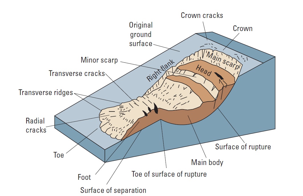
Landslide are characterized by a number of diagnositic features which are summarized in Figure 2. (from Highland and Bobrowski, 2008)
Figure 2: A simple illustration of a rotational landslide that has evolved into an earthflow. Image illustrates commonly used labels for the parts of a landslide (from Varnes, 1978, highland and Bobrowski, 2008)
Landslide impact
Data on landslide impacts is difficult to obtain. In the international databases, such as EM-DAT (CRED, Louvain) landslides are highly underrepresented due to the inclusion criteria of 10 or more persons killed or 100 or more affected. See also Data Management Book, section 4.2. Also because landslides are often grouped under the main triggering events, such as hurricanes or earthquakes.
Table 2: Results from EMDAT data base on landslide impact for the Caribbean. These data underestimate landslide impact enormously, due to exclusion of events with less than 10 fatalities or 100 affected, and the inclusion of landslide impact in those of the triggering events (mostly Storms).
|
Country |
Fatalities |
Affected |
Injured |
Homeless |
Total_affected |
|---|---|---|---|---|---|
|
Haiti |
262 |
0 |
60 |
1000 |
1060 |
|
Jamaica |
93 |
0 |
0 |
0 |
0 |
|
Puerto Rico |
126 |
0 |
0 |
0 |
0 |
|
Saint Lucia |
0 |
175 |
0 |
0 |
175 |
|
Trinidad and Tobago |
2 |
1200 |
0 |
0 |
1200 |
Petley (2012) has compiled an international landslide fatalities database for the period since 2004. Other attempts were made by Nadim et al. (2006) and by Kirschbaum et al. (2010, 2015) who produced and analyzed a global catalog for rainfall-induced landslides. On a global basis, Petley (2012) compiled a database of landslides that caused loss of life for the period 2004 to 2010, demonstrating that losses were considerably higher than had been previously considered. In the latter studies, a number of hotspots of landslide activity were identified, most notably in parts of China, South Asia, Southeast Asia, the Caribbean, Central America and South America. Sepulveda and Petley (2015) analyzed the distribution of fatal landslides and landslide fatalities in the Caribbean, Central and South America in more detail. They provide a bit more information on landslide fatalities for the Caribbean. However, these data are still far from complete. Therefore we carried out a more detailed analysis for the countries of Dominica, Saint Lucia, Saint Vincent and Grenada which is presented in section 2.1 (Analysis of historical events).
Figure 3: Spatial distribution of fatal landslides. Each dot represents a single landslide (Petley, 2012)
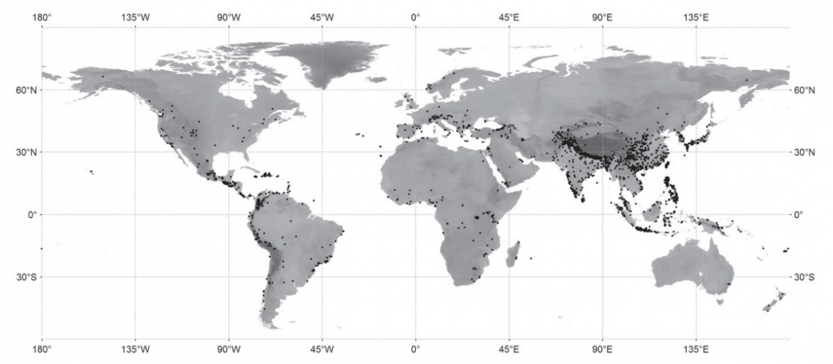
Table 3: Fatal landslides, fatalities, population and population density for a number of Caribbean countries (Sepulveda and Petley, 2015)
|
Caribbean country |
Fatal landslides 2004-2013 |
Fatalities 2004-2013 |
Population (thousands) |
Population density (people/km2) |
|---|---|---|---|---|
|
Dominica Dominican Republic Grenada Haiti Jamaica Puerto Rico St Lucia 1 5 St Vincent and the Grenadines Trinidad and Tobago |
1 11 1 33 10 2 1 4 9 |
3 48 1 4529 20 2 5 9 12 |
71.2 10 016.8 104.7 9896.4 2741.5 3709.7 177.4 109.3 1328.1 |
94.8 206.5 304.3 356.6 249.4 418.0 329.1 281.7 258.9 |
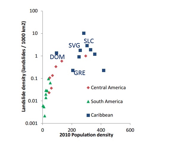
Figure 4: Landslide density versus population density per country (Sepulveda and Petley, 2015), with indication of Dominca (DOM), Saint Lucia (SLC), Saint Vincent (SVG) and Grenada (GRE)
Landslide classification
The most important classification of landslides was made by Varnes in 1978, and is based on a combination of the type of movement and material type. This was adapted in a new classification of Cruden and Varnes (1996). It nominates primarily type of movement, and secondarily type of material. Factors as activity and movement type, and depth can be added as an adjective to the classification name. For example a moderately rapid, shallow, moist, active, single translational soil slide. This classification was adopted by the IAEG Commission UNESCO Working Party on World Landslide Inventory (Cruden, 1993; Cruden and Varnes, 1996).
Figure 5: Landslide classification according to Varnes (1978)
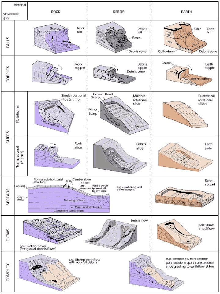
Table 4: Landslide classification according to Cruden and Varnes (1996)
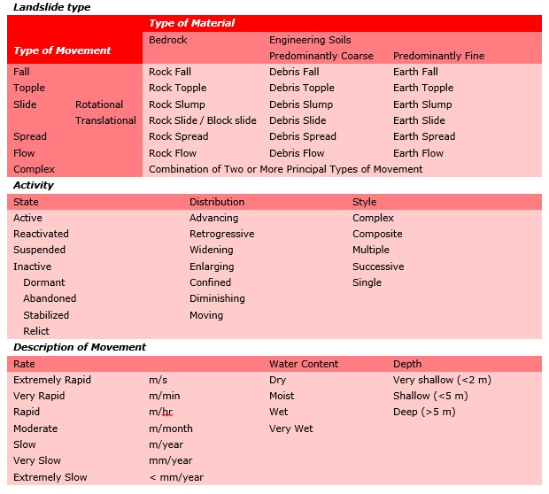
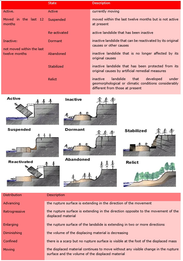
Table 5: Landslide activity classification according to Cruden and Varnes (1996)
Useful resources on landslides
| The Landslide Handbook - A Guide to Understanding Landslides. L. M. Highland, United States Geological Survey, and P. Bobrowsky, Geological Survey of Canada | |
|
This handbook is intended to be a resource for people affected by landslides to acquire further knowledge, especially about the conditions that are unique to their neighbourhoods and communities. Considerable literature and research are available concerning landslides, but unfortunately little of it is synthesized and integrated to address the geographically unique geologic and climatic conditions around the globe. This handbook aims to help homeowners, community and emergency managers, and decision makers to take the positive step of encouraging awareness of available options and recourse in regard to landslide hazard. The handbook provides a list of references that can be used for further knowledge about landslides. The handbook is intended for use by managers and decision makers in communities so that the information will be disseminated by such officials to other members of those communities. |
 |
| This book has two main aims: to demonstrate to international development agencies, governments, policy makers, project managers, practitioners, and community residents that landslide hazard can often be reduced in vulnerable urban communities in the developing world, and to provide practical guidance for those in charge of delivering Management of Slope Stability in Communities (MoSSaiC) on the ground. The purpose of the book is to take readers into the most vulnerable communities in order to understand and address rainfall-triggered landslide hazards in these areas. Community residents are not just seen as those at risk, but as the people with the best practical knowledge of the slopes in their neighbourhood. As used here, 'community based' means engaging and working with communities to find and deliver solutions to landslide risk together. This approach leads governments to develop new practices and policies for tackling landslide risk. This book standardizes those elements of MoSSaiC that have led to its successful implementation in the Eastern Caribbean, and that are essential to the overall objectives (such as community engagement, mapping localized slope features, and broad drainage design principles). The book's nine chapters provide guidance to project managers and practitioners on the entire end-to-end process of community-based landslide risk reduction. While certain chapters are more directly relevant to one audience than another, it is helpful for all audiences to read the 'getting started' section of each chapter and be alerted to the nine project milestones. |  |
| Recommendations for the quantitative assessment of landslide risk. J. Corominas et al. | |
| This guideline presents recommended methodologies for the quantitative assessment of the landslide hazard, vulnerability and risk at different scales (site specific, local, regional and national), as well as for the verification and validation of the results. The methodologies described focus on the evaluation of the probability of occurrence of different landslide types with certain characteristics. Methods to determine the spatial distribution of landslide intensity, the characterisation of the elements at risk, the assessment of the potential degree of damage and the quantification of the vulnerability of the elements at risk, and the quantitative risk assessment (QRA) are also described. The guidelines are intended to be used by scientists and practising engineers, geologists and other landslide experts. |  |
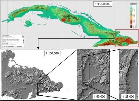
| Multi-scale landslide risk assessment in Cuba. PhD thesis E. Castellanos, ITC, The Netherlands | |
|
This PhD research thesis presents a methodology and its implementation for spatial landslide risk assessment in Cuba, using a multi-scale approach at national, provincial, municipal and local level. At the national level a landslide risk index was generated, using a semiquantitative model with 10 indicator maps using spatial multi-criteria evaluation techniques in a GIS system. The hazard assessment at the provincial scale was carried out by combining heuristic and statistical landslide susceptibility assessment, its conversion into hazard, and the combination with elements at risk data for vulnerability and risk assessment. At the municipal scale a detailed geomorphological mapping formed the basis of the landslide susceptibility assessment. At the local level, digital photogrammetry and geophysical surveys were used to characterize the volume and failure mechanism of a single landslide at 1:10,000 scale. This work can be seen as a good example of what can be achieved in a Caribbean area, with data limitations. |
 |
|
A Guide for Management of Landslide-Prone Terrain in the Pacific Northwest |
|
| A Guide for Management of Landslide-Prone Terrain in the Pacific Northwest has been prepared for agency and industry personnel who are operating in areas with existing or potential stability problems. The document is intended for use in the coastal areas of the Pacific Northwest, even though the principles may be applicable to other locations in North America. The guide addresses four topics: Slope movement processes and characteristics, An office/field technique for recognizing landslide-prone terrain, Measures to manage unstable terrain during forestry activities, Road deactivation and revegetation of unstable terrain. The guide is designed to be carried in field staff vehicles. A "condensed" version of the book will be available in the form of field cards that can be more easily carried in field note books. They will provide some of the basic information contained in this larger document. |  |
|
Planning for Natural Hazards: Oregon Technical Resource GuideSource: Landslides |
|
| The purpose of this project was to develop, with the assistance of the Department of Land Conservation and Development and other Oregon state agencies, technical resource guides (TRGs) for Oregon cities and counties to plan for, and limit the effects of, threats posed by natural hazards. The project intended to provide resource guides and plan evaluation tools, written for local staff and officials to assist jurisdictions across the state in developing policies, plans, and non-regulatory mitigation strategies to prevent high-risk development and to understand the legal ramifications of regulating development in potential hazard areas. |  |
| US Army Corps Of Engineers. Engineer Manual: Slope Stability | |
|
This engineer manual (EM) provides guidance for analyzing the static stability of slopes of earth and rock-fill dams, slopes of other types of embankments, excavated slopes, and natural slopes in soil and soft rock. Methods for analysis of slope stability are described and are illustrated by examples in the appendixes. Criteria are presented for strength tests, analysis conditions, and factors of safety. The criteria in this EM are to be used with methods of stability analysis that satisfy all conditions of equilibrium. Methods that do not satisfy all conditions of equilibrium may involve significant inaccuracies and should be used only under the restricted conditions described herein. |
 |
| Eco-system based Landslide Risk Reduction | |
| In 2013, the United Nations Environmental Programme (UNEP) and Center for Natural Resources and Development (CNRD) based at the Cologne University for Applied Sciences (CUAS), Germany jointly developed a master's module "Disasters, Ecosystems and Risk Reduction", which is currently being implemented in a number of universities around the world. The current format of the course is designed for masters students enrolled in a regular university and provides lecturers with the necessary teaching materials and a sophisticated didactic concept. The instructors' manual is available online and interested universities have open access to all materials (available online) |  |
Examples of videos related to landslides:
- https://www.youtube.com/watch?v=Vd7eHG2b_tQ&ab_channel=JansonMedia
- https://www.youtube.com/watch?v=sQjbBOKtah0&ab_channel=TopDocumentaryFilmsChannel
- https://www.youtube.com/watch?v=G7qpzPQM2uM&ab_channel=ScienceTube
- https://www.youtube.com/watch?v=2-e2JjktQ6A&ab_channel=ocweb
References
Cruden, D.M, and Varnes, D.J., 1996, Landslide types and processes, in Turner, A. Keith, and Schuster, Robert L. eds. Landslides-Investigation and mitigation: Transportation Research Board, Special report no. 247, National Research Council, National Academy Press, Washington, D.C., p. 36-75.
Cruden, D.M., 1993, The multilingual landslide glossary: Richmond., British Columbia, Canada, Bitech Publishers,for the UNESCO Working Party on World Landslide Inventory, 1993
Guzzetti, F.: Landslide fatalities and the evaluation of landslide risk in Italy, Engin. Geol., 58, 89-107, 2000.
Guzzetti, F., Stark, C. P., and Salvati, P.: Evaluation of flooed and landslide risk to the population of Italy, Environ. Manage., 36, 15-36, 2005.
Highland, L.M., and Bobrowsky, Peter, 2008, The landslide handbook-A guide to understanding landslides: Reston, Virginia, U.S. Geological Survey Circular 1325, 129 p., 2008)
Kirschbaum, D. B., Adler, R., Hong, Y., Hill, S., and Lerner-Lam, A. A.: global landslide catalog for hazard implications: method, results, and limitations, Nat. Hazards, 52, 561-575, 2010.
Kirschbaum, D. B., Stanley, T., and Zhou, Y. Spatial and temporal analysis of a global landslide catalog, Geomorphology, in press, doi:10.1016/j.geomorph.2015.03.016, 2015.
Nadim, F., Kjekstad, O., Peduzzi, P., Herold, C., and Jaedicke, C.: Global landslide and avalanche hotspots, Landslides, 3, 159-173, 2006
Petley, D. N.: Global patterns of loss of life from landslides, Geology, 40, 927-930, 2012
Sepulveda, S.A. and Petley, D.N. (2015) Regional trends and controlling factors of fatal landslides in Latin America and the Caribbean. Nat. Hazards Earth Syst. Sci., 15, 1821-1833, 2015
http://www.nat-hazards-earth-syst-sci.net/15/1821/2015/nhess-15-1821-2015.pdf
Soeters R., and van Westen, C.J., 1996, Slope instability recognition, analysis, and zonation, in Turner, A.K.,and Schuster, R.L. eds., Landslides-Investigation and mitigation: Transportation Research Board Special Report 247, National Research Council, Washington, D.C., p. 129-177
Varnes, D.J., 1978, Slope movement types and processes, in Schuster, R.L., and Krizek, R.J., eds., Landslides- Analysis and control: Transportation Research Board Special Report 176, National Research Council, Washington, D.C., p. 11-23