

This introductory section on spatial planning is composed of text and illustrations adapted from Sliuzas, 2004 and Alam, 2015, supplemented with new materials
Keywords: spatial planning; physical planning
Authors: Richard Sliuzas, Mark Brussel, Mujeeb Alam
Links:
- Legislation and spatial planning in Belize
- Legislation and spatial planning in Dominica
- Legislation and spatial planning in Saint Lucia
- Legislation and spatial planning in Saint Vincent and the Grenadines
- Legislation and spatial planning in Grenada
- Use case national planning
- Use case local planning
A brief introduction to spatial planning in theory and practice
Spatial planning is a future oriented activity. The compendium of European spatial planning refers to spatial planning as methods used by the national and local governments to influence the future allocation of activities in space (Nadin et al, 1997). Typically it is a public sector activity with both regulatory and development functions (United Nations Economic Commission for Europe, 2008). Through spatial planning individuals and collective agents exercise discretion and make choices or decisions about future courses of action that are related to future investments in spatial development for one or more administrative units. Such choices relate to questions such as: What type of development, if any, should take place in a given location; when should the developments take place, etc.? These choices imply that the stakeholders or actors in the planning process have a shared understanding of the issues at hand, of the need for action, of the desired spatial outcomes and that the actors collectively have the means to reach their goals; in many countries and localities such matters may be questionable in practice. As many of the issues being considered are shrouded in uncertainty, the making of spatial plans entails many wicked problems.
One of the key issues that should be considered in all spatial planning activities is disaster risk reduction (DRR). Spatial planning is recognized by UNISDR (www.unisdr.org) as a field that has the potential to contribute greatly to the creation of settlements and cities with lower disaster risk. Broadly speaking spatial planning can contribute to DRR in a number of ways: by separating new sensitive land uses (residential areas, schools, etc.) from hazardous locations; by relocating existing sensitive land uses from locations where they are exposed to excessive hazard levels; by initiating improvement programs designed to improve the quality and durability of existing structures and infrastructures; by ensuring that new building and planning codes include DRR provisions and standards and that these are properly implemented and enforced.
Multi-level spatial planning
Spatial planning may be undertaken at different spatial levels e.g. National and Local in the case of the CHARIM project (see Use case book 2 for examples of National and Local land use planning). Each level has a different level of detail and to some extent even the issues being dealt with may differ. It is quite common for example that National level plans are quite broad in focus and highly generalized in spatial terms. Broad brush, highly conceptual maps may be one of the outcomes of national level planning that provides guidance for local level actors but which may not be legally binding. Spatial plans at local level however are far more detailed, and may provide detailed specifications and restrictions for parcel level land uses that can be used in development control processes and construction permit processes. Such local level development plans are almost certainly legally binding and enforceable through the court system in the event of a disagreement between the planning authority and a land owner or a prospective developer.
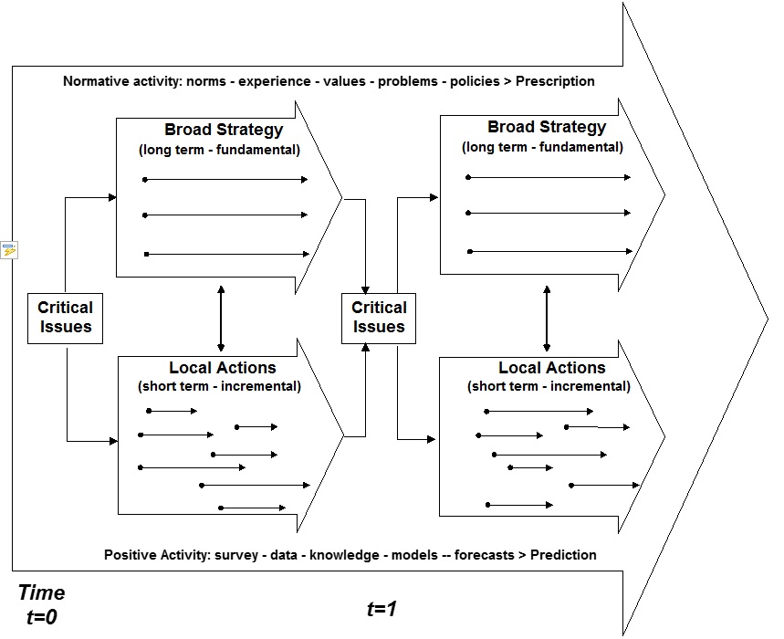
A generalized view of such a multi-level spatial planning system is known as the mixed scanning approach which was developed by Etzioni in 1967 (Parsons, 1995). It distinguishes between high-order social policy making processes that comprise normative activity that examine the values of society and set directions for change, and low-order processes that are more technical in nature and associated with the positivist (rational) activity in planning. The high-order activities are related to broad development strategy focused on a limited number of key concerns as represented by the 3 arrows (see Figure 7.1 ) and another that concerns numerous local actions or projects that have variable starting times, duration and focus, as represented by the multiple arrows in the Local Actions activity. This is in line with a view of spatial planning that is based upon a hierarchy of plans, e.g. a National Plan indicating the general structure of proposed development in relation to a general risk assessment and other development opportunities and constraints and a set of more detailed local development plans based upon more detailed, locality specific risk assessments and other local development issues. The two levels are closely related to one another and each level should be aligned to the plans at the other. These vertical interplays, shown as vertical arrows connecting the two planning levels in Figure 7.1, can be considered as mutual feedbacks between the two levels of spatial planning. Detailed local development plans typically provide a statutory basis for development control based on regulatory requirements for land use, density, plot sizes etc. and provide developers and land owners with a degree of certainty and clarity about their rights and obligations with respect to their land holdings. These plans should also include specific reference to disaster risk levels, which may be such that development is subject to risk reduction conditions or even perhaps prohibited.
Over time the planning process is repeated; planning law usually specifies a cycle of plan review. The process includes normative activities (related to societal values and political judgments) as well as positive activities (i.e. actions relate to data collection, analysis and modeling that are intended to increase objectivity), which planners and other societal actors are involved in. Public participation and collaborative planning are also often required by law.
Figure 1: The mixed scanning approach to planning (based on Bracken, 1981 and Parsons, 1995)
.
Given high levels of uncertainty about disaster risk and other development related issues some flexibility is required with the planning system. Flexibility is required to respond to changing economic conditions that may affect housing affordability for instance, but also to respond to changing risk in the aftermath of hazardous events that could significantly alter the risk levels of existing or proposed development areas. Here there is also a tension between those who advocate for lower planning and building standards for low-income groups, and those who advocate high standards in response to hazards. Such trade-offs should be confronted by a broad stakeholder platform as there are no straightforward solutions to these choices, which are inherently political. Many of the analysis methods available through the CHARIM website (e.g. Multi-Criteria Evaluation, Cost-Benefit Analysis, scenario analysis, etc. can be found in the Methodology book chapter 6) can be used to provide insight into such trade-offs and support the multi-stakeholder dialog and decision making process on such trade-offs. These tools may not solve the problems but they can at least increase the transparency of the trade-offs being made and help to build public support and commitment for spatial planning decisions.
Participatory planning systems
Specific characteristics of participatory spatial planning are the mutual linkages between action and knowledge and the emphasis on the experiences of planning practice as a source of knowledge. Collaborative spatial planning aims for high levels of participation as a starting point and it is very much concerned with the promotion of informed and committed citizens, autonomy, justice and equality but also recognizes that plan implementation is largely determined by engaged and committed citizens and private sector, as it is they who invest most in construction and development. Their investments should be coordinated and facilitate by public investments and actions such as infrastructure provision for example.
Moreover, in situations such as found in the small island states of the Caribbean, professional knowledge and resources are relatively scarce, making stakeholder engagement in DRR even more important. Partnerships between societal groups (e.g. Public Private Partnerships) are often encouraged as a means of increasing the power of non-state actors in determining development decisions and changing the role of the state from provider to facilitator of urban service provision and development.
The high ambitions of collaborative planning often prove hard to meet. All planning systems require some form of public participation but in practice it is likely that this will result in lower levels of participation[1] such as informing and consulting citizens being adopted rather than higher levels in which joint or even independent actions by citizens are supported.
Planned and unplanned spatial (urban) development and housing
Ideally, planned development is created through the formal planning process in which the demands of major actor groups (public organizations, development firms, individuals and households) for land and services should be known or estimated and are satisfied by the allocation of suitable land (i.e. low risk and spatially efficient and affordable) for various functions, such as housing. These lands should then be serviced and sold or allocated to the various activity agents who can then pursue their various development goals. This planned urban development processes is divided into 2 phases (see Figure 2), somewhat similar to those described by Etzioni above. The phases in the formal model of urban development are:
National Planning Phase: public authorities undertake broad zoning of land (spatial/land use planning) and provide trunk infrastructure; public and private developers consolidate land in preparation for actual site development. Activities are performed at a cycle of approximately 10 years and guide a series of annual site development cycles throughout the Local planning and Development Phase (Phase 2).
Local Development and Control Phase: detailed planning of subdivision layouts and land use allocation at plot level (P), provision of minor infrastructure to service individual plots (S), building of required structures (B) and occupation by the users (O). This is referred to as the PSBO model.
The PSBO model consists of a sequential series of processes that are designed for orderly land development. The various steps are dependent upon a set of planning norms and regulations that provide a basis for the preparation and implementation of plans at both levels. An important assumption here is that the norms and regulations are appropriate to the local context. They should not only be technically sound, including the provision of risk reduction measures, but they should also be grounded in the local culture, reflect the behavior and aspirations of the population and be affordable. The poor performance of plans is often associated with a disjuncture between planning and building standards and the local context, and lax enforcement.
The PSBO model is also based on other assumptions about the behavior of actors in urban development. In Table 1 some of these assumptions are listed in relation to the 3 basic actor groups suggested above, those that may be expected to be found in market economies. Fundamental pillars of such systems are the recognition of individual property rights in the ownership and use of land, relatively strong public authorities and well-developed and active development firms and finance organizations that attempt to extract profit from the construction of buildings, including housing, for sale or rental to individuals and households. In the CHARIM context, many of the above assumptions may not be satisfied.
Table 1: Assumptions related to the roles of different actor groups in planning processes
|
Public planning and utility agencies |
|---|
|
Demand for land and services are known or can be relatively easily established Resources required for service provision are available or can be recovered from users over time via user charges or taxes A form of serviced development can be provided to cater for all income groups Rural land owners will agree to sell land to developers or develop according to plan Accurate land tenure information is available Conflicting demands for land can be resolved to the satisfaction of all parties Detailed knowledge of hazard, vulnerability and risk levels are available |
|
Households |
|
Households can afford to buy or rent serviced buildings Households buy or rent and occupy serviced buildings created via the formal system Households have a regular source of income Households have access to affordable mortgage finance |
|
Development firms |
|
Public and private developers able to satisfy demand for shelter and other land uses Speculative land assembly will not take place in anticipation of zoning (planning) Land zoned for development will not be withheld for speculative purposes Developers have a good understanding of market (user) requirements |
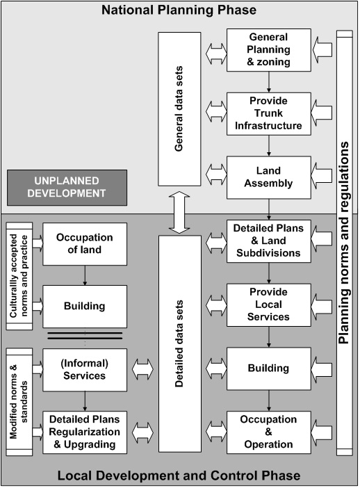
Unplanned urban development
Unplanned development may occur parallel to planned development, often as a result of the inadequacies of the formal planning systems at national and local levels to deal with low income housing. Unplanned development offers certain advantages to poor households (e.g. lower costs, lower standards, faster) but is not without shortcomings, not the least of which is the increased likelihood that sites that are exposed to significant hazards may be occupied. However, unplanned development enables low-income households to find affordable shelter and income generating opportunities in locations that would be otherwise impossible via planned development.
The unplanned development process differs from the planned PSBO model in several ways. First, the sequence of site development differs in that land occupation and building precede planning and servicing: following what Baross (1986) terms the OBSP process (Figure 3). Second, the OBSP process operates in parallel to the planned PSBO process and rather than being under formal design and control mechanisms, it is guided by informal institutions and practices that are grounded in the local culture and practices of informal land management. Third, the first stage of the OBSP process, land occupation, is often the result of informal land transactions that may take a variety of forms. Fourth, the OBSP process may be subject to temporal discontinuities: while occupation and building are processes that occur despite the intentions established in formal plans, the latter stages of servicing and planning effectively require at least the same amount, if not more, intervention and investment by the government as in the case of planned development and they are therefore subject to the similar capacity and resource problems that affect planned development processes. The servicing and planning stages will therefore only occur if and when the necessary resources are available for settlement upgrading to take place. Therefore in situations where there is a high proportion of unplanned development, it will be necessary to set priorities for interventions and to phase them over an extended period.
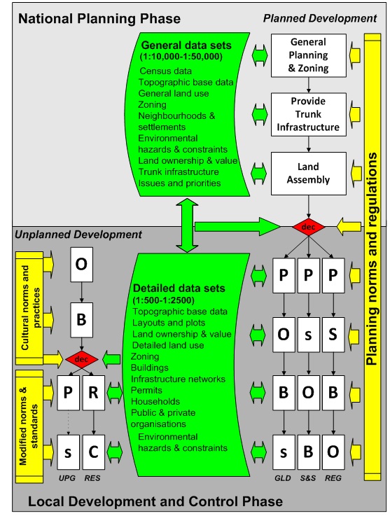
The OBSP process is related to unplanned settlement upgrading. Although some form of upgrading is now the most common response to unplanned development it is not the only retroactive intervention possible. Resettlement is another option for unplanned settlements (see Use Case Book 2.4) that involves the movement of residents to alternate, planned sites, such as a site and service scheme (S&S) or Guided Land Development (GLD) and the subsequent clearance of abandoned buildings. Resettlement is an instrument for those settlements on hazardous sites for which hazard mitigation options are not feasible. Extending Baross - model to include these types of interventions creates a process of Occupation, Building, Resettlement and Clearance (OBRC) as an additional form of intervention that is linked to one of the other forms of formal development such as PSOB or POBs (Figure 4).
Figure 2: The formal spatial planning development process (PSBO Model) (adapted from Baross 1986)
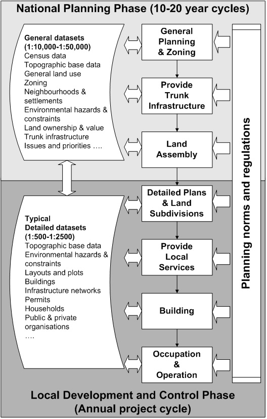
Figure 3: Models of planned and unplanned local development (adapted from Baross, 1986)
These retroactive interventions have a dual purpose. In the first instance they aim to provide a direct improvement of the living conditions in unplanned settlements by creating a more orderly spatial development and/or through the provision of services. They also have the effect of bringing the unplanned settlements either partially or fully into the realm of planned (formal) development. The extent to which a specific settlement is formalized will depend on the nature of the particular intervention.
As these examples show, the unplanned (informal) and planned (formal) systems for land and housing are linked whenever interventions are planned and implemented. However, if there is much unplanned developments and there is a lack of capacity in the public sector to formalize them, then it is advisable to concentrate first on the implementation of a measures to either mitigate hazards or relocate the settlements from very hazardous locations. Pragmatism is called for in developing programs related to unplanned settlements. It is important to utilize the capacity of the informal institutions and actors to deliver land, housing and services while at the same time enabling them to play a more substantial role in steering the individual private developments in such a way that disaster risk is reduced.
Figure 4: Options for responding to unplanned development (adapted from Baross, 1986 and Sliuzas, 2004)
Connecting spatial planning and risk management
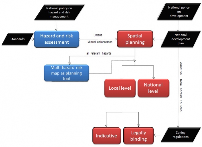
The integration of hazard and risk information into spatial planning is required at both national and local levels. This section explores in more detail some of the generic steps in spatial planning (i.e. the steps that may be undertaken to arrive at a National land use zoning plan or a detailed land use zoning plan as described above based upon the model of Baross).The integration of hazard and risk information into spatial planning requires many aspects. For example, policy, availability and access to required data, platform for sharing data, institutional mechanisms for mutual collaboration among partners, and importantly, awareness and technical know-how on what is needed (what critical information is required for a particular spatial development problem), how to generate such information and how to combine different sets of hazard and risk data and use them for making planning decisions as illustrated in the figure below.
Figure 5: Risk Management and Planning
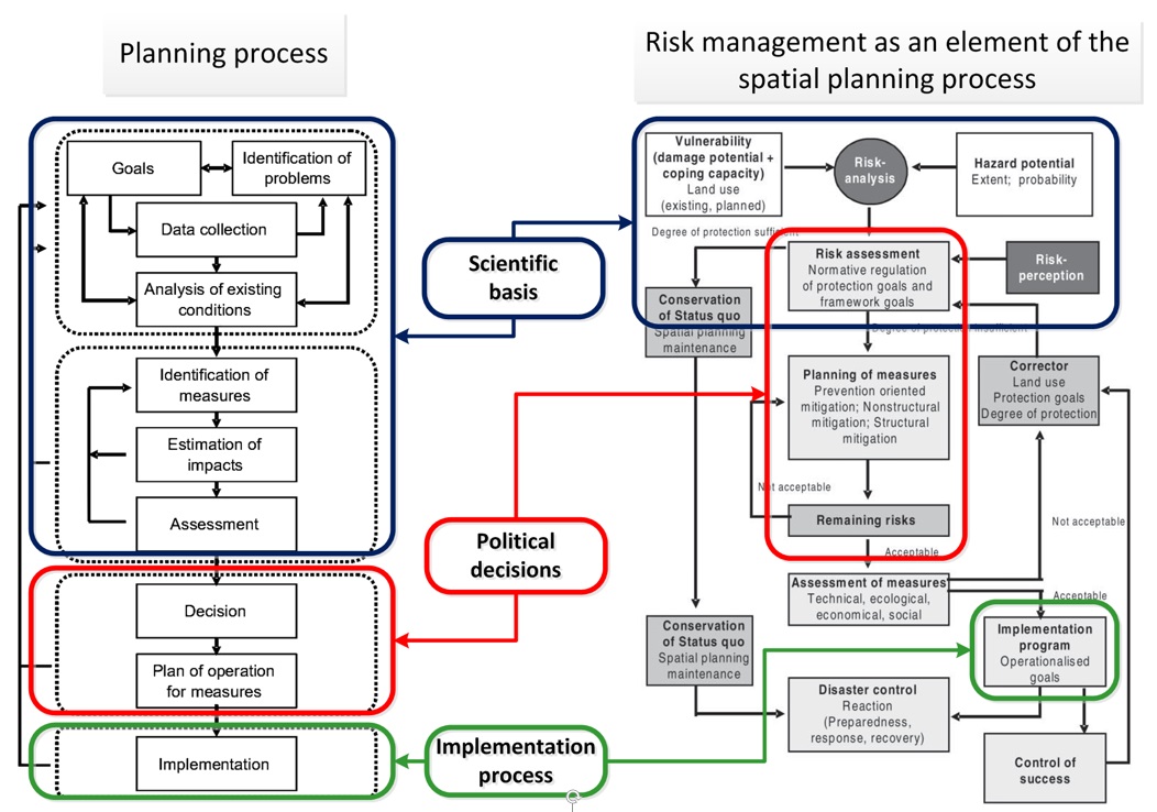
There are many different models of spatial planning but the work of Greiving and Fleischhauer (2006) is a useful reference point for this discussion as they have written specifically about the relationship between risk management in spatial planning (Figure 6). They have described a generic spatial planning process consisting of four main phases: Problem analysis, Assessment of alternatives, Decision and Implementation. The first two phases provide the scientific basis for political decision making and later implementation. Various planning tools and methods will be useful in the first two phases (e.g. tools for problem analysis and framing, techniques related to stakeholder participation and community engagement, as well as more technically sophisticated tools such as GIS analysis tools, and a myriad of methods that can be grouped under the heading of spatial planning support tools that might include multi-criteria assessment, environmental impact assessment, social impact assessment, etc. - examples of several of these methods are given for example in Methodology Chapter 6).
This framework clearly shows how risk management and spatial planning are interconnected. The risk management process includes scientific studies to which spatial planning databases might contribute especially in the realm of vulnerability analysis, political decision making processes related to risk in which the implications for spatial plans should also be considered and implementation processes in which compliance with spatial plan specifications should also be considered. Similarly, risk management process informs and contributes to the scientific analyses performed during plan making in which risk assessment data can be integrated with sectorial planning issues and problems related to housing, infrastructure, education, health, etc. in the analysis of existing development problems and the assessment of possible alternative futures that will be brought forward for decision making.
Spatial planning is considered to be an important part of integrated disaster risk management (FOSD, 2006). Its contribution in the long term disaster mitigation is quite evident. As disaster mitigation is aiming at minimizing damages to people and assets before a disaster strikes. The spatial planning measures are preferable and given higher priority over technical (structural) measures when it comes to long term mitigation and prevention of risks (FOSD, 2006). Spatial planning makes decisions on allocation and use of land for society; therefore, in a way it influences the vulnerability in cases of spatially relevant natural hazards (Greiving & Angignard, 2014). Fleischhauer et al. (2006) have identified four possible roles of spatial planning in risk management namely;
- Keeping areas free of future development that are; a) hazard pone, particularly with history of occurrence of disaster events, b) needed to lower the effects of hazardous event (e.g. flood retention basins), and c) needed to enhance effectiveness of disaster response (e.g. evacuation routes etc)
- Differentiated decisions on land use - allocating land for different uses based on hazard intensity, frequency or other hazard criteria. For instance flood prone areas may be used for agriculture purposes and may be forbidden for residential or siting of critical buildings, avoiding construction on steep slopes but encouraging forestation on those areas etc.
- Regulating land use by legally binding status - for instance regulating building density in earthquake prone areas, recommended roof types for buildings in the hurricane belt, or prohibition of basements in flood prone areas.
- Hazard modification - spatial planning can contribute in reduction of hazard potential of some of the natural hazards such as floods. This can be achieved by influencing intensity and frequency of a hazard.
Other important aspects of their approach are:
- The importance of both horizontal and vertical interplays between organizations operating under different mandates. These interplays are a result of the multiple actors, sectors and levels involved in both spatial planning and risk management and the lack of an overriding authority that can enforce harmonization between sectoral goals and plans.
- The position of spatial planning as an important end-user of risk assessment data.
- The need to ensure that the most up to date information is exchanged from one realm to the other so that the consequences of risk changes in the real-world are reflected in plans and planning decisions as soon as possible and that the implications of proposed planning decisions, which may have implications for future vulnerability levels, are assessed for their influence on risk.
Figure 6 Risk assessment and management as planning process (adapted from Grieving and Fleischhauer, 2006)
Spatial planning and hazard data requirements
Hazard and risk assessment information should be considered at both national and local levels of spatial planning. The scale and type of the hazard information should be appropriate for the specific level of planning (e.g. small scale, national hazard maps will not provide sufficient details to be used for detailed planning at the local level). Moreover, the available hazard information as well as the locations of vulnerable objects (elements at risk) should as much as possible reflect the current situation on the ground. Spatial planning should also be based on a specific return period of all relevant hazards (e.g. 50, 100 years floods). It is also important to consider for which land-use period (current situation and/or future scenario) risk should be assessed and evaluated. The information on future development scenarios should therefore be evaluated against future hazard scenarios in order to have insight into possible future risks.
Spatial planning requires reliable hazard related information. For instance hazard information is needed by planners to decide which areas should be prohibited for future development due to excessive risks or to allocate land for potential uses on the basis of hazard intensity or recurrence interval. Different types of hazard maps, risk assessment information and related guidelines serve vital sources to inform planning decisions (many examples of hazard and risks assessments are described in the CHARIM use case book). Table 2 provides an overview of hazard information that is considered to be relevant for spatial planning. This table was compiled under ARMONIA project (Fleischhauer et al., 2006). Since, in the CHARIM context, spatial planning usually takes place at national and local levels the required information has also been grouped under each planning level referring to relevant hazards.
It is evident from table 2 that various hazard datasets (both qualitative and quantitative) are required for each level of planning. For local level planning quantitative data (e.g. flood height, velocity, intensity, frequency etc.) is essential to make differentiated decisions on building construction, for instance, which construction type or occupancy type could be allowed or not allowed in a particular area subject to hazard potential. Since, spatial planning has to decide on spatial development options for all localities, all relevant hazards in each planning area should be considered to an appropriate level of detail. It is essentially the responsibility of the spatial planning authority to combine all relevant hazard information and make appropriate planning decisions for each planning area.
In some countries the national law obligates the local authorities to create hazards maps and use them in spatial planning. For instance, in Switzerland concerned public authorities are obliged to produce natural hazard maps and consider them in land use planning and other activities affecting space (FOSD, 2006). Therefore, Switzerland has spatial planning regulations based on specific hazard criteria. Multi-hazard risk maps must be considered when making plans and in deciding upon (re)development proposals. Such Multi-hazard risk maps general contain 3 zones (high risk - prohibited for construction; medium risk - construction subject to special conditions; low risk - construction permitted with no special restrictions). Such maps should be regularly updated to reflect changing hazard conditions but, Due to their relative simplicity, are extremely useful in decision making and in conveying risk related information to citizens and landowners with development aspirations.
Table 2 : Overview of requirements of spatial planning for hazard related information (adapted from Fleischhauer et al., 2006).
|
Issues |
National scale land use planning |
Local scale land use planning |
|---|---|---|
|
Planning aim |
|
|
|
Risk mitigation planning instruments |
|
|
|
Required river flood hazard information |
|
|
|
Required landslide hazard information |
|
|
|
Required coastal hazard information |
|
|
|
Required earthquake hazard information |
|
|
|
Required forest fire hazard information |
|
|
|
Required volcanic hazard information |
|
|
|
Required contents of hazard and risk maps |
|
|
In some countries the national law obligates the local authorities to create hazards maps and use them in the spatial planning. For instance, the Swiss law (rivers engineering and forestry law) makes special provision and obligates concerned authorities to produce natural hazards maps and consider them in land use planning and other activities affecting space (FOSD, 2006). Therefore, countries like Switzerland have spatial planning regulations based on specific hazard criteria. The Swiss risk concept from PLANAT (National Platform Naturgefahren) defines three intensity classes; based on flood depth and velocity (table 2.2) for flood vulnerability analysis and these are being used as basis for spatial planning regulations (Papathoma-Kohle, Kappes, Keiler, & Glade, 2010)
|
Intensity class |
Criteria |
Description |
|---|---|---|
|
High |
h > 2 m or v x h > 2 m2/s |
Persons inside and outside of buildings are at risk and the destruction of buildings is possible or events with lower intensity occur but with higher frequency and persons outside of buildings are at risk |
|
Moderate |
2 m > h > 0.5 m or 2 m2/s > v x h > 0.5 m2/s |
Persons outside of buildings are at risk and damage to buildings can occur while persons in buildings are quite safe and sudden destruction of buildings is improbable |
|
Low |
h < 0.5 m or v x h < 0.5 m2/s |
Persons are barely at risk and only low damages at buildings or disruption have to be expected |
Conclusion
It is evident from the above table that various hazard datasets are required for each level of planning. Also, the question of type of data i.e. qualitative or quantitative is also important aspect to take into account when deciding on data. Mainly, for local level planning quantitative data, e.g. flood height, velocity, intensity, frequency etc is essential to make differentiated decisions on building construction, for instance, which construction type or occupancy type could be allowed or not allowed in a particular area subject to hazard potential. Since, spatial planning has to decide on space, therefore, essentially all relevant hazards in that particular area to be considered. It is essentially the responsibility of spatial planning to combine all relevant hazards related information and make appropriate planning decision for that particular area.
Spatial planning can play a significant role in integrated disaster risk management (FOSD, 2006), particularly through its potential contribution to long term disaster mitigation. Effective risk-based planning aims to minimize damages to people and assets before a disaster strikes, but its performance in disaster mitigation requires a high level of technical and political cooperation and coordination, and equally a commitment from other societal stakeholders as partners in sustainable development.
References:
Alam, M. 2015. Application of national census data for vulnerability assessment and spatial planning in Grenada. Unpublished MSc thesis University of Twente, Faculty ITC.
http://www.itc.nl/library/papers_2015/msc/aes/alam.pdf.
Baross, P. (1986). Land supply for low income housing: issues and approaches. UNCRD: Urban Shelter and Services for the Poor.
Burby, R. J., Deyle, R. E., Godschalk, D. R., & Olshansky, R. B. (2000). Creating hazard resilient communities through land-use planning. Natural Hazards Review, 1(2 (May)), 99–106.
Fleischhauer, M. (2008). The role of spatial planning in strengthening urban resilience. In P. H.J & K. I.A (Eds.), Resillience of Cities to Terrorist and other Threats (pp. 273–298). Springer Science + Business Media. doi:10.1007/978-1-4020-8489-8_14
Fleischhauer, M., Greiving, S., & Wanczura, S. (Eds.). (2006). Natural hazards and spatial planning in Europe. Natural Hazards and Spatial planning in Europe (p. 204). Dortmund.
FOSD, Swiss Federal Office for Spatial Development, (2006). Recommendation: Spatial planning and natural hazards (p. 36). Bern: Federal Office for Spatial Development (FOSD), Federal office for Water and Geology, Swiss Agency for the Environmnet, Forests, and Landscape. Retrieved from www.are.ch
Greiving, S., & Angignard, M. (2014). Disaster mitigation by spatial planning. In T. Van Asch, J. Corominas, S. Greiving, J.-P. Malet, & S. Sterlacchini (Eds.), Mountain Risks: From Prediction to Management and Governance, Advancesin Natural and Technological Hazards Research 34 (Vol. 34, pp. 287–302). Dordrecht: Springer Science + Business Media Netherlands. doi:10.1007/978-94-007-6769-0_10
Greiving, S., & Fleischhauer, M. (2006). Spatial planning response towards natural and technological hazards. In P. Schmidt-Thomé (Ed.), Natural and Technological Hazards and Risks Affecting the Spatial Development of European Regions (Special Pa, pp. 109–123). Geological Survey of Finland.
Nadin, V., Hawkes, P., Cooper, S., Shaw, D., & Westlake, T. (1997). Regional devlopment studies: The EU compendium of spatial planning systems and policies (p. 176). Luxembourg: European Comission
Papathoma-Köhle, M., Kappes, M., Keiler, M., & Glade, T. (2010). Physical vulnerability assessment for alpine hazards: state of the art and future needs. Natural Hazards (Vol. 58, pp. 645–680). doi:10.1007/s11069-010-9632-4
Parsons, W. (1995). Public policy: an introduction to the theory and practice of policy annalysis. Cheltenham, UK & Northampton, MA, USA: Edward Elgar.
Sliuzas, R. V. (2004). Managing informal settlements: a study using geoinformation in Dar es Salaam, Tanzania. PhD Thesis University Utrecht, http://www.itc.nl/library/Papers_2004/phd/sliuzas.pdf
United Nations Economic Comission for Europe (UNECE). (2008). Spatial planning: Key instrument for development and effective governance with special reference to countries in transition (p. 46). Geneva.
Some other sources for information on spatial planning and/or DRR
Botero Fernandez, V. (2009). Geo - information for measuring vulnerability to earthquakes : a fitness for use approach. ITC Dissertation;158. http://www.itc.nl/library/papers_2009/phd/botero.pdf
Montoya, L. 2002 Urban disaster management: a case study of earthquake risk assessment in Cartago, Costa Rica. PhD Thesis Utrecht University. http://www.itc.nl/library/Papers/MONTOYA.pdf
Sengupta, A., Bandyopadhyay, D., van Westen, C.J., Van der Veen, A.. 2011. Adapting a quantitative risk assessment based method to guide land use planning decisions in India. ITC Working papers series; 8 http://www.itc.nl/library/papers_2011/scie/sengupta_ada.pdf
UNISDR Prevention Web http://www.preventionweb.net/english/
[1] Sherry Arnstein’s seminal paper A Ladder of Citizen Participation, Journal of the American Institute of Planners, 1967. 35:4, 216-224) refers to 8 levels of participation from low to high: Manipulation, Therapy, Informing, Consultation, Placation, Partnership, Delegated Power and Citizen Control.