

This use case is developed to demonstrate the procedure that can be followed to develop guidelines for the planning and design of buildings subjected to landslide, flood or both hazards. These guidelines can be either enforced independently or as part of the general building codes or as the structural design codes. Examples of buildings the guidelines can be applied to include:
Bexon Primary School, Cannaries Primary School and Roseau in St. Lucia
Milton Cato Memorial Hospital, Kingstown, St. Vincent and the Grenadines
Keywords:
Flood mitigation, elevation, flood proofing
| Before you start: | Use case Location: | Uses GIS data: | Authors: |
|---|---|---|---|
|
Section 3.1.3 Critical Infrastructure can be read before this use case and can also relate to Chapter 8 Critical Infrastructure section 8.1 Introduction in methodology handbook. |
Bexon, Cannaries, Roseau in St. Lucia Milton Cato Memorial Hospital, Kingstown, St. Vincent and the Grenadines |
No | Naveed Anwar |
Introduction:
Due to the topography and location of the countries in the OECS, the risk of landslide and flood hazards is fairly high.
The current draft of the building codes and the building design procedures do not explicitly consider the flood and landslide hazards and there does not seem to be any specific guidelines that are being followed. While these hazards should be considered in the land use planning, location and design of all buildings, it is important that the buildings used as essential facilities such as fire stations, hospitals, schools and or used as shelters, be specially designed to have a higher resilience to these disasters.
Objectives:
The purpose of this use case is to indicate the analysis process required to determine overall hazard and vulnerability due to the building characteristics that effect the resistance to floods and landslide, including an analysis of different options for strengthening buildings with consideration to retrofitting and other available measures. It can be referred to Use case 3.3.1 and 3.3.2 as well. It also provides classification of critical infrastructure buildings for different sectors and differentiate these buildings based on the design parameters as well as provide considerations for the multiple usage of buildings in the case of shelters for schools and churches.
Flowchart:
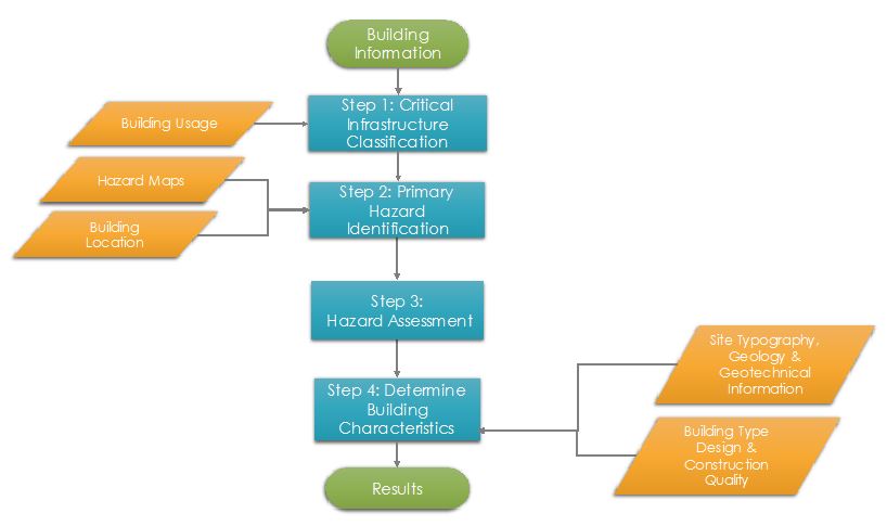
Figure 1: Overall process to indicating the steps to determine the building characteristics for critical buildings.
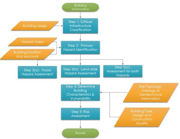
Figure 2: Detailed Overall process indicating the steps to determine the risk for critical buildings
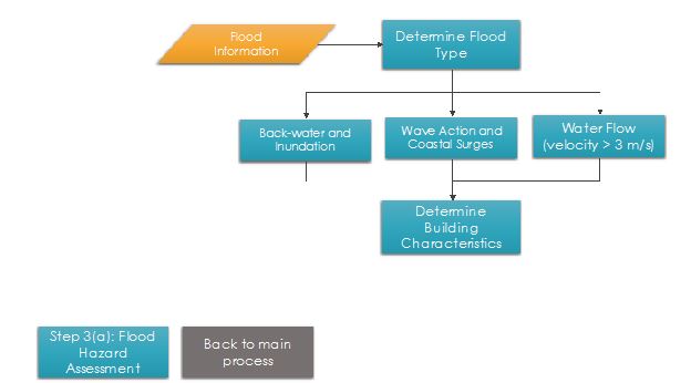
Figure 3: Detailed Step 3(a): Flood Hazard Assessment
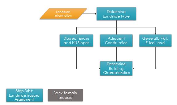
Figure 4: Detailed Step 3(b): Landslide Hazard Assessment
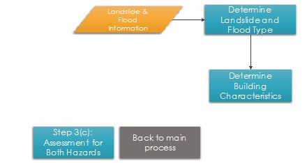
Figure 5: Detailed Step 3(c): Assessment for both hazards
Problems definition and specifications:
Buildings for critical infrastructures require special attention during the planning and construction phase as these buildings often serve as housing facilities and cater to large groups of people and are often utilized in a post disaster situation, providing the necessary shelter and support. Due to the importance of these building, the following considerations need to be addressed:
- Classification of buildings as critical and essential in various sectors
- Determining the hazards that they are exposed to due to their location
- Guidelines for identifying the building characteristics that are relevant and should be considered
- Examples of some of the buildings where such hazards are significant and may not have been considered
Data requirements:
In order to determine the building characteristics that are needed to address the risk of a building to flood and landslide hazards, the following data might be required:
- Building usage and classification
- Building location and land use maps
- Hazard maps
- Site topography, geology and geotechnical information
- Building type, design and construction quality
Analysis steps:
General Application
Step 1: Classification of Critical Infrastructure
To develop guidelines and special provisions for disaster resilience of buildings that are part of the critical infrastructure, the first step is to define and categorize them for this purpose and integrate this classification with existing categories in the building codes.
The occupancy classification in the draft building codes of OECS are primarily based on the usage in-terms of the number of persons and storage of hazardous materials. They are not classified in terms of critical, important or essential functions they perform or the activities they house, as shown in the Table 1.
|
GROUPS |
CHARACTERISTICS |
|---|---|
|
Group A - Public Buildings |
Buildings in which 50 or more persons regularly congregate. |
|
Group B - Institutional Buildings |
Buildings in which inmates liberties are restricted. |
|
Group C - Commercial and Industrial Buildings |
Buildings used for manufacture, assembly, servicing, repair and factory operations where no hazardous processes or materials are involved. |
|
Group D - Office, Administrative and Retail Service Buildings |
Buildings used for business or professional transactions or the display or sale of materials or finished products. |
|
Group E - Residential Buildings |
Buildings in which sleeping accommodation is a necessity. |
|
Group F - Hazardous Occupancy Buildings |
Buildings or parts of buildings for the storage or handling or use or processing of any of the hazardous materials or for the housing or carrying out of any of the hazardous processes. |
Table 1: Sample grouping of buildings and specific characteristics - St. Lucia building code
The International Building Code (IBC), and ASCE 7-10 use a Risk Category approach for classifying the buildings for the purpose of structural design. These risk categories are based on the "consequence" of the failure or damage of buildings in case of a disaster. These codes, then specify an "Impotence Factor" to increase the hazard level for buildings in higher risk categories, hence indirectly incorporating higher disaster resilience. IBC also has an "Essential" category of buildings that need to be operational during and after a hazard event or disaster and these are placed in the highest risk category. These considerations are summarized in Table 2.
|
OCCUPATION CATEGORY |
NATURE OF OCCUPANCY |
SEISMIC IMPORTANCE FACTOR |
|---|---|---|
|
I |
Buildings and structures that represent a low hazard to human life in the event of failure |
1.0 |
|
II |
Buildings and other structures except those listed in Occupancy Categories I, III and IV |
1.0 |
|
III |
Buildings and other structures that represent a substantial hazard to human life in the event of failure. |
1.25 |
|
IV |
Buildings and other structures designated as essential. |
1.5 |
Table 2: Risk category of buildings and other structures (Source: IBC 2012 and ASCE 7-10)
The categorization and concepts of IBC/ASCE and the draft OECS codes can be used to as a rational for defining critical infrastructure. It may be a building/structure or facility that is essential for providing continuity of basic services and relief during the disaster or after it. Based on this definition, the following types of buildings and structure may be classified as essential or critical and are specifically evaluated using the process outlined in this use case.
|
Sector |
Building / Facility |
|---|---|
|
Health and emergency services |
|
|
Education Sector |
|
|
Service Infrastructure |
|
|
Hazard facilities and protective infrastructure |
|
Table 3: Proposed categorization of buildings in various sectors as Essential/Critical
Step 2: Primary Hazard Identification
Based on the hazards map analysis and building location, primary hazard should be identified that can affect the critical infrastructure and further information should be collected related to hazards.
While the best way to mitigate land slide and flood hazards is to consider these hazards during the planning and location phase and avoid areas where such hazards exists. However, the existing critical infrastructure might be located in a hazard prone area.
Step 3: Hazard Assessment
The overall hazards of the buildings can be determined by referencing the available hazard maps, both for landslides and floods. Depending on the scale and types of the maps, additional information about the specific hazard subtype and intensity may need to be determined for the building location. GIS based information such as location, topography, elevation, surrounding, structures and features are essential for this step.
Step 3a: Flood Hazard Assessment
Flood assessment should be carried out by determining the potential flood type which can be further based on three main characteristics, Water Flow, Wave Action and Coastal Surges, a Back-water and inundation. (Please refer to MB section 8.4 and 8.5 for Flood types and details). The flood hazard type will affect the risk assessment for the corresponding building characteristics and vulnerabilities.
Step 3b: Landslide Hazard Assessment
Landslide Hazard assessment should be carried out by determining the potential landslide type which can be further based on three main landslide types: Sloped Terrain and Hill Slopes, Flat and Filled Land, and Adjacent Construction.
Step 3c: Hazard Assessment for both (flood and Landslide)
The combined hazard, both due to flood and landslide should be evaluated and the possible effect of one or the other should be considered such as the flooding leading to landslide and landslide leading to inundation.
Step 4: Determining Building Characteristics
The risk buildings face due to land slide and floods a combination of the overall hazards posed by the location, as well as vulnerability of the specific site characteristics as well as the vulnerability of the specific site characteristics and vulnerability of the building structure c characteristics. Certain types of building structures are more vulnerable than others. A basic building characteristic can help to determine the overall vulnerability and can serve as the initial step, before the determination of detailed characteristics, as shown in the table for OCES building types.
|
Building Structure Category |
Vulnerability for Floods |
Vulnerability for Land slides |
|---|---|---|
|
Reinforced concrete frame, with masonry infill walls and concrete roof |
|
Low to medium and will depend on foundation type and landslide hazard type |
|
Timber frame with wooden walls and metal sheet or wood tile roofing |
|
|
|
Unreinforced stone or brick masonry with metal sheet roofing |
|
|
|
Steel frame structures with high weight partitions and metal steel roofing |
|
|
The vulnerability of the building not only depends on the characteristics of the building but the specific vulnerability of the site itself such as the type of soil, the presence of adjacent vulnerable buildings, the local topography, presence of water ways, and nearby vulnerable buildings that may increase the hazard level and may add to vulnerability of the building. These factors should also be considered in the analysis as far as its practical.
Building Characteristics to be considered for Flood Resistance
For water flow where velocity is greater than 3 m/s, the presence of the following characteristics will reduce the vulnerability depending on the water depth.
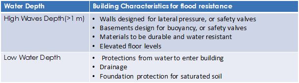
Table 4: Building Characteristics to consider for resistance of water flow
For wave action and coastal surges, the following building characteristics can be used for increasing resistance and reduce vulnerability:
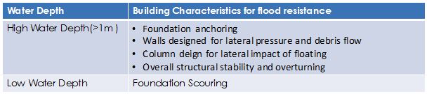
Table 5: Building Characteristics to consider for resistance from wave actions and coastal surges
For back-water and inundation, following are the building characteristics for increasing resistance and lower vulnerability:
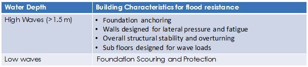
Table 6: Building Characteristics to consider for resistance from back-water and inundation
Building Characteristics to be considered for landslide resistance
For Sloped Terrain and Hill Slopes, building characteristics that effect the resistance according to different types of landslides is provided in Table 7.
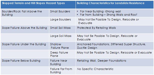
Table 7: For resistance towards slopped terrain and hill slopes landslide
The building characteristics that effect the resistance to land slide in flat and filled land:
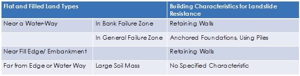
Table 8: For resistance towards flat and filled landslide
For excavation sides will be protected by sheet piling, bracing and by installing monitoring system for movement.
Other mitigation considerations to reduce risk
While the best way to mitigate land slide and flood hazards is to consider these during the initial planning and location phase by avoiding hazardous areas. For floods, it is also important to design the floor levels to be above the flood inundation levels. However, if the buildings have already been constructed and such hazards were not considered previously than the following options may be considered for improving the resilience.
a) Floods
- For low flood levels, provide raised barriers to prevent water from entering the lower floors and basements
- For higher flood levels, allow the lower levels and basements to be flooded to avoid high pressure on walls
- Use basements and lower floors for non-sleeping, non-essential purposes, avoid storing valuables, or ability to move to higher levels if flood warning is issued
- If possible, add additional floor in the building, if the highest floor is below the expected flood level.
- Creating an attic in sloped roofs may also be considered for temporary safe space, and a hatch for access to the roof for rescue
b) Land Slide
- It is generally not practical to mitigate land slide hazards to carry out retrofitting in buildings once they have been constructed. Most of the measures are to protect the buildings from landslide, which may include the construction of retaining walls, sheet piles, soil stabilization
- Sometimes it is beneficial to install monitoring systems and tell-tales to detect any movements and to either prepare for evacuation, bracing or underpinning of the buildings.
- Improving the draining around and under the buildings can also help to reduce the landslide hazard
- Constructing debris, mudslide and boulder retention walls or guards also helps to reduce damage due to landslides
Critical Infrastructures as Multipurpose Buildings
Many of the buildings identified as part of the critical infrastructure can be either designed or designated for multiple use to enhance their usability, which makes up for the additional investment that may be needed to make them disaster resilient at a higher standard and improve their performance.
For example, the schools which are critical for the safety of the children during a hazard and essential for the continuation of the education after a disaster may also be used as temporary emergency shelters for an expected hazard event, such as hurricane flood, or fire. However, care should be taken not to convert schools into long-term post-disaster shelters, which may affect the continuation of education. It may be more appropriate to use other community buildings, such as churches and community centers during emergency as well as possible post-disaster shelters. Designation of churches and other community buildings, may be more appropriate as shelters, as community members in the area will be familiar with their location, building layout, and facilities.
When considering multiple use of buildings, the essential services and resources needed during emergency and immediately in post disaster may be allocated a primary, as well as a secondary location. Some buildings designed for a higher performance criteria are generally well located to prevent damage during hazards, may be designated for multiple secondary use. For example, a well deigned public or office building for a particular department or ministry in normal usage, may be designated as secondary facility for other ministries or departments that may be located in vulnerable buildings. This is especially relevant to the OECS and smaller countries, where, many departments are employing relatively fewer staff. For more details, please refer to Use Case 3.3.5 and section 8.4 in Methodology Book.
Step 5: Risk Assessment
The overall risk assessment of buildings and critical infrastructure should be evaluated based on the categorization, the overall hazard levels, the site specific hazards, as well as vulnerability of the buildings with specific vulnerability of the sites.
A formal risk assessment for important and critical buildings should be ----- to the specialist in this -------.
Example Application: Case studies
Two buildings are examined to highlight the importance of considerations for flood and landslide hazards in determining the location and design of buildings that are part of critical and essential infrastructure.
1. Bexon Primary School, St. Lucia
The Bexon Primary School has been effected by floods several times. A visit to site and observations made from GIS maps indicates that the location of the school is prone to flooding and that appropriate mitigation measures can be taken based on the information and process defined in this use case.
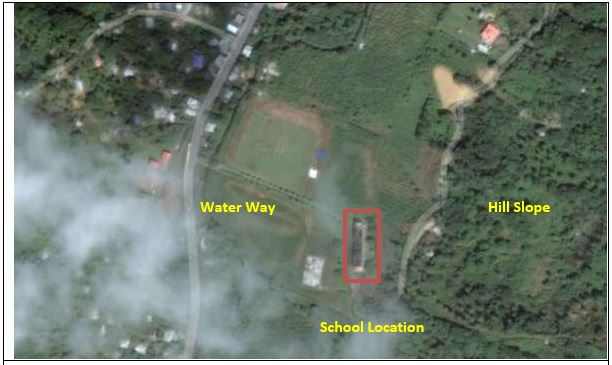
Figure 6: Google Earth image of the location of Bexon Primary School, St. Lucia.
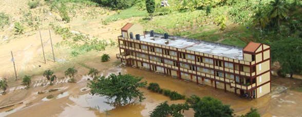
Figure 7: Bexon Primary School post Hurricane Tomas in 2010.
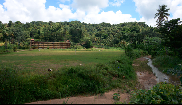
Figure 8: The school is located near to the hills and on the flood path and hence susceptible to floods and landslides.
|
Key Considerations |
Observations |
|
|---|---|---|
|
Academically High Standard |
|
|
|
Vulnerability |
Floods |
|
|
|
Seismic Activity |
|
|
Function as a shelter |
|
|
|
Apparent Risks |
|
|
|
Current Requirement |
|
|
|
Building Strengthening Options |
|
|
Table 4: Observations during visit to Bexon Primary School, St. Lucia
2. Milton Cato Memorial Hospital, Kingstown in St. Vincent and the Grenadines
The hospital has been effected by floods in more than one incidence in past few years, resulting in both economic losses and disruption of services.This hospital is a part of the critical infrastructure and a application of the process and guidelines presented in this use case can reduce such effects on similar buildings.
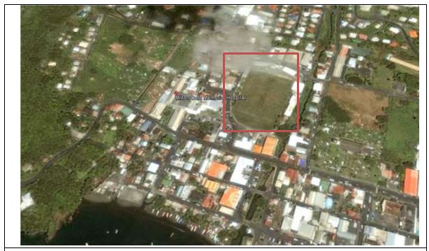
Figure 9: Google Earth image of Milton Cato Memorial Hospital, Kingstown, St. Vincent and the Grenadines.
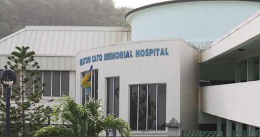
Figure 10: Milton Cato Memorial Hospital, Kingstown, St. Vincent and the Grenadines.
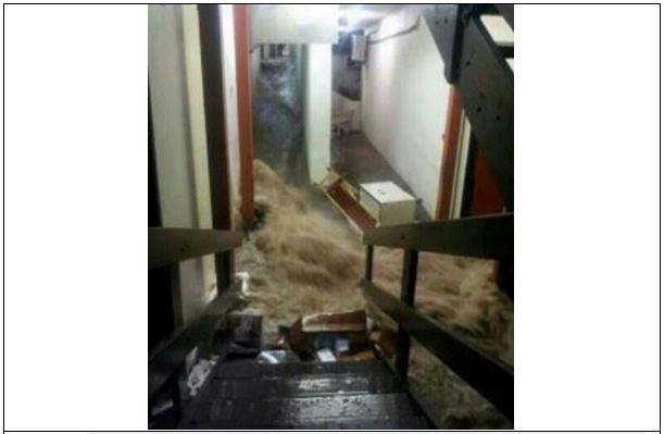
Figure 11: Water rushes through the children's ward at the Milton Cato Memorial Hospital (Photo: Jerry George in St Vincent) http://www.barbadostoday.bb/2013/12/25/severe-flooding-people-missing-in-st-vincent/
Results:
The expected result and outcome of this use case is to be able to develop guidelines that will help in proper identification, designation and location as well as the design of the buildings that are part of critical infrastructure in the OCES, for the flood and land slide hazards. For existing buildings, it will be possible to consider relocation or mitigation measures.
The use case will also help to identify vulnerable building types and characteristics that can help to increase resistance.
Conclusions:
Use of proper guidelines and building codes to identify and designate the buildings as part of critical infrastructure and to explicitly evaluate and mitigate the risk of floods and land slide can greatly enhance the safety and resistance of the buildings themselves and can also reduce the consequences of the disasters on communities and municipalities.
The examples above demonstrate that proper guidelines and considerations will be helpful to reduce the risk to critical and important buildings from flood and landslides.
Last update: 15-07-2016