

Belize
The CHARIM project has generated a number of thematic maps for Belize. On this page you can download the high-resolution PDF version of the maps, with complete cartographic representation. The digital maps can be consulted on the CHARIM Geonode.
Detailed topographic map
|
|
 |
Summary of the procedure to make the map:
This map was generated using a hillshading map generated from the Digital Elevation Model, which was made from an SRTM DEM. Elevation was also represented in colour, so that the combination of hillshading and elevation gives the best indication of the topography of the country. The generation of the individual thematic layers was carried out using the ILWIS software. Final map production was carried out using ArcGIS.
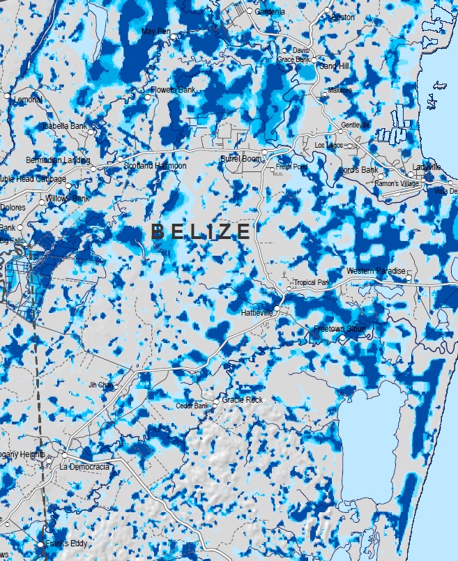
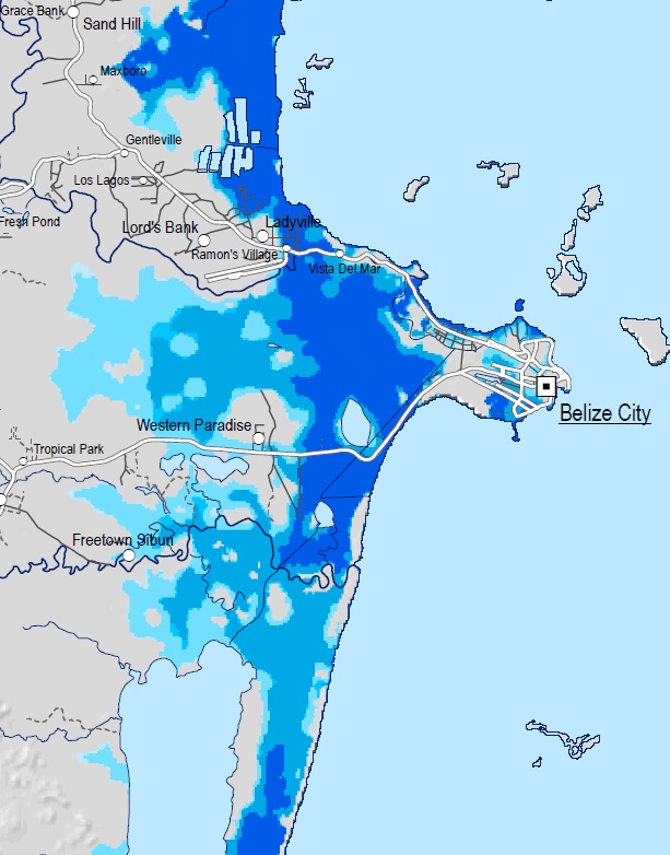
Flood Hazard Map
|
|
 |
Summary of the procedure to make the map:
The National Flood Hazard Layer has been generated using a state of the art Global Flood Hazard framework, improved with local data where such data is available. The framework contains a number of modules and sub-modules, and the structure is shown graphically in the flowchart. An explanation of the key modules is provided below:
(1a) Terrain Pre-Processor
The National Flood Hazard Assessment has been undertaken using a state-of-the-art Global Flood Hazard Framework developed by SSBN Ltd. It builds on 15 years of published research developed at the University of Bristol in the UK into fast, detailed hydrodynamic modelling of large scale flood hazard using global datasets to supplement local data where it is scarce. Below is a brief description of the framework of its application to Belize, linked to the flow chart by section number.
(1a) Terrain Pre-Processor
The relevant 3 arc second (~90 m) SRTM terrain tiles are extracted and joined to create a continuous DEM of the entire country. Urban areas are identified using satellite night time luminosity data and depending on the degree of urbanisation, a filter of varying strength is applied to the SRTM data to remove local high points (which represent building roofs) and reconstruct the surface by interpolating between the remaining lower points. Unwanted vegetation elevations are removed using an algorithm based on a global satellite based vegetation height dataset and canopy density dataset. A feature preserving smoothing algorithm is applied to the entire DEM to reduce the data noise error inherent to SRTM data. This results in a continuous, robust “bare-earth” digital elevation model of the whole country suitable for hydrodynamic modelling of river floodplains and coastal regions.
(1b) Channel Pre-Processor
It is critical to explicitly model river channels within flood models, as most water is conveyed across the land surface within them and their omission leads to severe over estimation of flood hazard. The channel network is generated using GIS-based hydrological analysis tools; the basic network used here was created as part of the HydroSHEDS project. The HydroSHEDS network for Belize was validated against the national river layer provided by the Government, with corrections made where necessary to ensure the data represented the national rivers correctly. Belize specific relationships of river width to upstream catchment area can be built by using aerial and satellite photography that relate measured river width to upstream accumulating area derived from the DEM. This relationship can then be used to estimate an appropriate width for all river channel cells within the model. River depth can be estimated using the Manning’s equation which relates flow to the channel capacity. To apply Manning’s equation we assume a bankfull discharge from the RFFA (see 2a), river width from the relationship described above, slope from the DEM, and typical channel roughness.
(2a) Regional Flood Frequency Analysis (RFFA)
The RFFA has been developed to enable return period discharges to be estimated anywhere on Earth based only on climate classification, upstream area and upstream annual rainfall. It uses a database of river discharge measured for many decades at 945 river gauging stations all over the globe, representing 70,353 station years of data. This method is used to generate robust flood flow estimates at any point along the river network in Belize. By making an assumption of bankfull return period (typically ~ 1 in 2 years) it is also possible to estimate bankfull discharge using the RFFA, used in step 1b to estimate channel depth. Local gauging station data is quality assessed and used to validate RFFA flows where available.
Note that the RFFA method operates for channels with an upstream area of greater than 40 km2. For channels below this size, intense rainfall is simulated within the hydraulic model as rainfall directly on the DEM terrain. The rainfall intensity for an event of given duration and return period is estimated using Intensity Duration Frequency (IDF) curves generated from local rainfall data if available, otherwise by using regional IDF curves.
(2b) Boundary Condition Pre-Processor
Hydrographs representing the change in flood flow over time are required to model the flood dynamically over time, allowing the model to account for water stored on the floodplain. These hydrographs are generated using the assumption of a triangular hydrograph, with the peak flow represented by the flow derived in 2a and the time-to-peak estimated by using Manning’s equation to calculate mean velocities along the length of the river network to the furthest point.
(3a) Hydrodynamic Model Build
The river network is decomposed (divided) into reaches, with each reach simulating its own flood hydrograph. Reaches are divided where the bankfull discharge changes by more than 5%, typically this is at river confluences and change points along the river network. Downstream boundary conditions are set to sea level if terminating in the ocean, or at DEM elevation if terminating inland.
(3b) Hydrodynamic Model Run
The models are executed (run) using a full 2D hydrodynamic model based on a simplified (for speed) momentum-preserving variant of the shallow water equations. The hydrodynamic model explicitly models channels using a sub-grid method that means the channel geometry is independent from the model grid resolution (DEM), allowing channels of all sizes to be represented even when modelling with coarser DEMs like SRTM.
A surface water routing scheme is incorporated into the model to handle situations where the assumptions underlying the shallow water equations are violated. This usually applies to areas of very steep or discontinuous terrain. The routing scheme moves water downslope at a velocity that is dependent on slope gradient; the velocity-gradient relationships were developed from empirical studies of surface water flow velocities.
Large rivers are modelled at 30 arc second resolution (~1 km), as a coarser grid produces a more stable simulation of water surface elevation on large flood plains. This is because coarsening the DEM reduces the noise present in SRTM terrain data. Small rivers and pluvial simulations are simulated at 3 arc second (~90 m) resolution, as the higher resolution is necessary to resolve the small scale topographical features that constrain the flow of smaller channels.
(4a) Post Processor
The 30 arc second (~1 km) simulations of large rivers are reprojected onto the 3 arc second (~90 m) DEM by interpolating between water elevations at the centre of each 30 arc second cell to create a smooth 2D surface of water elevations at 3 arc second resolution. Simulations of individual reaches are combined to create a continuous flood hazard map.
(4b) Validation
Validation of both input data and output results was carried out wherever existing local data was available and appropriate for the purpose. Validation of the river network against national network data showed model network errors located along Monkey River and were corrected to correspond with national network data and satellite imagery. Validation of flows and rainfall values from regional data were tested against quality assessed local data. In addition, the regionalised IDF curves used in Belize were compared to IDF relationships that have been derived in other, similar regions (e.g. Miami, Florida). Some localised LIDAR topography was used to assess the success of vegetation correction of the SRTM DEM. Flood hazard maps were also compared to previous flood related studies (Meerman, October 2008 Landsat flood extent; King et al., 1992 – geomorphological assessment) and compared with Ministry of Works and Transport (MOWT) records of flood locations and National Emergency Management Organisation (NEMO) photographs and reports of hurricane flood damages.
Coastal flood hazard map
|
|
 |