

This section of the methodology book explains the importance of collecting historical information on hazardous events. It explains the procedure of collecting historical information on flood and landslide events, and links to the results for the countries of Belize, Dominica, Saint Lucia, Saint vincent and the Grenadines, and Grenada.
Keywords: Historic, information, floods, landslides, triggering events
Author: Cees van Westen
Links:
- Use case on collecting historical hazard information
- Rainfall frequency analysis
- Use case hazard & loss databases
- Data management Book: HydroMet data
- Data management book: Disaster databases
- Data Management book: Landslide inventories
Introduction
Hazard inventories contain information on the date, location, type, damage and other characteristics of hazardous events, such as floods and landslides that have occurred in a particular area. There are several reasons why it is very important to compile information of past hazard events, which can be summarized in the statement: "We have to learn from negative experiences in the past in order to prevent them from happening in future, or at least reduce their impact"
- Where? This type of historical data forms the basis for assessing flood and landslide susceptibility. Past landslide inventories, for example are essential for susceptibility models that predict the area where landslides are more likely to occur in future by evaluating the topographic, geological, land use and other characteristics of past landslide events, and assuming that these combinations of factors might also be more landslide prone in future.
- When? We also need to know when past events have happened, as we want to correlate the hazard events with triggering events. When we know when floods and landslides have occurred in the past, we can analyse the specific rainfall patterns that lead to their occurrence. We can then apply magnitude-frequency analysis to find out the frequency of occurrence of past events which we use to estimate the probability of future events. For instance for landslide hazard assessment it is important if data from different triggering events are available, because then it is possible to characterize the susceptibility classes with the expected landslide densities that could occur with triggering events with different return periods. Ideally we would like to have a worst case scenario for each of the islands: what would happen in terms of landslide density if the island would be hit by a major hurricane or tropical storm. The availability of historical events is also important for flood hazard assessment, in order to determine which rainfall events have caused flooding, and if possible also where and how much.
- What? The information on the damage caused by past events is important to analyse the vulnerability and risk for future events. Historical damage information is important to generate local vulnerability curves, by combining hazard intensity with damage data (See Use Case 7.2 on generating physical vulnerability curves).
Historical information on past hazardous events is always incomplete. Like it is in many other aspects of life, we prefer to forget the bad things that happened as soon as possible, and get on with our lives. Even though the National Emergency Management Organization has the mandate to develop and maintain a database on past hazardous events, this is often not implemented adequately, and only the largest events are recorded. Public Works Departments generally also do not store the dates, locations and caused of interruptions of the road network by landslides or floods in a hazard database, and unfortunately the information gets lost after a few years. The same holds true for other agencies that deal with the consequences of hazardous events. One of the most constant sources of such information are the local media, as they tend to report on many of the damaging events, and the information could still be retrieved later, by going through the newspaper archives. Nowadays most of the local newsmedia also store information on the internet, which makes it easier to collect.
Description of the procedure for collecting historical data.
Figure 1 gives a schematic presentation of the methods that can be used to collect historical information of past hazard events. Use case 8.1 shows an example of this for Saint Vincent.
Figure 1: Procedure for the collection of historical data on past hazard events.
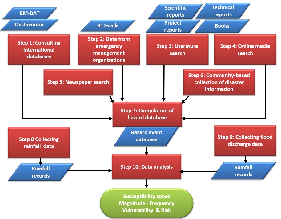
The procedure consist of a number of steps. Not all steps may be equally useful in each country.
Step 1: Consulting international databases
The first step is always to start with international disaster databases, such as EM-DAT and DESINVENTAR. Desinventar currently only has data for Haiti, Jamaica, Trinidad and Tobago, and Dominican Republic. More information can be found in the Data Management Book section 4.2. The Global Risk Information Platform (GRIPWEB) is a useful portal from where you can search for available disaster databases for your country. The Disaster Events Database maintained by CDERA contains information related to CDERA's Participating States. The information is collected from a range of sources. The database contains a limited amount of information which can be queried online. The site contains limited information on Belize, Dominica, Saint Lucia, Saint Vincent and Grenada.
Step 2: Data from emergency management organizations
The Emergency Management Organizations generally have an emergency control room, where incoming emergency calls are received and evaluated, and for emergency response. These data should be sorted, and relevant hazard-related data extracted, and stored in a database.
Step 3: Literature search
A number of studies have been carried out before on the collection of historical disaster information for the Eastern Caribbean. One of the best sources for older information is O'Keefe and Conway (1977): Natural Hazards in the Windward Islands. University of Bradford, Disaster Research Unit, Occasional Paper Nr, 14.
Step 4: Online media search
For recent events one of the best sources of information is the local online media. The information however, doesn't go back many years. Some examples are:
- Dominica: http://dominicanewsonline.com/news/entry-page/
- Saint Lucia: http://www.stlucianewsonline.com/
- Saint Vincent: http://thevincentian.com/
- Grenada: http://thenewtoday.gd/
- Belize: http://belizenews.com/
Step 5: Newspaper search
Older data on disasters should be collected from newspaper archives, which may be a tedious work. One of the best data on historical disaster events came from Saint Vincent, where someone carried out a study using newspaper records for the past decades.
Step 6: Community-based collection of disaster information
For the generation of information at the local level it is important to work together with local communities, and learn from their local knowledge. Local or indigenous knowledge is often critical in understanding the local hazard situation, as the local population has the best knowledge on the hazard events that they have experienced; their local causes and effects, and the way their community had to cope with them. After all, disaster risk reduction aims at reducing the risk of the people against disaster events, and for the implementation of sustainable disaster risk management policies the support and collaboration of local people is essential. The information is assembled through tools such as Capacity and Vulnerability Assessment (CVA), Hazards, Vulnerability and Capacity Assessment (HVCA), and Damage, Needs and Capacity Assessment (DNCA). See the following links for more information on community risk assessment tools:
- Provention consortium toolkit.
- Training manual UNDP
- IFRC Vulnerability and Capacity Assessment (VCA)
- Overview of manuals and tools by Mike McCall
Step 7: Compilation of the final database
The data that were collected from the various methods described above need to be checked carefully, and compared, in order to remove errors in relation to the date of occurrence, duplications of events reported on consecutive days, and wrong data on impacts.
Step 8: Collection of rainfall data
Rainfall data should be collected from different sources. Some of the data is maintained by the airport authorities, others by different departments. There is generally no single agency in charge of collecting and maintaining rainfall data. The available data is mostly only daily data, and many of the rain gauges only have data for a limited number of years, and data records have significant gaps in time. This requires that the rainfall data is carefully analysed and cleaned before it can be used in the analysis. More information on the collection of hydromet data can be found in the Data Management Book section 4.1.
Step 9: Collection of streamflow data
There are only very few streamflow recording stations that are operational over a longer period of time in the target countries. The stream flow stations are often installed as part of an international collaboration project, and after the project ends, there is generally no funding to maintain the stations over a longer period of time. Several of the stations have also been washed out by subsequent flood events. More information on the collection of stream flow data can be found in the Data Management Book section 4.1.
Step 10: Data analysis
Once the database has been completed it can be used as a basis for the analysis. The following types of information could be derived from such a database:
- Characterization of main hazard types in an area;
- Summarizing the impact of disaster events;
- General frequency of hazard events;
- Correlation of dates of occurrence with rainfall data;
- Spatial distributions of hazard events over the territory;
Results.
Results for the various countries can be found through the following links: