

Purpose of this document
National level soil surveys and the development of soil maps imply a significant effort and cost and are usually carried out once every several years or even decades. Therefore, it is key to define the objectives and future applications carefully and design the soil survey and products accordingly. In general, two principal types of applications can be differentiated for soil surveys: (i) agricultural use and (ii) engineering purposes. While for (i) agricultural use/agronomic purposes the focus is on soil chemistry, for (ii) engineering purposes, including slope stability evaluations, the physical characteristics are of predominant relevance. In the following the skeleton of terms of reference for soil surveys and the development of several products such as soil maps is outlined, and explanations are provided to help the reader understand the rationale for the proposed TOR components.
The document is intended then to assist readers looking for a basic structure of a ToR, however, only a suggested TOR framework is provided since for every situation more information and adjustments are needed depending on the purpose, country context etc. Each chapter first describes the type of information that could be contained, followed by blue boxes which present an example paragraph. Background information and conceptual basis on the execution of soil surveys are collected in the annex. This background information could be useful to complement the methodology recommended in the TOR, in case that the conditions of contract must be more explicit, or could serve as a point of reference to evaluate Consultant’s proposals.
This framework is understood to be applied in conducting studies on a regional (traditionally 1:10.000 or similar) or national (1:25.000, 1:50.000 or similar) scale /resolution, which result in soil maps but don’t provide enough information for local studies. Regional and national studies require a spatial handling of information and an important interpretive management that allows predicting the characteristics of the entire area and characterizing surface materials, based on a reasonable (traditionally limited) amount of field data. Products will usually be used by multiple stakeholders since they involve a wide range of information relevant for a number of sectors. Local studies (>1:5.000), for projects at a specific location, develop a more detailed and generally deeper exploration that respond to the particular requirements of the research or design of the project in question.
Terms of Reference
[Key project objective]
[Project’s name, location]
[Date]
1. INTRODUCTION
This chapter introduces the reader to the fundamental reason for the document, its function is to highlight the importance of the project and present the parties involved, from the source of funding, the client, and the stakeholders.
|
[Reference to the parties involved and direction of the project]. The support from [Funding source Institution] is aimed at providing [the Client] with financial and technical assistance to reduce vulnerability to natural hazards and climate change impacts. Among the specific aims of the project are the goals to integrate disaster vulnerability reduction and climate resilience in national development planning. One of the specific projects for integrating disaster vulnerability reduction and climate resilience is the development of a Soil Survey. The information gained in this endeavor will aid many departments across the government. There is a great need for the information that can be gained in a Soil Survey. The [Local Surveys Institution] would benefit from the information through the combining of detailed soils data with the topographic data. Updated soils information would provide a sound basis for the development of planning and zoning regulations that preserve the country’s ability to grow food and protect natural resources while guiding development in an environmentally responsible manner. The [Water Utility Institution], has a great need for the information related to the natural resources around their water catchments and how best to manage them. Farmers will benefit from obtaining detailed soils information that will help in determining which soils are suitable for which crops. Detailed soils information, including mineralogy, will provide the [Agriculture Institution] with information to provide farmers about composting, fertilizers, and their most efficient use. The [Forestry institution] would have a need for information about the relationship between soils and tree species. Detailed soil chemical, physical, and mineralogical properties will allow the [Public Works Institution] to plan, design, and construct infrastructure that is suited to the existing soil conditions. (Adapted from Reference 7) |
2. BACKGROUND AND JUSTIFICATION
This chapter aims at expressing concisely what are the contractual antecedents that motivate the realization of the analysis and soil maps, the use or central problems that will be addressed with this product, and the projection or implications that this contribution has in the future for the region or country should be made clear for the reader. This part should provide an introduction to the objectives and desired results and explain how the project intends to meet the goals and programs relevant to the client and the priorities of the funding source.
It is also useful to mention the status of the existing information, when the last soil survey was carried out and what was its scope; a subchapter can be devoted to presenting the existing database (soil classification, local land information system, current soil maps, geology, soil uses map, etc.).
This section may be used to establish the classification system that will be used in the identification of soils. If the orientation of the study is not only agrological but seeks to assist engineering purposes, not only the mineralogical and physicochemical characteristics will be required, but also the classification and properties used in the field of geotechnics.
The World Reference Base (WRB) is an international soil classification system developed with the specific aim to be globally applicable for the correlation of soils, classified in various national or international systems, and the characterization of soil profiles and soil mapping units (FAO), however numerous systems with detailed classification of soil are in existence, most of them are based on a variety of complex criteria, such as material type and properties like the amount of organic material, presence of clay layers, and the presence of oxidation or reduction iron-rich horizons, as well as depositional characteristics, its landform morphology and depositional formation processes (Cruz, 2020). In the field of geotechnics, the internationally used procedure is the “Unified Soil Classification System” specified by the ASTM norms. The TOR should recommend the standards that best fit the purpose of the project and the particularities of the region / country under study.
|
[Brief explanation of the soils at the project site and the concerns that motivate the project]. In light of these requirements, there is an urgent need for an updated and comprehensive National Soil Survey for the [Region/Country]. The ……… soils of the [Region/ Country] were first studied in a relatively detailed way in ……. Since then, a number of contemporary studies have been undertaken within the general thematic area of …………. which has added insights to the country’s soil properties. [More detailed explanation on the agrological and hydrological characteristics of the project area]. Normativity Classification in accordance to international norms such as FAO, 1988, 1998, SSS, 2003; FAO, 2006; 2014, will increase the understanding of the behavior of these soils and hence their management, ultimately leading to increased functionality and well-organized use. In this regard a number of international institutes and organizations, notably the Food and Agriculture Organization of the United Nations (FAO), the National Resources Conservation Service of the United States of America (NRCS), the European Soils Bureau (ESB) hosted by the Joint Research Centre of the European Commission (JRC), the West and Central African Union of Soil Scientists Association, and the International Soil Reference and Information Centre (ISRIC) – World Soil Information, to name only the major ones have all recognized the WRB as the official reference soil nomenclature and soil classification as the preferred tool to harmonize and exchange soil information. Landscape, land-use, and vegetation descriptions, as well as morphological descriptions will be completed in accordance with standards of the USDA-NRCS Field Guide for Describing and Sampling Soils. Physical analysis for engineering purposes must follow international standards and recognized procedures like ASTM norms. (Adapted from Reference 7). |
3. OBJECTIVES
3.1 General objectives
In general terms, soil studies allow identifying potentials and limitations to plan agricultural production/agronomic purposes or engineering projects, including risk management. In this section it needs to be clear for which of the two purposes, or for both, the soil survey would be carried out. Those orientations and their technical justification (that is, the practical reason why the project is worthwhile) should be explained to the reader.
The TOR should explain to the Consultant the use that will be given to the products, for example to analyze the effect of human activities in the soil, in order to define management measures; that may be related with the design of strategies such as minimum tillage, crop rotation, crop association, composting, irrigation control, and potential land uses. At the end, Consultant could develop for example, a soil map, a map of potential use, and a map of current use and use conflicts (use conflicts could appear for example when areas in which the recommended use should be “Protection”, to ensure that ecosystem functions are preserved, are actually used for crops. Here the social component comes to play a role. Other applications could be directed towards evaluating how much biomass is produced and how much is stopped being produced. Other assessments are related to biogeochemical cycles: carbon sequestration and oxygen generation. If any of these analyzes should be included within the study, then the TORs must clearly specify it in the section describing the scope.
It is important to emphasize that from the geotechnical point of view, a survey such as the one carried out in a project on a regional / national scale only provides information on the characteristics of the surface materials, located under the topsoil, and therefore the information it is very limited for estimating slope stability or other local applications in engineering.
The engineering parameters used in the design of safe slopes (cohesion, friction, compressibility, consolidation, shear resistance, etc.) require specialized testing that would be very costly within the context of a project like this. Explorations are also deeper than for soil maps, since the landslides and their fault surfaces generally involve deeper strata. However, geotechnical characterization of surface soils can be useful for analyzing erosion, to perform general estimates of susceptibility to landslide (making correlations with landslide inventories) and for planning of Bioengineering measures.
This chapter will have the function of establishing the minimum conditions for the elaboration of the soil survey. In this section the main outcomes of each orientation must be stated, as well as the general conditions that must be met with the products.
|
Key objective of this project is to obtain agricultural and engineering characteristics and properties in [an area of XX km2 / or name of a Country] (see Figure xx) except for built-up urban and industrial areas. Those properties will be key inputs for assessing watershed behavior, erosion, land use suitability and susceptibility analysis, particularly with respect to land slip potential, which ultimately provide data to guide long and short-term development and investment decisions. Given de scarcity of current information there is an urgent need to develop up-to-date soil datasets which will enable key stakeholders to implement land use strategies guided by edaphic information with regards to the soil’s productive capacity and limitations. With its unique climatic conditions and given the difficult challenges with regards to its very steep and finely dissected topography, which accounts for a significant percentage of the country’s productive base, the development of soil maps with soil boundaries becomes even more of an imperative in order to guide agricultural development and implement suitable management systems. The development of up-to-date soil maps is even more urgent to guide engineering activities given the complexity of [specific local soils]. (Adapted from Reference 7). Location [Example for a regional study] [Map or image delimiting study area] |
3.2 Specific objectives
In this numeral, the objectives of the different phases of the work must be stated from the preparation and design of the survey, the field work, the analysis of samples in the laboratory, definition of soil units, report, and zoning.
|
Analysis of landscape features. Soil scientist will accurately predict soil types and their associated properties using the relationships between soil and landscape features. The combination of the five soil forming factors (parent material, relief, organisms -vegetation-, climate, and time) on particular landscapes results in a unique soil (Jenny, 1941). Wilding and Drees (1978) found a relationship between a change in soil properties and landscape position. Soil identification and characterization. The origin of the soil parent material [specific local material] warrants that classification be pursued to meet agricultural and engineering objectives of soil mechanics. Understanding the mineralogical and chemical-physical differences opens up numerous opportunities in applying knowledge of these soils to important environmental issues. Develop predictive models on soil properties across the [Region/Country]. From these models, land use predictions for each landscape can be determined and provide a baseline for evaluating the impacts of management practices. Provide a database that can be used for broad planning and management, related to other land-uses in Grenada, such as parks and recreation, urban development, public services, wildlife reserves, exploitation of natural resources. Soil mapping. Throughout the [Region/Country], there exists great variability in the detail of soil pattern, produced by the very steep, finely dissected topography. Hence the recommendation from Lang (1967) confirms that mapping landscape rather than soil boundaries would give a map as valuable as the soil map for land-use planning. (Adapted from Reference 7). |
3.3 Soil maps users and stakeholders.
This chapter should refer to the agencies or institutions that require the study and the services and applications that maps, data and documents resulting from the study will have. The soil survey should be developed with the perspective of satisfying the information needs of the users that require knowledge on the soil properties.
In this section, it is also possible to indicate how the target audience would be involved in the project, for example, as providers of basic information and to guide the Consultant in the identification of local vegetation species.
Stakeholders can be involved also facilitating sites access, since for any investigation on agricultural land, coordination and cooperation will be critical. The Client, as well as stakeholder institutions should provide communication outreach with the public for several weeks prior to an area being investigated. This outreach will explain what is occurring and what the Consultant will be doing on their property, alleviating any concerns from the farmers about their land being negatively impacted. During the time of the site investigation, a local agricultural agent should accompany the Consultant during their data collection. (Adapted from Reference 7).
According to Rossiter (2004), for the soil resource, these users could include one or several of following stakeholders:
| This project is aimed to address information requirements from Land users: agricultural, forestry and livestock workers, who have the need to decide what to do with each piece of land, for example: what crop is suitable in a certain terrain, under what management system, etc. |
| Advisors and extensionists (land use planners), teachers in horticulture, forestry, soil and water conservation and environmental management, who advise the direct land users |
| Service units for the land use: agricultural credit agencies, banks, investment groups. These stakeholders facilitate the use of land and require knowing if their investment will be productive. |
|
Rural, suburban and urban land use planners, in charge of authorizing, conditioning or restricting certain uses. Environmentalists and regulatory agencies: sub-group of land use planners, but with specific authority in the regulation of land use, who use the soil as an element in the ecology of the landscape. Documentation required as basic information will be made available by the Land and Surveys Division. |
| Researchers in the reaction of the land to various types of use and management strategies. Environmentalists, who use the soil as an element in the ecology of the landscape. |
4. SCOPE
This section describes the activities that make part of the contract and the products that are expected to be achieved. The activities, including the identification of soil types, characterization, taxonomic classification, delimitation, and cartographic representation, as well as the interpretation from the point of view of their capacity or aptitude for agricultural uses, and the prediction of their behavior under different management systems must be specified.
If in addition to agricultural uses, it is also necessary to consider engineering uses or complement studies related to susceptibility to landslide, these scopes should be defined at this point with their respective implications on the depth of the study.
The scale of work and study area should be clearly delimited since these two factors are fundamental to delimit the required level of effort and costs. It is useful to also state the activities that are not considered necessary -depending on the objectives- or possible to carry out, as well as other previously established limitations.
A broader explanation of this activities can be found in the annex, such details could be included in the Terms of Reference if it is considered necessary to clarify the conditions of the study.
|
The development of the project must consider at least the activities described below for the fulfillment of the contract objectives. These activities comprise four main phases: (i) Collection, evaluation, classification, and processing of information, (ii) field surveys, (iii) information analysis, and (iv) mapping. The following numerals suggest some methodological aspects for these activities; however, the Consultant has to submit to the contract supervisor all the modifications that are considered pertinent, or propose other methodologies that meet the proposed objectives. Preparatory Phase. Prior to the start of the organized survey and mapping by the field crew, the following main activities will be carried out to learn as much as possible about the study area and to provide a sound basis for preparation of the project work plan:
Soil Survey. Purpose and extent: This component will involve conducting a detailed soil survey, at a scale of X:XXXXX for the entire [Region/Country] (except uninhabited, urban or built-up areas, industrial and miscellaneous areas like beaches, mangroves and water bodies). A survey at this scale is characterized as Order [Order] by the United States, Natural Resource Conservation Service (NRCS) and as detailed [low, medium, high intensity] according to the FAO. The purpose of this component is to map and describe in detail the soils of [Region/Country], and to make selected interpretations to assess the suitability of soils for agricultural development and for some engineering purposes. (Adapted from Reference 8) Sampling procedure. The detailed soil survey shall be carried out in accordance with the guidelines for mapping at the [Order] level of detail, as specified in the Soil Survey Manual (Soil Science Division Staff 2017a). The soil shall be mapped as single type units where possible. Because of the intricately complex topography, it may be necessary to map consociations (mixed but with one soil type dominant) or associations (mixed with several co-dominants). (Adapted from Reference 8) In general, and for agrological purposes, standard test pits at a depth of 1 meter (1x1x1) should be utilized and samples will be taken from each discreet soil horizon. For landslide susceptibility the depth of exploration depends on the depth of the topsoil, as it is the characteristics of the material below the organic soil that are of interest for engineering purposes. When possible, the Consultant will utilize erosional slides, road cuts, and auger borings as their principal form of soil sampling. Storage and Testing. These samples will be stored at [Institution] office for processing. The Consultant will be responsible for cataloging soil samples and shipping the selected samples to the appropriate laboratory for chemical and physical analyses. Soil samples that are collected, but not tested, will be stored by the [Institution] in accordance with standard techniques and held for a period of up to five (5) years for future analyses, if funds become available. Location recording. It is expected that the Consultant locate all observation points utilizing Global Positioning System (GPS) technology. Soil sampling point locations will be archived in GIS format using the [scale] topographic maps as a basis or as recommended by the [Lands and Surveys Division]. Sample locations will be projected to [locally used projection/datum, e.g. UTM, WGS84, NAD83,etc.]. Features to be collected: For each site that is going to be evaluated, the following landscape features will be collected: Weather conditions, Location (latitude, longitude, elevation), Landform (slope shape, hillslope profile), Slope and aspect, Drainage, soil moisture, ponding, and flooding information, Surface stoniness and bedrock features, Erosion and potential, Existing land use and cultural practices, Vegetation, Site photographs (North, South, East, West). The crops grown within a 15-meter radius from the test location will be described. For forested soils, trees, shrubs, and understory will be characterized within a 7.5-meter radius. This information will be critical in developing soil/plant relationships and will provide a basis for selection of species for areas that are proposed for reforestation. For human-manipulated landscapes, the land-use (e.g. house, road, bridge, etc) will be identified within a 7.5-meter radius. Basic soil morphological information will be collected, including: Depth, Horizon name, Color, Texture (class and % clay and % sand), Rock fragments (size, shape and quantity), Structure and Moist Consistence/Tilth, Redoximorphic Features, Roots, Density (measured with a pocket penetrometer), pH, Effervescence, Boundary. At each soil sampling location, the landscape, land-use, and vegetation descriptions, as well as morphological descriptions will be completed in accordance with standards of the USDA-NRCS Field Guide for Describing and Sampling Soils. Benchmark soils. The Consultant will encounter similar soils on landscapes with comparable geology, slope, aspect, moisture regime, land-use, and vegetation (see Methodology Annex). It is estimated that there will be XX to XX Benchmark Soils identified during the course of this Soil Survey. The amount of analyses required as part of this project is based on the number of Benchmark Soils identified. (Should there be 40 Benchmark Soils, 10 replicates of each Benchmark Soil and with each soil having 5 discreet soil horizons, that would include the collection of 2,000 samples). Field Physical Properties. Soil physical properties, such as: Surface permeability, Sub-surface permeability (in the most, restrictive soil horizon to the depth of investigation), Bulk Density, Penetration Resistance, will be measured in the field. The amount of surface and subsurface hydraulic conductivity measurements will be at a minimum of five (5) set of measurements per Benchmark Soil. Chemical Properties: it has been determined that the following analyses would be both of value and economically feasible for the National Soil Survey: Cation Exchange Capacity, pH, pH using NaF (Sodium Flouride), Extractable Phosphorus, Potassium, Calcium, Magnesium, Aluminum, Base Saturation, cation exchange, Soluble Salts, Organic Matter, Total Carbon, Total Nitrogen, Nitrate Nitrogen, Ammonium Nitrogen, Total Sorbed Cu, Zn, Pb, Ni, Cd, Cr, Mo For selected, Benchmark Soils, the full suite of these analyses should be completed for each soil horizon at ten (10) locations per Benchmark Soil. However, additional testing may be requested in the surface horizon(s) for all soils. Microbial Analysis. This analysis shall be completed following the procedure by Parkin et al (1996). This analysis will be completed in the surface layers of Benchmark Soils at 5 locations per Benchmark Soil. Mineralogical Analysis. It is almost not feasible to complete a wide-scale mineralogical analysis of the soil properties. There are very few laboratories in the world that complete soil mineralogical characterization (x-ray diffraction) for commercial use. Additionally, the process for determining soil mineralogy in andic soil materials is not through x-ray diffraction, but through the presence of aluminum and iron oxalates. According to the latest version of the UN-FAO World Reference Base for Soils (2014), andic properties require meeting the following laboratory criteria:
For this reason, there will be an emphasis on the determination of andic properties by using the sodium fluoride field test of Fieldes and Perrott (1966). A pH value in NaF of ≥ 9.5 indicates allophane and/or organo-aluminum complexes in carbonate-free soils. When soils meet the andic field indicator for pH values in NaF of ≥ 9.5, selected subsamples will be sent to a laboratory to verify that the soils meet the WRB criteria listed above. Should the pH values in NaF be less than 9.5, the soils will contain clay minerals that will be detected utilizing x-ray diffraction. For detailed investigation purposes XRD analysis would be completed, however, for general agrologic identification the nature of these materials is determined without performing these demanding tests. It is anticipated that there will be mineralogical analyses for at least five (5) samples per Benchmark Soil. Physical Analysis. In order to satisfy geotechnical assessments following physical properties must be analyzed: Grain size analysis (sieve analysis), Hydrometer particle size analysis, Moisture content, Atterberg Limits. The full suite of these analyses should be completed for each soil horizon at a minimum of 10 locations per Benchmark Soil. Mechanical Properties. For landslide susceptibility analysis and specific engineering purposes (sub-base of roads, residential foundations, etc.) basic mechanical properties may be necessary. In that case the Client and Consultant geotechnical engineers should define the depth of exploration (generally at depths of 1.0 m or more) and testing. In any case field and laboratory test we will be performed on soils below the topsoil, since organic materials are generally discarded for infrastructure (subgrade for roads, housing foundation, etc. (Adapted from Reference 7) |
5. CONSULTANT DUTIES
This chapter outlines the tasks in a form of a list of specific commitments and in order of execution, to emphasize the sequence. These indications may coincide with some of the steps of the methodology, however, this numeral is not intended to describe how these tasks should be developed. An example of basic responsibilities is listed below, it must be adapted to the specific project objectives and scope. For clarity of some of them see Annex.
|
6. TECHNICAL REPORT
In this numeral the Terms of Reference indicate which are the results that will be contained in the "Technical Report". Traditionally, the technical report should consist of two components, a descriptive part, in which the chapters of generalities, biophysical environment, methods and procedures, cartographic units, genesis and taxonomy are exposed and related, and an interpretative part, that present the multiple applications that the results of a soil study can offer.
|
It is required that the Selected Consultant apprise the [Client responsible team] of the status of the Soil Survey on a regular basis. This will include direct contact with [Person in charge]. The reporting requirements will include:
Additionally, there may be additional meetings requested by the [client] or the [Client responsible team] regarding the status of the National Soil Survey. |
7. METADATA AND GEODATABASE
The terms of reference should establish a structure model that the Consultant must follow for the development of metadata and Geodatabase. The Table 10 to 10 in the Annex show, by way of example, the structure adopted by the Geographical Institute Agustín Codazzi, entity in charge of soil studies in Colombia (IGAC, 2010)].
8. CONSULTANT TEAM REQUIREMENTS
This chapter specifies the level of expertise required for the development of the project. Since a soil map at the regional or national level is not frequently developed, the experience evaluation should focus on the projects that not only carry out exploration for agronomy and geotechnics but have required extrapolation and interpretation of areal information, analysis of remote images, geostatistics and geomorphological mapping.
The professional specialties of the members of the work team must also depend on the objective of the project. For engineering applications and slope stability, priority should be given to technical profiles in geology and geotechnics, for agronomic orientations the specialists in this area are the most important. GIS technicians are essential and necessary in both cases.
|
The firm must have a minimum general experience of fifteen (15) years counted from its constitution, and minimum specific experience of ten (10) contracts, executed and received to the satisfaction by the contractor, whose purpose is related to soil surveys. A thorough description of two or more contracts of soil survey projects that must be completed, or is in progress, for any government or private industry shall be documented. Also, samples or excerpts of such works shall be submitted with the bid package. The contact details (including name, email, address and telephone number) of technical representatives and contracting officers for such projects should be included. A statement and documentation shall also be included on the firm’s capabilities and facilities in supporting and related fields such as:
Minimum staffing requirements The bid package shall identify and thoroughly document the professional qualifications of all key members of the Contractor’s team, which will be provided for execution of the consultancy service. A separate curriculum vitae should be submitted for each key staff member, to include educational background, work experience and publications. Table X. Minimum work equipment requirements |
||
| Position in the project | Professional profile |
Specific experience |
| Project director, quality assurance specialist and mapping crew leader. | Bachelor*s degree (Master*s preferred) in agronomy, soil science, geology, environmental sciences, engineering, or related field. |
Experience in soil survey. Minimum experience of 15 years. much of which preferably has been with soils tropical regions. Experience with soils in the Caribbean, especially with andisols, would be a considerable advantage. Furthermore, they should be thoroughly familiar with US Soil Taxonomy and WRB (FAO) soil classification systems. |
|
Mapping Crew Members |
||
| Geologist | Geologist with higher studies in geomorphology. |
Experience in geomorphological evaluation and photointerpretation. Desirable experience in hydrogeology. Minimum of experience of 10 years. |
| Geotechnical engineer | Civil engineer with postgraduate studies in geotechnics. |
Experience in geotechnics preferably with emphasis on tropical areas. Minimum of experience of 10 years. |
| Agronomist | Bachelor’s in agronomy, agriculture and soil sciences. Experience in soil use maps for planning is desirable. |
Experience in soil survey topics like soil genesis, pedology, soil chemistry, soil physics and biology, as well as soil fertility. Previous involvement in site field studies and geospatial products. |
|
GIS and Database Development |
||
| Expert in databases and GIS. Remote sensing specialist | Systems Engineer (or civil engineer, geographer or forester) with a postgraduate degree in GIS. |
Experience statistical mapping, software development, GIS tools and programming. |
|
Supporting staff (to be locally sourced) |
||
9. PRODUCTS TO BE DELIVERED
Specify outputs, such as the types of information products to be produced, including Project Reports or items specific to the Project itself (See Annex for more details). The TOR should specify approximate dates or duration for the stages.
|
The consultant must deliver the products listed below: 1. An inception report summarizing detailed work program, personnel schedule, methodology, preliminary DTM characteristics, preliminary project components, and a draft table of content for the subsequent reports within XX weeks after the commencement of the services. This document will be submitted for approval XX weeks after the contract is initiated. 2. Inventory and evaluation of existing information and work methodology”, document duly organized according to the metadata structure and Geodatabase. The consultant must deliver the aforementioned information in print and digital media, XX weeks after the contract starts. 3. Soil Survey technical report (soil descriptions, map unit delineation, laboratory analyses) and corresponding maps in print and digital media. Thematic maps which were elaborated as result of the analysis, in a scale [X: XXXXX] with their corresponding databases in a GIS, to be submitted XX months after the contract starts. |
10. IMPLEMENTATION SCHEDULE
This section must specify the total duration of the consultancy service. A table may present a tentative breakdown of the implementation schedule for the main activities, the duration of these activities can be modified by the tenderer provided that the start and finish of the whole consultancy service are within the specified total duration.
ANNEX
Background
1. Definition of soil survey and conceptual approach.
According to Young and Dent 1980, cited by (Rossiter, 2004), the practical purpose of soil survey is to make a greater number of predictions, based on a limited number of samples and characteristics that can be collected through exploration and field work. This is the necessary research to determine the most important characteristics of soils, classify them within a taxonomic system, delimit, present them on a map and interpret them from the point of view of their suitability for agricultural, livestock, forestry, conservation, and protection purposes, with prediction of their behavior and productivity under different management systems (USDA, 2014).
The study can take the so-called geo-structural model of the geopedological approach (Figure 1) proposed and validated by Zinck & Valenzuela in different regions of the world, especially in Venezuela and Colombia (Zinck & Valenzuela, 1990).
This approach integrates three sources of information: (1) visual interpretation and digital processing of remote sensors, (2) observations and instrumental field determinations and (3) analytical determinations of mechanical, physical, chemical and mineralogical properties in the laboratory; this allows to identify, delimit and describe soil map units, depending on environmental conditions and dynamics (erosion, flooding, sediment aggradation, changes in land use, etc.). It also allows to characterize and quantify the properties of pedological materials, geomorphological formations, geological substrates and facilitates their integration into the structure of a geopedological database.
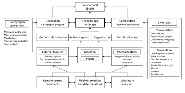
Figure 1. Conceptual model of the geopedological approach (Zinck & Valenzuela, 1990).
2. Methodology
The terms of reference may present an exposition in relation to the basic methodology that it is recommended to follow; otherwise, the Consultant firm may be asked to propose their procedures. If the TOR propose a methodology, this Annex, unlike the Duties sub-chapter, describes the minimum aspects that must be included in each phase of the study and offer bibliographic references. The following is an example of a basic methodological frame.
For the development of the soil survey, the Consultant should accomplish the basic stages listed below.
- Preparation of the survey
- Definition and characterization of variables
- Preparation of the preliminary zoning maps and survey’s legend
- Field work and sampling
- Laboratory analysis
- Data interpretation and presentation
- Data Management. Development of the Metadata and Geodatabase and final reports
- Preparation of final reports.
1) Survey preparation and planning
This activity consists at least of the following sub-activities:
a. Compilation, classification, and analysis of secondary information
This activity includes the acquisition, compilation, review, and analysis of thematic and cartographic secondary information in order to organize a useful database for carrying out the activities and inform the characterization analyzes. To facilitate the organization of the information, the consultant should fill out forms that can be provided by the client with standardized tables for information gathering.
b. Selection of cartography and reference system
Basic cartography is understood as the topographic map, whose location coordinates have to be duly referenced and projected according to the type of coordinates established in each country.
The topographic base selected to represent the soil survey should include contour lines, housing location, hospitals, schools, government offices, and vital lines, etc., information that should have been generated by official entities responsible for country cartography.
c. Planning the density of exploration and minimal unit of area to be mapped
The planning of the exploration density should be based on the interpretation of the existing information in relation to the land cover, vegetation, geomorphology, and the analysis of the different edafogenetic environments, giving rise to an approximate physiographic map that anticipates the location and extension of homogeneous units. The ease of entry, the access roads and the security of the region must also be taken into account.
Observations can be distributed in transects (located on straight lines perpendicular to the delineated geoforms), rigid network (Figure 2) (grid distribution at a predetermined distance depending on the scale), flexible network (variation of the rigid network , with distribution at the discretion of the group of professionals), in an oriented way, or through the free mapping system (at the discretion of the group of professionals) having a density that allows delimiting the soils or soil cartographic units at the required scale.
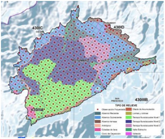
Figure 2. Distribution of observations in rigid network (IGAC, 2016)
The density of exploration in each of these units must be planned according to the scale or resolution specified in the objectives of these Terms of Reference and following the national standards.
In case that there are no institutionalized national standards to define the scale and the minimum mapping area according to the objective, the Consultant could follow the criteria established in Table 1. In any case, the number of observations should be an average, from ¼ to 1 field observation per cm2 of map, that is, each observation represents 1 to 4 cm2 of the final map.
Another proposal is the one formulated by Rossiter (1994), in which the precision will be given by the relationship between the minimum decision area (MDA) and the optimum legible delineation (OLD) of a map, converted to real scale as indicated in Table 2.
| MAP SCALE | MDA (ha) | OLD (ha) | SAMPLING DENSITY (m) |
| 1: 10000 | 0.4 | 1.6 | 64 - 128 |
| 1: 25000 | 2.5 | 10 | 128 - 316 |
| 1: 50000 | 10 | 40 | 316 - 632 |
| 1: 100000 | 40 | 160 | 632 - 1264 |
| 1: 500000 | 1000 | 400 | 3162 - 6324 |
Table 1. Scale and minimum decision area (MDA) corresponding to the optimal legible delineation (OLD) and sampling density. (Adapted from Rossiter, 1994).
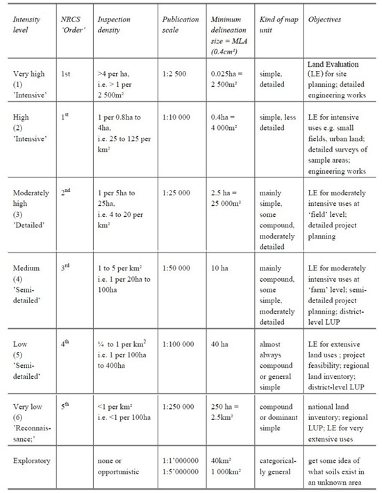
Table 2. Level of intensity of the survey (Avery, 1987).
In determining the appropriate sampling density and therefore the scale for this Soil Survey, it is also recommended a previous differentiation of zones based on uses (urbanized areas/cities, agricultural producing areas, rainforest areas), vegetation, geomorphology, etc. When the orientation of the study is agrological it is also worth considering slope classes (see Table 3) as prime agricultural soils are located in less sloping areas, and also considering that from a physical effort perspective, more samples can be collected on less sloping land.
Table 3. Soil Sampling Density by Slope. Table for calculation of sample points number
(Adapted from Reference 7)
| Slope Class (%) | Total Hectares | Sampling Density | Total Sample Points |
| 0 - 8 | 1 observation/10 ha | ||
| 9 - 15 | 1 observation/100 ha | ||
| 16 - 25 | 1 observation/100 ha | ||
| 26 - 40 | 1 observation/1000 ha | ||
| 41 - 60 | 1 observation/1000 ha | ||
| >61 | 1 observation/1000 ha | ||
| Total | 1 observation/81.4 ha |
If the exploration is directed to inform studies of landslide susceptibility, it is particularly important to describe the soils of steep slopes, documenting especially the soil thicknesses, since those superficial layers are more prone to landslides and the lower parts of the slope are exposed to be buried in a mass movement event.
Another perspective on determining soil sample density is to utilize land-use categories. In consideration of the various land uses, differing densities can be determined for each land-use type. An example of such densities is included in Table 4.
Table 4. Soil Sampling by Land-Use. Example table for calculation of sample points number. (Adapted from Reference 7)
| Land Use | Total Hectares | Sampling Density | Total Sample Points |
| Elfin Alpine Meadow | 1 observation/10 ha | ||
| Littoral Woodland | 1 observation/100 ha | ||
| Mature Rainforest | 1 observation/500 ha | ||
| Montane Rainforest | 1 observation/500 ha | ||
| Montane Thicket | 1 observation/100 ha | ||
| Savannah and Grazing Lane | 1 observation/10 ha | ||
| Scrub Woodland | 1 observation/100 ha | ||
| Secondary Rainforest | 1 observation/500 ha | ||
| Urban | 1 observation/1 ha | ||
| Total | 1 observation/82.9 ha |
Previous analysis of the geomorphology and in general of the basic information is extremely useful to plan the sampling. Soils of volcanic origin, for example, are usually very uniform, so large areas can possibly be characterized with less sampling. Geomorphology, geology, and statistical calculations allow extrapolation of results between sampling sites. Vegetation, which is very indicative of continuity of soil types is also useful.
If the exploration is directed to inform studies of landslide susceptibility, other categories like bare ground and rock-face areas (which would not have greater relevance from an agrological point of view) would be very important, since they must be characterized with respect to their propensity to erosion and rock fall.
d. Digital Elevation Model
For soil survey the Consultant should use a DEM with the best spatial resolution available for the study area. Ideally, and if resources are available, the Consultant should use LiDAR imagery, since this technology allows to directly measure the height and density of vegetation on the ground and offers the best resolution to capture slope and other geomorphological features. Regarding pay for use products, there are public and private vendors who are creating new high-quality datasets worldwide, including height values acquired from high-resolution satellites, and land usage classification based on sensors. Some of them are AW3D, AIRBUS, PlanetObserver. See Table 5 for a comparison of some of their products.
Table 5. Some chargeable DEM sources (https://www.l3harrisgeospatial.com/Data-Imagery/)
| AW3D | AIRBUS | PlanetObserver |
|
AW3D Standard Resolution: 5m |
AIRBUS WorldDEM Resolution: 12 m post spacing |
PlanetSAT 15m Imagery Basemap Resolution: 15m grid spacing Vertical Accuracy: Down to 1:50,000 Sources: Landsat 8 for 40% of the world, Landsat 7 Projection: Geographic Datum: WGS 84 Format: GeoTIFF, ECW |
If no detailed DEMs are available and resources are limited, DEMs from ALOS and SRTM satellites can be used for intermediate work scales (with resolutions between 12.5 and 30 m per pixel, which allow to have that spacing between contour lines) since they have very good coverage (see Table 6 Figure 3). For some regions even, there are now LiDAR datasets available at no cost, so it is worth checking one of the following sources: Open Topography (https://opentopography.org/), USGS Earth Explorer (https://earthexplorer.usgs.go), United States Inter-Agency Elevation Inventory and NOAA Digital Coast (for USA), National Ecological Observatory Network - NEON (https://data.neonscience.org).
In identifying the most appropriate source of information, it is important to remember, in addition to the level of detail, that DSM includes features such as vegetation and man-made structures, while a DTM will have the surface features removed so it represents bare earth; and that RGB chromatic satellite images (such as those obtained from Landsat and Sentinel) and the combination of them allow to interpret aspects such as vegetation, land uses and bodies of water.
Table 6. Freely available DEM data sources. (https://yceo.yale.edu/major-dem-sources)
| Source Type | Geographical Region | Spatial Resolution | Notes | Source Link |
| National Elevation Dataset (NED) | U.S., Puerto Rico, Territorial Islands of the U.S., and Mexico | 1 arc-second (30 m) 1/3 arc-second (10 m) 1/9 arc-second (3 m) 2-arc-second (60 m) – only Alaska |
Most preferred for continental U.S. | The National Map Viewer |
| Suttle Radar Topography Mission (SRTM) | Global Global U.S. |
3 arc-second (90 m) 1 arc-second global 1 arc-second for U.S. |
Version 2: finished Version 3: Void fill Version 3 |
USGS Earth Explorer Reverb | Echo for Version 3 |
| ASTER Global Elevation Data (GDEM) | Global | 1 arc-second (30 m) | Only between 83ºN and 83 ºS | USGS Earth Explorer |
| Global Multi resolution Terrain Elevation Data 2010 (GMTED2010) | Global | 30 arc-second (1 km) 15 arc-second (450 m) 7.5 arc-second (225 m) |
Replaced GTOPO30, preferred for working with very large regions | USGS Earth Explorer |
| JAXA’s Global ALOS 3D World | 30-meter | The most precise global-scale elevation data |
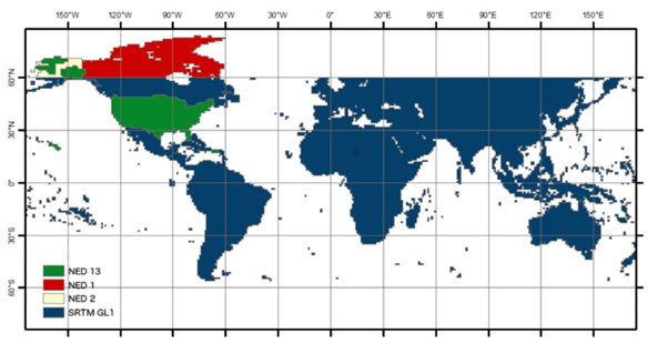
Figure 3. Geographic coverage of the SRTM1 DEM. Source: ASF (2015)
2) Definition and characterization of variables
a. Climate
Climate, fundamental quality of a territory, has a direct impact on the physiology of plants and directly affects the process of photosynthesis and therefore the growth, production and quality of crops. On the other hand, from the geotechnical point of view, climate is a determining factor in the degree of weathering of soils, which transcends in their mechanical behavior. Therefore, the Consultant has to collect, process and analyze historical data available from the weather stations in the area to be evaluated (statistics and temperature averages, precipitation, evapotranspiration, solar brightness, wind speed and direction, relative humidity, etc.).
If the coverage of climatic stations in the study region/country is not sufficient, the consultant should resort to data from stations located in the area of influence or to data surfaces generated by interpolation of national or global data or models (WORDCCLIM, CHIRPS), provided by research centers national or international. The result of these analyzes should allow generating homogeneous zones in terms of precipitation, altitudinal floors associated with temperature that limit the number of land uses.
b. Geology - Surface Geological Units
The Consultant should compile - if the information from local institutions is available- or perform the identification of the geological units based on photointerpretation, survey, and field verification, emphasizing surface geological units. As a result of the characterization, geology maps should be prepared that contain information on the lithology of the materials (rocks or soils), their origin, structural disposition, physical and mechanical characteristics, hydrological and hydrogeological characteristics, among others.
As an example,
Table 7 and Figure 4 indicate the surface geological units and a methodological flow chart used by the Colombian Geological Service (SGC, 2017).
| TYPE OF MATERIAL | ORIGIN OF THE GEOLOGIC UNIT | TYPE OF GEOLOGIC UNIT | |
| Rock | Unaltered rock |
|
|
| Soil | In situ rock derivatives |
|
|
|
Transported soil. |
Primary volcaniclastic deposits |
|
|
| Secondary volcaniclastic deposits |
|
||
| Alluvial deposits |
|
||
| Lacustrine and paludal deposits |
|
||
| Coastal deposits |
|
||
| Eolic deposits |
|
||
| Glacial deposits |
|
||
| Gravity and slope deposits |
|
||
| Anthropic deposits |
|
||
Table 7 Surface Geological Units (SGU) according to their origin.
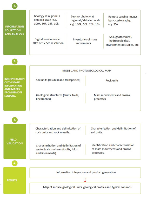
Figure 4. Activity flowchart in the generation of the map for Surface Geological Units.
c. Geomorphology
The geomorphological analysis should emphasize the identification of geomorphological processes, units and subunits, both of endogenous origin and of exogenous origin. For this, the analysis must be carried out under three main components: the morphology that differentiates the landforms by their genesis or origin, the morphometry that quantifies or measures the landforms and the morphodynamic that identifies, classifies, characterizes and zonate the different past and recent dynamic processes.
d. Slope
The slope is a characteristic that allows, in an approximate and preliminary way, to characterize surface materials in terms of mechanical characteristics.
As in the definition of the scale and minimum area, if there are no slope ranges classified in previous studies, the consultant may use the slope ranges proposed and validated by Van Zuidan, which are indicated in Table 8.
| INCLINATION | CHARACTERISTIC PROCESSES AND GROUND CONDITIONS |
| 0-2 | Flat or almost flat. There is no appreciable denudation. |
| 2-4 | Gently inclined. Low speed mass movements and different types of erosive processes, especially under periglacial (solifluxion) and fluvial conditions (laminar and rill erosion). Susceptible to develop erosive processes |
| 4-8 | Inclined. Similar conditions to the above. High susceptibility to develop erosive processes. |
| 8-16 | Moderately abrupt. Mass movements of all types, especially periglacial solifluxion, creeping and occasionally landslides, also laminar and rill erosion. Susceptible to erosion and landslides |
| 16-35 | Abrupt. Intense denudational processes of different types (erosion under forest cover, creeping, landslides). High propensity to develop erosive processes. |
| 35-55 | Very abrupt. Rocky outcrops. Intense denudational processes, thin chaotic granular deposits. |
| >55 | Extremely abrupt. Rocky outcrop. Very strong denudational processes, especially "scarp denudation"; susceptible to rock fall. |
Table 8. Slope ranges used for engineering purposes and landslide hazard zoning in Colombia. Von Zuidam (1986)
It should be noted that the classification shown in Table 8 is just an example showing a typical differentiation; in regions with volcanic soils, care should be taken to develop classifications based on local experience. This is because many volcanic ash soil formations are more stable at slopes close to the vertical and paradoxical unstable at gentle slopes.
e. Land cover and land use
Other relevant variables in the study of soils are land cover, land use, and changes over time, either due to anthropic causes (deforestation, intensive use of the soil, etc.) or natural causes (forest fires, soil removal, among other). Therefore, the consideration of this variable should involve a multi-temporal analysis of the changes in coverage and current land use. As an example, Figure 5 shows the methodological flowchart used by the Colombian Geological Service for this variable.

Figure 5. Methodological flowchart for the generation of the variable land cover and land use, used by the Colombian Geological Service.
3) Preparation of the preliminary zoning map and legend
Preliminary zoning maps allow the results of the analysis of basic information and remote images to be captured, as well as the geomorphological analysis, thus allowing the approximate anticipation of areas that will probably have different types of soil. These maps can be dedicated to various topics according to the information collected: geology, parent materials, geomorphology, (landscape, type of relief, landform, climate, vegetation, cover and land use. Planning the distribution and density of exploration based on this map can avoid making mistakes, making unnecessary investments or overlooking important aspects in the field work. Figure 6 shows an example of a preliminary zoning map.
Figure 6. Preliminary map for distribution and location of field observations based on landforms. (IGAC,2016)
The Consultant must prepare the preliminary legend of maps, which should include aspects related to climate, geomorphology, (landscape, relief type, lithology / sediments and terrain shape), and morphometric characteristics of the landforms and type of relief, and the symbols that will identify each delimited unit.
The cartographic units should be identified with a symbol consisting of two uppercase letters and one or more lowercase letters. The first two letters indicate the vernacular name of the unit and the following indicate the cartographic phases adopted in the study. To name cartographic units, local names should be considered accompanied by the subgroups and the respective families. The cartographic symbol must be represented by two uppercase letters, followed by one or more lowercase letters and sometimes an Arabic number.
4) Fieldwork and sampling
The field survey must be carried out strictly following what was established in the previously performed exploration design and the project supervision criteria.
The following minimum kinds of information shall be described at all observation sites in field notes: profile number, soil profile description status, date, author(s), location, elevation, map sheet number and grid reference, land form, position within the landscape, rock outcrops, surface fragments (stones), micro-topography, soil erosion, signs of surface litter, faunifacts, effective rooting depth, parent material, land use (including description of vegetation or crop cover), and evidence of human influence or disturbance. The topographic examination should particularly look for old scar faces, slump bulges, and other signs of previous mass movement.
The bulk of observations ( for example 75%) will be made by auger boings to an approximate depth of 1.0 m or to the top of the indurated layer, whichever is shallower. The boring must be deep enough to observe one or more distinguishing feature about the soil to permit confident classification to the series level.
During the fieldwork, the profiles should be tentatively classified up to the subgroup and class level, according to the particle size, in accordance with the rules of the American Taxonomic System (Soil Survey Staff, 2010). In any case, the number of observations should be enough to identify the soils in the existing edaphogenetic environments.
Deep augerings could be made to identify potential shear zones in lower subsoil and upper regolith. The distribution of deep augerings should be based on exiting hazard maps, landslide registry or related historical records.
These auger observations will be made at regular intervals along transects lines to confidently determine the composition of representative map units and the proportional extent of each taxon represented in each mapping unit. A minimum of, for example, 5 transects, each consisting of 5 or more points, will be made for each map unit. Transects will be uniformly distributed throughout the area of occurrence of each map unit.
For each taxon recognized and mapped, complete pedon descriptions will be made from a minimum of 10 purpose-dug profile pits or in existing free-face exposures, such as road cuttings. Where cuttings are used, the face needs to be cut back by at least 50 cm. The profile should be at least 1.5 m deep or 30 cm below the top of cemented or indurated layers or to bedrock, whichever is shallower. A more detailed classification could reveal still a greater number of soil series; however, a conservative estimate of the minimum number of profile pits and free-face exposures should be specified. The soil should be described by natural horizons for: matrix colour, mottles, hand texture, consistence, stoniness, soil structure, porosity, rooting and faunifacts.
Particular care is necessary to identify signs of buried soils (darker colours, crumb structures, dense rooting) as these could be due to local slope instability. Also, seepage zones that are wetter than above and below may be potential shear planes and indicate susceptibility to slope failure. Layers with unusually high density of rooting compared with above and are probably wetter and may be potential shear zones. (Adapted from Reference 8)
5) Laboratory analysis
Representative samples of the soil horizons collected during the survey shall be subjected to complete physical and chemical analyses so as to thoroughly characterize the soils and to classify them according to the FAO World Reference Base. The number of samples to have complete analyses will depend on the number of soil reference groups or taxon identified. Samples from at least one representative pedon for each identified taxon will be analyzed. In addition to these analyses, samples of selected horizons may have to be subjected to certain analysis in order to answer specific questions pertaining to classification or behavior. (Adapted from Reference 8)
To carry out the different chemical, physical and mineralogical analyzes of the samples collected in the field, the methodologies established and used by the National Soil Laboratories of each country must be followed. In case there are no official laboratories (designated by the central competent authority), the tests may be carried out in private accredited laboratories, certified by the National Organizations.
The type of analysis and the method to be used should be agreed upon with the supervision of the study; In any case, the results of the laboratory analyses should allow obtaining the final taxonomic classification at the soil family level.
There is a wide range of field and laboratory assessments used in agronomy to characterize soils, the tests specified in the TOR must be adapted to local needs and the objective of the study, however there are a series of basic parameters and interpretations that should always be studied to achieve useful product:
Physical Parameters usually determined for geotechnical classification
- Particle size distribution.
- Soil moisture
- Percentage of sample passing the sieves numbered 4, 10, 40 and 200.
- Liquid limit
- Plasticity index
- Unified Soil Classification System (USCS) engineering classification
Physical Parameters for specific engineering purposes
- Soil surface fragments larger than 75 mm
- Colors, mottles, and consistence for wetted soils as well as in the field moisture state.
- horizon faces in each main horizon profile
- Shear strength measured by a shear vane and resistance with a penetrometer at multiple points on cuts
Physical Parameters for agronomic purposes
- Bulk density using undisturbed core samples: soil compaction may change due to changes in land use. This has implications for root growth and water movement through the soil, an also restricts the growth of vegetation. This variable is related to porosity, the smaller the pore space, the fewer is the ventilation and less water flow. It can then be associated with the interaction between soil, water, and plant.
- Drainage: generally rated on a scale of “bad, good and excessive”. It is done by field observation.
- Infiltration: also associated with the interactions soil - plant – water.
- Conductivity: allows to assess if there is soil salinization, which is a common effect in soils under irrigation in areas where rainfall is low and there is no sufficient depth of water to wash the salts from irrigation. This is one of the previous steps to desertification.
- pH: It may be reduced in the case where the rain washes nutrients because the soil was left exposed, for example in case of clean crops. Acid soils restrict crop development because they have problems with the absorption of nutrients, especially phosphorus, and because of the toxicity of elements such as aluminum.
- Structural stability: with this parameter you can evaluate the susceptibility to erosion of the soil surface.
- Organic matter content: which is related to the density, porosity, and fertility.
- Activity of microorganisms: which should be evaluated from the functional groups such as: nitrifying bacteria, phosphorus solubilizers, etc.
- Fertility analysis to determine content of nitrogen, phosphorus, potassium, magnesium, calcium, and microelements.
- Texture and structure
- Soil moisture at 1/10, 1/3, and 15 atmosphere tensions (it is however not determinant for taxonomic classification).
Chemical properties for agronomic purposes.
- pH in water saturated soil extract
- Organic carbon and organic matter content
- Total N
- Carbon/Nitrogen ratio
- Exchangeable cations by pH buffered 1M ammonium acetate leaching (includes potassium, calcium, magnesium, manganese, sodium)
- Cation exchange capacity (CEC) by NaCl leaching and NH4 distillation
- Extractable Al by leaching with 1M KCL
- Crystalline and labile free oxides of iron and aluminium extracted by oxalate and diothionite extractions
- Total nutrients extracted by N Carolina tri-mineral acid mixture
- Clay mineral identification in samples from three different depths of each representative profile of the most extensive soil identified.
- Andic properties and particularly allophane content should be determined by the pHNaF test (Fieldes & Perrott 1966). [Properties for the identification of soils of volcanic origin].
Some parameters are more specialized, their determination is more expensive and they are not decisive for the classification, such as Available phosphorus (Troug/ Mehlich 3)
Many soil properties can change as a result of management, historical land use or even natural factors, such as climate change exacerbated by heavy rainfall events, landslides, drought, interacting with land use. National soil survey databases traditionally include soil property information for the relatively static soil properties, such as texture, and also for properties affected by management, such as soil organic matter. The databases do not normally distinguish the values of dynamic soil properties (e.g., organic matter, bulk density, infiltration rate) according to their land use, management system, ecological state, or plant community. (Adapted from Reference 8)
For the purposes of this assignment, “Dynamic soil properties” are defined as soil properties that change within the human time scale. Differences that may exist in these properties can affect the performance of the soil. Information about what changes and what can recover is crucial for achieving short- and long-term soil management goals and maintaining soil quality (Tugel, A. 2008)
Special considerations for volcanic ash soils
The soils in Dominica are unique with the steep contrast between minimally and highly weathered parent materials. On large portions of the island that consist of young materials, formed in volcanic materials (Andosols). According to the Soil Science Society of America, these soils are generally fertile due to their high capacity to hold both nutrients and water. However, these soils have low phosphorus availability due to the presence of the amorphous clays (e.g. allophane, imogolite, halloysite). These clays pose a significant challenge for both physical and chemical analyses.
On stable landscapes, given the warm temperature and moist climate, there is rapid weathering of the clays and low-activity clays predominate (Ultisols and Oxisols). These soils are generally not fertile with few cations present with the exception of aluminum; phosphorus availability in these soils is also low as allophane binds it and renders it unavailable for plant uptake. These clays pose an additional set of challenges as some analyses are suited to soils within a specific pH range and these soils are often below this pH range.
There are specific methods to determine the presence of andic properties; these methods include the following:
World Reference Base (WRB)
- Acid oxalate extractable Al + 1/2Fe oxalate values of 2.0% or more
- Bulk density of 0.90 kg/dm3 or less
- Phosphate retention of 85% or more
- Less than 25% organic carbon
Soil Taxonomy (U.S.)
Same as WRB, except that it allows for an additional set of criteria:
- 30% or more of soil particles are between 0.02 and 2.0 mm in size
- Phosphate retention of 25% or more
- Acid oxalate extractable Al + 1/2Fe oxalate values of 0.4% or more
- Volcanic glass content of 5% or more
In discussions with laboratories in the United States (USDA-NRCS Kellogg Laboratory in Lincoln, NE) and other countries with substantial areas of volcanic soils (Korea, New Zealand), it is not practical to complete these analyses for every soil sample.
To determine the presence of andic materials, both field analysis and completion of pH tests in sodium fluoride (NaF) will first be utilized as a screening tool. In the field, the presence of andic materials can be observed through the morphological soil description as well as during texturing. Given the stark contrast between the relatively young andic soils and the much more weathered soils with low activity clays, identifying andic materials in the field should be feasible to complete.
Soils that formed in volcanic soil materials presented many problems in the analysis of physical characteristics. The amorphous clays behave differently upon drying and subsequent re-wetting, as is common in physical analyses. Consideration of the soil mineralogy must be considered when completing these analyses.
The laboratory analysis of andic materials must be completed in accordance with the procedures of Field and Perrott (1966). A pH value of greater than 9.5 indicates the presence of andic materials.
Fieldes, M., Perrott, L.W. 1966. The nature of allophane in soils. III. Rapid field and laboratory test for allophane. New Zealand Journal of Science. 9: 623-629.
There are other methods to determine the presence of allophane as well, such as the toluidine blue test. While not referenced in the WRB database, this method has been proven to be effective.
Koji Wada & Yasuko Karwto (1985) An Evaluation of the Toluidine Blue Test for the Assessment of Allophane and Imogolite, Soil Science and Plant Nutrition, 31:3, 383-389.
When soils meet the andic field and pH indicators, selected subsamples will be sent to a laboratory to verify that the soils meet the WRB criteria listed above.
(Adapted from Reference 7)
6) Data interpretation and presentation
After final delineation of the map units, a thorough description of each unit shall be presented in either narrative or semi-tabular format. Guidance on preparation and presentation of soil survey interpretations is given in Part 617 of the National Soil Survey Handbook (Soil Survey Staff 2016). The map unit description should include the following minimum kind of information: map unit name, slope range, setting on the landscape, climatic setting, percent composition of named components and included soils not part of the map unit name (soil series or taxa above soil series), popularized description of each soil given in the map unit name, erosion and landslide hazard, ground cover description (including commonly cultivated crops) and a brief listing of management concerns and needs. (Reference 8)
- Classification and legend of land use capacity
The legend on use capacity for soil studies should contain the following criteria: class, subclass, management group, cartographic units of soils, main limitations of use, recommended uses, management practices, extension (ha) and percentage of participation within the study area. By way of illustration, Table 9 presents a legend model structure adopted by the Rural Agricultural Planning Unit of Colombia (UPRA, 2014)
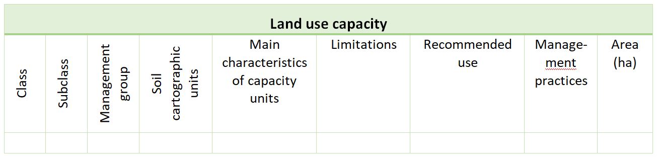
Table 9. Legend for classification of soil use capacity
For the grouping of soils by their capacity of use, the consultant should select the modal profiles in each of the cartographic units of soils and for each of the profiles evaluate the following: erosion, slope, texture, effective depth, surface stoniness, flood potential, fertility, aluminum saturation, acidity, alkalinity, drainage, and climate. The Consultant should perform the comparison and qualification of the selected characteristics in each modal profile with the classification tables and the determination of the classes of use capacity, according to the degree of the dominant general limitations.
Land use capacity subclass denotes the main physical limitation or hazard for a piece of land. Four limitations are recognized: erodibility (e.g. mass movement, gully, rill, wind), wetness (e.g. high water table, slow drainage, flooding), soil (e.g. shallow soil, stoniness, water holding capacity), climate (e.g. dry, wet, frost/snow).
The subclasses should also be established according to the number of limitations; the Consultant have to prepare a correlation table of the soil units with the subclasses, prepare the classification legend of the soils by use capacity, describe each of the soil units by use capacity and represent it by means of a symbol formed by Arabic numbers, letters and lowercase letters, as indicated above. The first number indicates the class by capacity, the lowercase letters represent the subclass and the Arabic number that continues, separated by a hyphen, is related to the management group.
7) Data Management. Development of the Metadata and Geodatabase and final reports
To ensure effective and optimum utilization of the large database that will be generated from the soil survey, a computer-based soil information system (SIS) shall be developed to provide an efficient and useful environment for handling and managing the soil related data. The SIS will comprise a database management system (DBMS) interactive with GIS. The SIS shall be developed and operationalized to:
- Input, analyze, manage, and display various kinds of geographic and nongeographic information,
- Relate information about soil properties and identify, using statistical methods and indicators, current and possibly future problem areas.
- Support the evaluation of soil classes with respect to land suitability for agriculture ((FAO 1976) and engineering soil uses erosion hazard, irrigation, drainage, and other criteria,
- Produce information related to individual survey mapping units and produce interpretative maps at different scales,
- Provide support to produce and display general maps of the study area in graphical and imagery formats showing the various distribution of soil classes at different scales,
- Provide interactive displays and reports about soil class characteristics and other associated information to be used for soil management and planning, and
- Delineate, display and identify areas of potentially agricultural soils and soils best suited for infrastructural development, at different scales.
All of the field, laboratory and graphic data, and other related information, acquired during the survey shall be synthesized and analyzed. Several interpretations of the mapped phases of each soil series in the survey area shall be generated to show the potentiality and limitation for agriculture as well as engineering uses. Rating criteria and suitability classes for agriculture and engineering will be guided by Chapter 8 of the USDA Soil Survey Manual (Soil Science Division Staff 2017b). Other suitable methodologies may be recommended and used by the contractor. Modifications to available interpretation models may be necessary to ensure compatibility and usefulness for local conditions. These are acceptable providing there are plausible explanations and justification. (Adapted from Reference 8)
The following are examples of metadata structures used by the Colombian Geological Survey in a SIS.
| METADATE STRUCTURE | ||
| FOLDER | SUB-FOLDER | SUB-FOLDER |
| Project's name | Capacity | |
| Geomorphology | ||
| Memories | ||
| Soils | Documents | |
| Geodatabase | ||
| Supplies | ||
| Mxd files | ||
| Traceability | ||
| Zoning | ||
Table 10. Structure of soil survey metadata
| GEODATABASE STRUCTURE | |
| GEODATABASE | LAYERS |
| Project's name | CARTOGRAPHIC UNITS OF SOILS |
| MODAL PROFILES AND INCLUSIONS | |
| USE CAPACITY | |
| LAND ZONING | |
Table 11. Structure of the soil survey Geodatabase
| LAYER STRUCTURE | ||
| SOILS | CAPACITY | ZONING |
| CSU (Cartographical Soil Unit) | Class | Offer |
| Phases | Subclass | Primary use |
| Landscape | Management group | Characteristics |
| Weather | CSU_ Capacity | Voc Zoning (Vocation of use) |
| Relief Type | Characteristics | Area ha |
| Terrain Shape | Limitations | |
| Parental Material | Recommended uses | |
| Characteristics | Area ha | |
| Taxonomy | ||
| Profiles | ||
| Percentage | ||
| Area ha | ||
Table 12. Structure of the soil survey layers.
8) Preparation of final reports
A draft soil survey report including all the necessary maps, texts and illustrations shall be submitted to the client, at least (3) months after conclusion of the field survey. The client will provide, written comments to the Contractor for consideration in preparing the final version.
The report shall include, but not necessarily limited to, the following:
- An introductory section explaining the purpose of the survey, starting, and finishing dates, survey methodology and background information.
- A general description of the study area including geographic location, size of survey area, physiography, geology, geomorphology, native vegetation, climate, natural drainage, wildlife, present land use, water resources, settlement, and communications.
- Descriptions of the individual soil taxonomic and map units (shown on the maps) supplemented with tables showing their characteristics, relationships and the associated landform, parent material, vegetation, and land use features.
- Predictions of the yields of the common crops of the areas under different sets of management practices for agriculture (particularly crop production),
- Interpretations of soil phases for several uses, including suitability for agriculture and non-agriculture (engineering) uses with reference to standards and specification for the selected order /detail level of soil survey.
- Discussion of the soil formation process, genesis and controlling factors of the different soil types in Grenada.
- Certification statement
- Signature of approval from soil surveyor/soil scientist
- Outline of proposals for applied research projects on soil related problems that require further investigation.
- A set of maps including (as a way of example)
- Detailed soil maps of study area at the required scale
- Land use maps at the required scale.
- A set of interpretative maps at required scale, showing the suitability classes for agricultural uses (according to FAO soil capability with requisite modifications for local conditions) (FAO 1976) and for engineering uses according to the Unified Soil Classification System (ASTM 2006; Howard 1986; USDA 1990)
The cartographic guidelines for soil map compilation, soil map finishing, and soil map digitizing outlined in the USDA-NRCS National Soil Survey Handbook, Part 647 - Soil Map Development, should be followed (Soil Survey Staff 2016). The basic procedures and principles outlined therein to ensure quality control and assurance of the mapping process shall be adopted. High accuracy standards are required because of the need to accurately locate relatively small areas of soil, and because the soils map features will be digitized for use with other geographically controlled maps in GIS.
The other following points shall be observed in the production of the photo- or image-based soil maps:
- All map unit boundaries shall be closed
- Each map unit shall have the correct map symbol
- The boundaries and symbols on each map shall be consistent and join those on adjacent maps
- Each map shall show sufficient features (roads, cities, villages, coordinates and other prominent sites, etc.) to facilitate the location of map units on the ground, and
- The printed maps shall match each other in tone and density of color.
Other documentation
In addition to the reports and maps mentioned above the Contractor shall also provide the client with the following:
- All field notes, including all pedon descriptions, transect notes and original field map photos and topographic sheets (these items are to be arranged and filed by an orderly and readily retrievable manner; detailed pedon descriptions to be filed by soil series, informal notes about pedons and map units to be filed by soil series, informal notes about pedons and map units to be filed by map unit, and field soil survey photos and sheets are to be arranged in sequence with an appropriate and legible photo and map index).
- All original laboratory test sheets and forms filed by soil series
(Adapted from Reference 8)
1. LITERATURE REFERENCES
Please note that most of the bibliographic sources are referencing universities and organizations based in the United States, some methods must be proved and adapted when characterizing tropical soils, especially when handling andic, partially saturated and highly weathered soils.
- Rossiter 2000. Methodology for Soil Resource Inventories. Soil Science Division International Institute for Aerospace Survey & Earth Sciences (ITC).
- van Zuidam, R. A. (1986). Aerial Photointerpretation in Terrain Analysis and Geomorphological Mapping. Tha Hague: Smiths Publishers.
- Servicio Geológico Colombiano (SGC) 2017. Guía Metodológica para la Zonificación de Amenaza por Movimientos en Masa a escala 1:25.000
- Soil Survey Staff. (1993). Soil survey manual. US Department of Agriculture Handbook 18. Washington DC: US Gov Printing Office.
- Zinck, J. A. (2012). Geopedología: Elementos de geomorfología para estudios de suelos y de riesgos naturales. (ITC, Ed.) Enschede: ITC Special Lecture Notes Series.
- Zinck, J. A., & Valenzuela, C. R. (1990). Soil geographic database: structure and application examples. ITC Journal, 1990(3), 270-294.
- Terms of Reference National Soil Survey Commonwealth of Dominica
- Lloyd, Davidson. 2018. EcoApp Inc. Consultancy Services for the Design and Development of Specifications and Scope of Service for, and Supervision/Quality Control of Soil Survey.
- USDA-NRCS Field Guide for Describing and Sampling Soils.
- Instituto Geográfico Agustín Codazzi - IGAC (2016). Etapa post-campo para los levantamientos de suelos. Nov 2016. and Preparación, actualización y análisis de la información en la etapa precampo para levantamiento de suelos
- Schoeneberger, P.J., D.A. Wysocki, E.C. Benham, and Soil Survey Staff. 2012. Field book for describing and sampling soils, Version 3.0. Natural Resources Conservation Service, National Soil Survey Center, Lincoln, NE.
- D.L. Sparks (ed). Methods of Soil Analysis, Part 3. Chemical Methods. Soil Science Society of America Book Series Number 5. American Society of Agronomy, Madison, WI.
- J.T. Sims and A. Wolf (eds.) Recommended Soil Testing Procedures for the Northeastern United States. Northeast Regional Bulletin #493. 3rd edition. Agricultural Experiment Station, University of Delaware, Newark, DE.
- Soil Survey Staff. 2014. Kellogg Soil Survey Laboratory Methods Manual. Soil Survey Investigations Report No. 42, Version 5.0. R. Burt and Soil Survey Staff (ed.). U.S. Department of Agriculture, Natural Resources Conservation Service.
- USEPA. 1986. Test Methods for Evaluating Solid Waste. Volume IA: 3rd Edition. EPA/SW-846. National Technical Information Service. Springfield, Va.
- Parkin T.B., J.W. Doran, and E. Franco-Vizcaíno. 1996. Field and Laboratory Tests of Soil Respiration. In: Doran J.W., A.J. Jones, editors. Methods for assessing soil quality. Madison, WI. p 231-45. Physical Analysis.
- Cruz-Guevara, L.E., Cruz-Ceballos, L.F., Avendaño-Sánchez, G.M., and García-González, M. (2020). Proposal for geological classification and nomenclature of soils: both genetic-descriptive and compositional-mineralogical.Boletín de Geología, 42(1), 81-97
- Avery, B.W., 1987 Soil survey methods: a review, in Technical Monograph, Editors: Silsoe: Soil Survey & Land Resource Center.
- Tugel, Arlene J., Skye A. Wills, and Jeffrey E. Herrick. 2008. Soil Change Guide: Procedures for Soil Survey and Resource Inventory, Version 1.1. USDA, Natural Resources Conservation Service, National Soil Survey Center, Lincoln, NE
- ASTM International, 2006. Standard Practice for Classification of Soils for Engineering Purposes (Unified Soil Classification System). ASTM Standard
- Guide, D5521-05, pp.1–5.FAO, 1976. A framework for land evaluation, Rome.
- Fieldes, M. & Perrott, K.W., 1966. The nature of allophane in soils : 3. Rapid field and laboratory test for allophane. New Zealand J. Sci., 9, pp.623–629.
- Howard, A.K., 1986. Soil Classification Handbook, Unified Soil Classification System, Denver, Colorado.
- IUSS Working Group WRB, 2014. World reference base for soil resources 2014. International soil classification system for naming soils and creating legends for soil maps,
- Soil Science Division Staff, 2017a. Soil Survey Manual USDA Handb. C. Ditzler, K. Scheffe, & H. C. Monger, eds., Washington D.C.: Government Printing Office.
- Soil Science Division Staff, 2017b. Soil Survey Manual. Soil Science, (18), p.483.
- Soil Survey Staff, 2014. Soil survey field and laboratory methods manual. Soil survey investigations report no. 51, Version 2.0,
- U.S. Department of Agriculture National Soil Survey Handbook, 2016. National Soil Survey Handbook Title 430. Available at: http://soils.usda.gov/technical/handbook [Accessed March 19, 2018].
- US Department of Agriculture, S.C.S., 1990. Engineering Field Manual. Engineering Field Manual, pp.1–60.