

This use case illustrates the problem related to local spatial planning in small Caribbean countries that are characterized by limited availability of data, conflicting land use requirements, and limitations in the implementation of planning, with an example from the greater Grenville area in Grenada
Use case intended for: Planner Spatial, Analyst Engineer
Keywords:
Spatial planning, constraints, indicators, goals, Grenada
| Before you start: | Use case Location: | Uses GIS data: | Authors: |
|---|---|---|---|
| Read Methodology Book chapter 7, and the legislative and planning framework for Grenada | Greater Grenville Region, Grenada | No | Johannes Flacke & Fabian Purcell |
Introduction:
Land use planning determines how the land will be used in the future. Local land use planning is a systematic and iterative procedure carried out by the local government in order to create an environment for sustainable development of land resources which meets people's needs and demands. A local land use plan builds up upon the national land use plan and serves as a guideline for subsequent planning activities and plans such as building control, etc. A central element of local land use planning is the initialization of a communication process that allows all stakeholders to express their interests and enables them to agree on future land uses that respect all positions in a fair and adequate way.
Hazards and disaster risks affect the future development of land. Therefore it is crucial to include hazard and risk information in the land use planning process, particular in areas prone to natural hazards. The goal of risk-related land use planning is to achieve a utilization of land and natural resources which is adapted to local conditions and needs and takes into account disaster risks.
Case study are for this use case is the town of Grenville, the second largest town in Grenada, is located on the east coast within the Saint Andrew parish. The Grenville region is vulnerable to flooding, landslides, and storm surge. Lately in November 2011, flooding badly affected the town and surrounding areas. In 2007 a development plan was prepared for the region of Grenville. One of the main goals was to enhance protection of the environment, including storm water management and drainage, hazard mitigation (landslides and flooding), water and sewer services, and coastal erosion. The greater Grenville local area planning process focused on short-term and long term development opportunities with an overall strategy of identifying urgent needs and concentrating on solutions that can be realistically implemented.
Objectives:
Objective of this use case is to illustrate how suitable hazard and risk information can be included in the development of a local land use plan for properly addressing risk resulting from natural hazards in local development planning. Case study for this use case is the Greater Grenville local area plan, Grenada. Sub-objectives are:
- To illustrate what kind of hazard and risk information is needed to be considered for a local development planning
- To discuss what (spatial) data is required to produce this information
- To demonstrate how this information can be combined, visualized and prepared to be effectively included in a local development plan.
Flowchart:
Use case study area description:
The town of Grenville (about 1,200 inhabitants (2007)) is the second largest town in Grenada, located on the east coast within the Saint Andrew parish (about 27,100 inhabitants (2007). The project area for the Greater Grenville local area plan comprises Grenville town and for surrounding regions having a total population of 11,500 inhabitants in the case study area (see Figure 1 below).
The Greater Grenville area is vulnerable to flooding, landslides, and storm surge, being affected a number of times. Much of the downtown area of Grenville is less than 1.5 meters above sea level. A study conducted in 2007 indicated that the town of Grenville is under threat from two sides: from the rising waters and storm surge and from cumulative effects of run-off from agriculture and residential development upstream. Additionally, a study on Grenada's coastal vulnerability indicates that there will be significant damages on the north-east area including Grenville due to sea level rise and effects of storm surge.
Problems definition and specifications:
Local land use planning is one of the core planning instruments to organize the future development of cities and regions. In a nutshell, local land use planning makes use of existing layers of spatial information about the current land use, the physical conditions of the environment, including risks from natural hazards as well as details about distribution and socio-demographic and socioeconomic conditions of the population to determine how the land should be utilized in the future in order to serve development needs and goals. However, often hazard and risk information is not included in local land use planning processes, resulting in new development areas which are prone to hazard risk. for various reasons:
- Limited awareness about the relevance of disaster risk
- Suitable data and spatial information one existing or future risks form natural hazards are not available.
- Suitable data is available, but is not properly understood by planners in charge for local land use planning and is therefore not used.
Data requirements:
Local land use planning draws on various spatial as well as statistical datasets. Most important are maps showing the current land use and land cover of the area. In order to integrate hazard and risk information into the planning process, particular spatial data about physical aspects of the area such as topography, soils (infiltration rates), slope, etc. are needed. This data can be used to assess existing levels of risk from natural hazards (See respective method sections). Statistical data for spatial units such as constituencies, census tracts, or neighborhoods is needed for relevant socio-demographic and socio-economic factors such as number of inhabitants, age structure, gender, education, income, etc., in order to assess levels of vulnerability. The most relevant dataset used in the case described is listed in Table 1.
|
Data sets |
Appropriate scale |
Potential source |
|---|---|---|
|
Land use, land cover |
Parcel level, 1:10,000 |
Aerial photos, VHR satellite images |
|
Topography, Slope map |
1:10,000 - 1:25,000 |
Digital elevation model |
|
Socio-demographic and economic factors, (population, age, gender, education, livelihood, etc.) |
Per district, constituency, neighborhood |
municipality |
|
Soil map |
Soil types |
Environmental agency |
|
Hazard maps (floods, erosion, landslides) |
(See resp. method sections) |
|
|
Service facilities (social welfare, education, medical, etc.) |
|
municipality |
|
Meteorological data: precipitation, wind, etc. |
|
Meteorological station |
Table 1. Examples of datasets, their scales and potential sources necessary for local land use planning.
Analysis steps:
1. General application of hazard and risk information in local land use planning
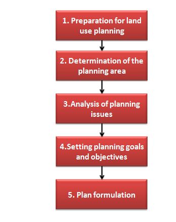
The development of a local land use plan usually follows a sequence of steps as indicated below.
Step 1: Preparation for land use planning
This step of the local land use planning process includes the definition of the purpose of the land use planning, the methodology to be applied, and the means of implementation of the plan. Based on a needs and problem analysis, clear objectives of land use planning process are to be defined. These objectives should reflect people's perceptions and priorities as well as overarching (regional, national or global) goals. Actors and stakeholders to be included in the planning process are identified, and relevant legislative and policy frameworks are reviewed.
For properly considering risks resulting from natural hazards it is important that in this step already adequate objectives of the planning with respect to hazard risks are defined, for example "all areas showing a high level of risk form natural hazards shall be kept free from any or further development: or "water retention areas need to be protected in order to mitigate risk from flooding".
Moreover, a group of GIS experts capable of processing risk related geo-data should be included in the plan development team, and legal and policy frameworks, documents, and acts that provide relevant information on hazards risk, is to be reviewed.
Step 2: Determination of the planning area and data collection
In this step the base line conditions in the plan area are described, including demarcation of the planning area, its general physical conditions, the demographic and socio-economic profile, and upcoming infrastructure projects. From a hazard risk point of view this step is important to understand the socio-spatial context of the area in which natural disasters might occur. This includes e.g. the topography and hydrological situation (drainage) as well as the socio-economic profile and distribution of the population, the latter being relevant for identifying groups or locations potentially vulnerable to natural hazards.
Moreover, suitable spatial and statistical data and information relevant for the planning process is to be collected and prepared (see table above for minimal data requirements). Next to information on physical conditions relevant for mapping risk form natural hazards, such as topography, soil conditions, slope, etc., also existing hazard data and information is to be collected, e.g. an already existing flood risk or land slide susceptibility map. Finally, the suitability of the data and information collected needs to be assessed. Besides the actuality of the data, the most important criteria for spatial information is their spatial resolution. As a rule of thumb, the data needs to be fine-scaled enough in order to determine and to distinguish situations on the local level, i.e. if not on parcel, but then at least on neighborhood level.
Step 3: planning issues and data analysis
In this step relevant planning issues and issues of environmental protection and hazard and risk mitigation are analyzed. This includes an analysis of the suitability of the land for future development in the main land use categories, i.e. residential, industrial, commercial, recreational, as well as a demarcation or protected and restricted areas that shall be kept free from further development. A suitability analysis defines how suitable the available land is for future use as e.g. residential or industrial land, based on a set of spatial suitability criteria, e.g. accessibility, slope, land values, or risk level. The counterpart of the suitability analysis is an analysis and mapping of protected and restricted areas that shall be kept free from development, such as areas having a high level of biodiversity or other ecological or cultural values and areas being at risk from hazards. In this analysis also existing settings form other plans, e.g. environmental protection areas, need to be taken into account. Methodologically, again, the method of suitability may be applied, but now for mapping vulnerable, or sensitive areas.
Step 4: Planning goal and objectives
In this step, the main goal of the planning and the subsequent planning objectives based on the analysis conducted above are to be defined. This means that the general goals as defined above in step 1 are here now concretized and fixed in spatial terms, indicating which areas are to be developed into what and which areas are to be kept free from development in order to achieve the above (step 1) defined broad goals. This requires a trade-off between the different issues and a normative judgments about what to do where and when within the plan area.
Step 5: Plan formulation
This step is closely linked to step 4, sometimes even done in conjunction. This steps translates the objectives set above into a spatial plan. It includes detailed description of future development activities for the different land use categories in conjunction with a development limitations analysis, the latter resulting in a development limitations map. This map integrates all areas restricted for development because of risks form natural hazards, as analyzed above.
Example application for the area of Greater Grenville
Step 1: Preparation for land use planning
The purpose of the Greater Grenville local area plan is to provide a framework for the subsequent development of any area within the Greater Grenville Region. In the Greater Grenville local land use planning case main goals are:
- To enhance protection of the environment, including storm water management and drainage, hazard mitigation (landslides and flooding), water and sewer services, and coastal erosion.
- To enhance transportation, including vehicular flow, pedestrian access and safety, and public transport
- To preserve and strengthen agriculture as an important economic activity
- To revitalize waterfronts and beachfronts, and protect the northern coastline
- To preserve historical and cultural assets
- To diversify Greater Grenville economic base.
- To develop a growth management strategy and establish a basic level of zoning, to help resolve land conflicts.
Except for the National Environment Policy and Management Strategy, that postulates to prevent negative impacts of environmental change and natural disasters, no explicit objectives with respect to hazard mitigation through spatial development are mentioned in any national or regional planning frameworks.
Step 2: Determination of the planning area
The town of Grenville (about 1,200 inhabitants (2007)) is the second largest town in Grenada, located on the east coast within the Saint Andrew parish (about 27,100 inhabitants (2007). The project area for the Greater Grenville local area plan comprises Grenville town and for surrounding regions having a total population of 11,500 inhabitants in the case study area (see Figure 1 below).
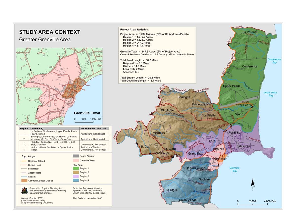
Figure 1: planning area
The topography of the Greater Grenville area (Figure 2) is one of the main limiting factors for development because of its mountainous characteristics.
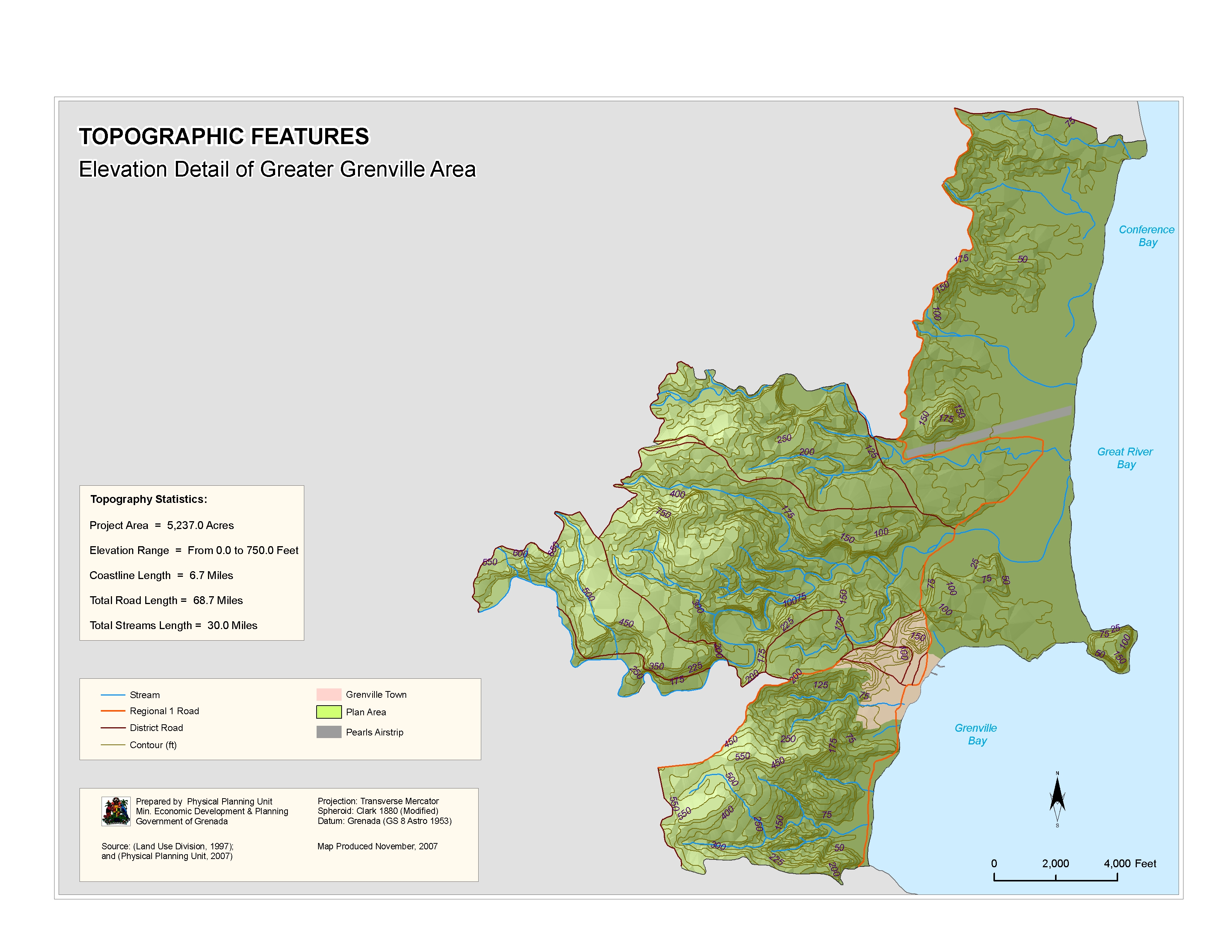
Figure 2: Topography
The current land use in the planning area (Figure 3) reveals a largely missing zoning system, resulting in a spread mixed land sue, mainly based on private development.
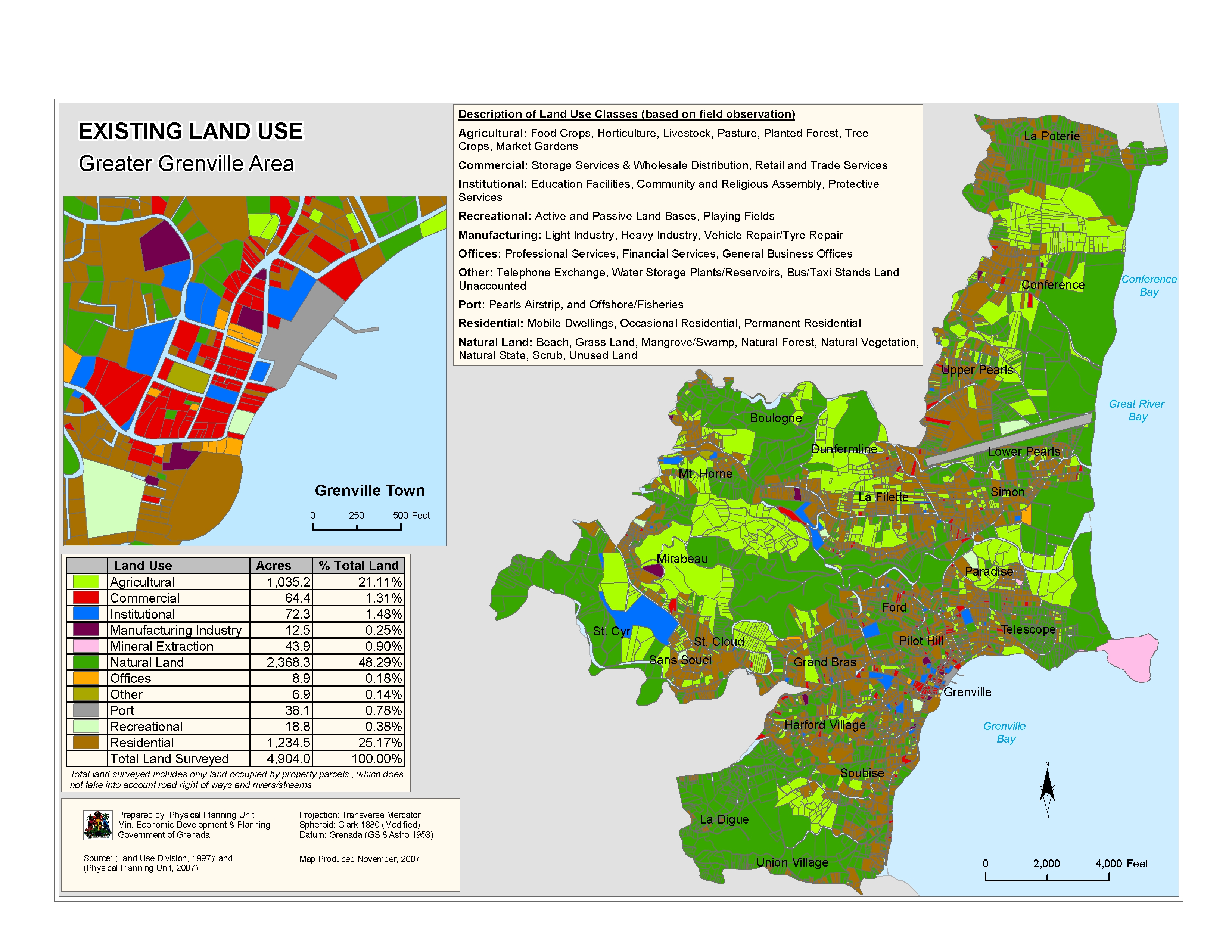
Figure 3: Current land use
The current distribution of the population (Figure 4) shows a very scattered development, along main transport networks.
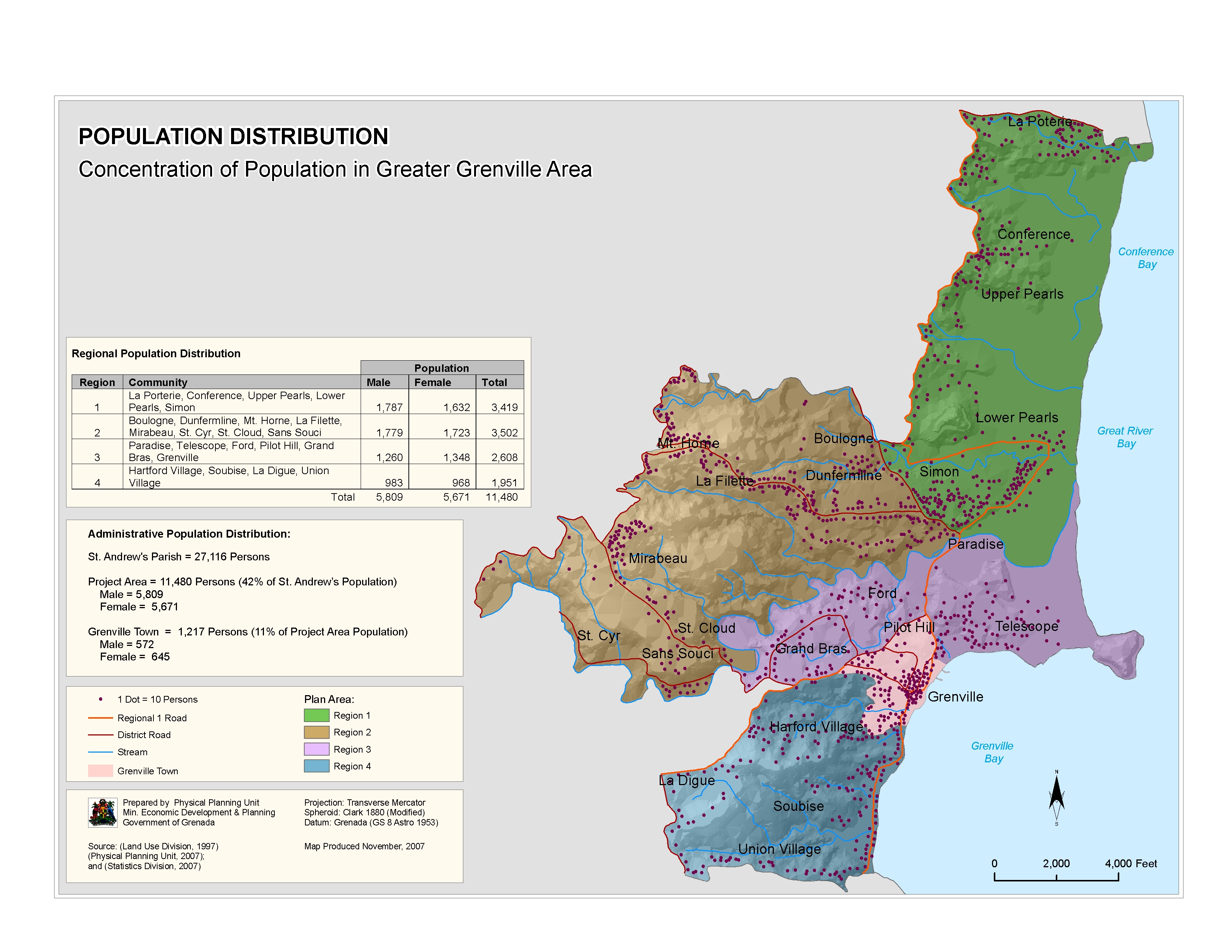
Figure 4: population distribution
Step 3: Planning issues and data analysis
Regarding hazard and risk mitigation the issues of inland flooding, coastal erosion and land slide susceptibility are the most important ones to be addressed in the Greater Grenville case. The main issues related to hazard mitigation and suggested remedial approaches for the Greater Grenville local area plan are:
- Protection against erosion (Figure 5): Certain coastal regions in the plan area have experienced erosion, measured in ft. based on observations (see Figure 5). In some locations the erosion width is more than 70 meters. These are the sites of significant sand mining. Enforcement against illegal sand mining must be in place to avoid coastal erosion. Additional measures include restoring mangroves for soil stability. In other erosion prone areas commercial development along the water should adhere to increased setbacks and have suitable foundation to raise structures to an acceptable level of protection from storm surge.
- Protection against landslides (Figure 6): Parts of the plan area are susceptible to landslides. The landslide susceptibility map was derived from a methodology that investigates the frequency of landslides with regard to soil type, geology, slope aspect, elevation, vegetation and rainfall intensity (see more details on the methodology in Figure 6 and in the methods book). In medium to high landslide hazard areas no further development should be allowed. Restrictions on any further development in these areas would limit any potential loss.
- Protection against inland flooding (Figure 7): Parts of the plan area are susceptible to flooding. The flood hazard map was derived from a medium-scale analysis that investigates the frequency of inland flooding with regard to land cover and soil hydrologic characteristics of the upper catchments, extreme daily rainfall, and the gradient of the catchment basin (see more details on the methodology in Figure 7 and in the methods book). Moreover, the projected storm surge data for 2020 levels indicates Grenville town and other areas in the plan area are subject to storm surge flooding. Development restrictions on areas identified as medium to high risk of flooding would limit any potential damage on these lands. Environmental initiatives, public awareness and education of local people and constant monitoring of these areas would ultimately reduce property damages.
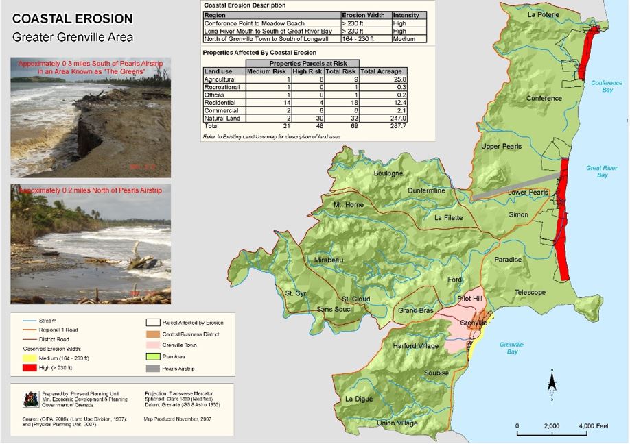
Figure 5: costal erosion in the case study area
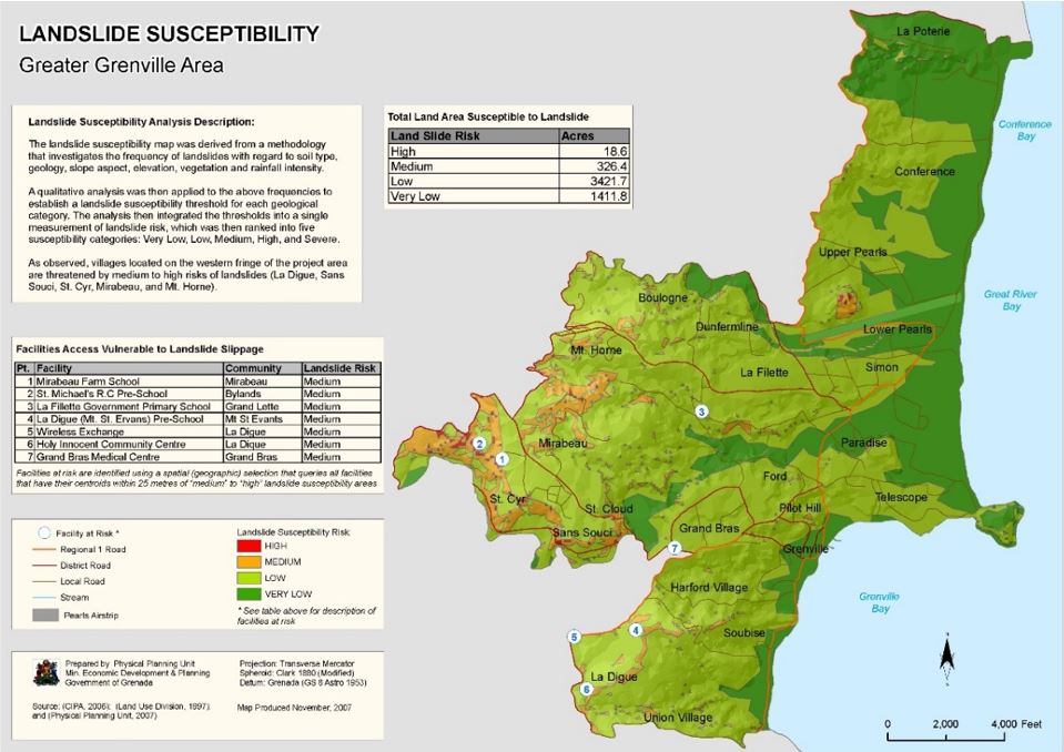
Figure 6: Landslide susceptibility in the case study area
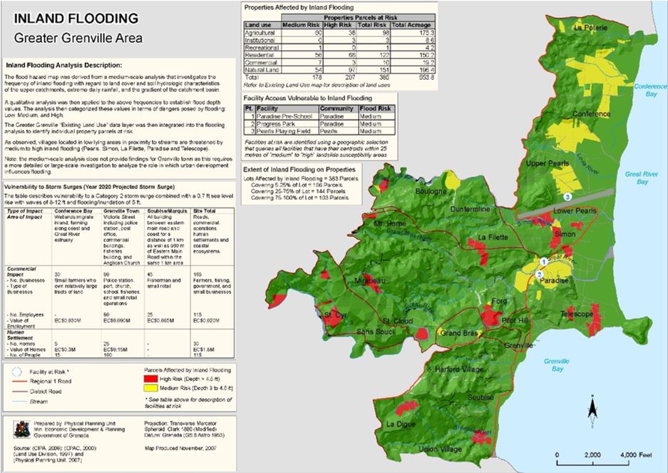
Figure 7: Inland flooding in the case study area
From these single hazard risk maps a multi-hazard risk map might be developed, that indicates all areas prone to risk from multiple hazards. A potential methodology of how to combine results of single hazards mapping into a multi-hazard risk map is given in Figure 8. The resulting multi-hazard risk map is shown in Figure 9.
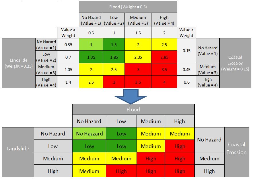
Figure 8: methodology for producing a multi hazard risk map
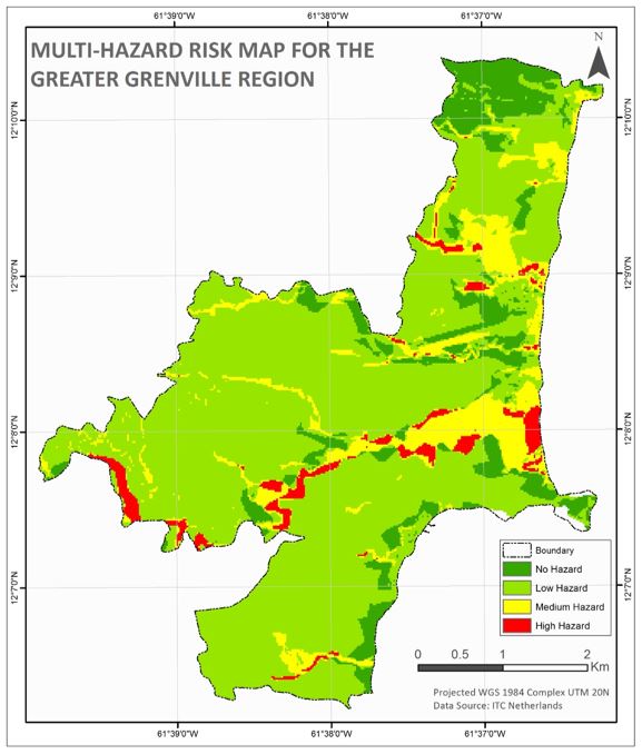
Figure 9: multi hazard risk map
A potential methodology for developing a suitability map for certain land sue categories (e.g. residential, industrial) based on multi criteria evaluation techniques is given in Figure 10. The resulting suitability map for further residential development and restructuring is given in Figure 11.
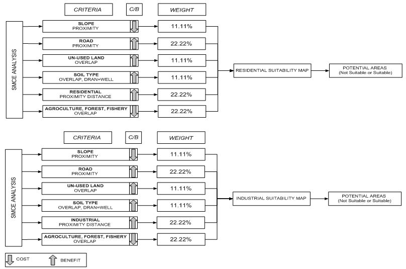
Figure 10: methodology for suitability analysis
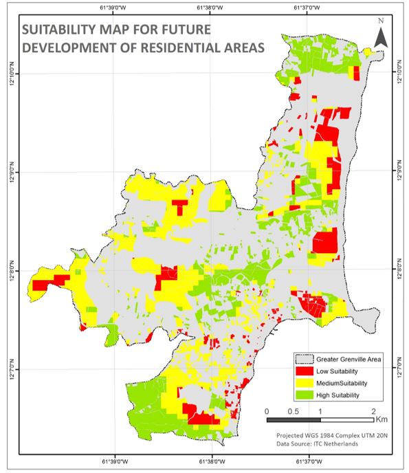
Figure 11: Residential suitability map
Step 4: Planning goal and objectives
In the case of the Greater Grenville local area plan a planning framework was developed that matches goals and objectives with lead actions and timeframes.
Goal 1, to enhance the protection of the environment contains with respect to hazard and risk mitigation the following objectives (out of a total of 6 objectives):
(1.2) hazard mitigation (landslides, flooding), divided into the action steps
(1.2.1) identify agricultural practice that prevent erosion, and
(1.2.2) prohibit development on hazard prone land through restrictive zoning.
(1.4) coastal erosion, comprising actions steps
(1.4.1) enforce law that prohibits sand mining,
(1.4.2) promote sustainable mangrove management,
(1.4.3) ensure a system of reefs is maintained to provide coastal protection.
For all action steps responsible lead agencies and starting dates are defined.
Step 5: Plan formulation
This step translates the objectives set above into a spatial plan and vision. It includes detailed description of future development activities for the different land use categories in conjunction with a development limitations analysis, the latter resulting in a development limitations map (Figure 12). This map integrates all areas restricted for development because of risks form natural hazards, as analyzed above. For the content of the development limitations map as well as the other hazard risk related future development activities see below the results section.
Results:
Results of the local area planning process include both, an integrated development limitation map and a set of concrete development activities (land use vision). Both results contain important element of hazard and risk mitigation.
The Development limitation map (Figure 12) is classified into 5 zones: Natural lands, Forest, Conservation area, Arable land, and Natural hazard risk. The natural lands category includes unused and marginal vegetated land. Development activities are only allowed close to the town area. The forested land use is not allowed for development except those activities which promote resource management and soil conservation. The conservation areas are heritage sites and protected seascape land. No development is recommended here except restoration and conservation of these resources. Arable land is the primary agriculture areas. The land is dedicated for agriculture purposes and no sub-division is permitted for any other development work. Finally, the natural hazard risk areas are identified as possessing medium to high susceptible to landslides, inland flooding, and coastal erosion. No further subdivision of these lands is encouraged, however mitigation measures against these threats are recommended.
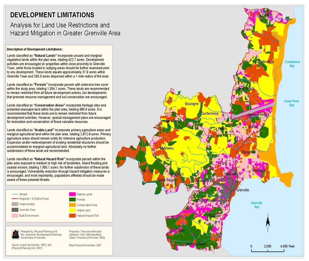
Figure 12: development limitations in the case study area
Further concrete spatial development activities with respect to natural hazards are the following:
- The community should be informed as to where "Natural Hazard Risks" are located in the Greater Grenville Area
- Suitable areas around Grenville Town exist for the creation of holding ponds for drainage outflows
- Lands classified as having a "Natural Hazard Risk" should be restricted from further subdivision and studied for potential hazard mitigation measures
- Sites vulnerable to coastal erosion (Figure 2), landslide slippage (Figure 3) and inland flooding (Figure 4) should undergo mitigation and remediation measures to address these concerns.
Zoning: Establishment of system of zoning. A zoning permit will be required to ensure compliance with the land uses and standards contained within individual zones. However, this concept is recommended as long term goal due to challenges related to regulations and land tenure ownership.
Conclusions:
A local land use planning is an integrative planning process making use of various types of information and analyses from various domains to determine the future use and development of land and resources in the case study area. The Greater Grenville local area development plan gives a good example for integrating hazard and risk information into local land use planning. Based on available spatial data of physical and socioeconomic conditions in the case study area various maps of risks resulting from natural hazards are produced, integrated into an overall development limitation map and matched with a list of concrete development activities to form a land use vision.
The quality of a local land use plan depends much on the quality of the input in terms of different layers of information as well various analyses, such as hazards and risk maps being produced. the here presented example of the Greater Grenville local area plan does not yet include any information on hazards impacts and vulnerabilities, which could be added and used in the planning process, if relevant information would be available.
Last update: 15-07-2016