

The simplest way to reduce the consequences of a hazard is to avoid developing in hazard prone areas. However this is not always possible, so risk reduction and mitigation measures may be required to lessen the severity of a disaster due to landslide hazard.
This use-case focuses on the process of identification and evaluation of cost-effective structural and non-structural landslide mitigation options that can be implemented during the planning and design of the building, or for retrofitting if the building has already been constructed. It also lists the site related structural, and non-structural measures that can be applied to protect building surroundings to reduce the landslide hazard consequences.
The purpose of this analysis is to assist decision-making and to guide the user in the choice of the most appropriate mitigation measures. It provides the ranking of the mitigation measures for potential landslides situations through simple weighted scoring factors for each evaluation criteria, and decision support matrix. The Mitigation measure are based on technology, experience, recommended practice and expert judgment and mitigation measures with the highest ranking can be considered as most appropriate. While weighing the potential measures for implementation it should be considered that how climate change and other global phenomena can affect the efficacy and reliability of the mitigation measures.
The Caribbean Islands are characterized by their intense heavy rainfall and steep slopes which give to frequent landslide occurrence. The steep slopes prevalent in these islands together with the materials underlying the slopes provide a favourable condition for landslide creation. Because these slopes are close to failure, their stability is likely to be affected by a small triggering effect and cause landslide. The main triggering factor is the rainfall. Most of the landslides are related to these human activities like road construction which disturb the natural slope characteristics and increase their probability of failure. Various types of landslides and possible structural measures are discussed to guide the user in the choice of the most appropriate mitigation measures and are also illustrated with examples.
Keywords:
Landslide hazard, structural measures, landslide protection
| Before you start: | Use case Location: | Uses GIS data: | Authors: |
|---|---|---|---|
|
Section 3.2 of use case book for categorization of critical infrastructures and section 8.4 of methodology handbook for structural mitigation measures for landslides should be read before this use case |
Most of the countries in the Caribbean region, because of the hilly terrain, torrential rains, and areas of possible landslide hazard. |
No | Naveed Anwar |
Introduction:
Landslides risk mitigation strategies can generally be categorized as: Structural Mitigation measures and Non-Structural Mitigation measures
- Structural measures could be the measures to strengthen the building/construction itself or any physical construction to reduce the landslide hazard and avoid possible impacts of hazard around the building site. These structural measures include, but are not limited to drainage, erosion protection, channeling, vegetation, ground improvement, barriers such as earth ramparts, walls, artificial elevated land, anchoring systems and retaining structures; buildings designed and/or placed in locations to withstand the impact forces of landslides and to provide safe dwellings for people, and escape routes
- Non-structural measures such as land-use planning and early warning systems, are used to reduce the hazard consequences, and transfer the risks.
Mitigation measures listed in this use case are classified as: measures to reduce the hazard, and measures to reduce the consequences by increasing the resistance of elements at risk. Many classifications for mitigation measures have been proposed based on the similar concepts but expressed in different terms.
The main terms used in this analysis are defined as:
- Hazard (H): Damaging Phenomenon occurring in the specific area, means the probability of occurrence within a specified period of time and within a given area.
- Vulnerability (V): means the degree of loss to a given element or set of elements at risk resulting from the occurrence of a specific phenomenon of a given magnitude impinging on the area.
- Elements at risk (E): means the population, buildings, engineering works, economic activities, public services utilities, other infrastructure and environmental values in a given area.
- Total Risk (R): Risk=Hazard*Vulnerability*Elements at risk
Further description about classification of mitigation measures is provided in the methodology book section 8.4 "Design of structural mitigation measures to protect critical infrastructure in dangerous locations".
|
Type of Movement |
Type of Material |
|||
|---|---|---|---|---|
|
Bed Rock |
Engineering Soils |
|||
|
Predominantly Coarse |
Predominantly Fine |
|||
|
Falls |
Rock Fall |
Debris Fall |
Earth Fall |
|
|
Topples |
Rock Topple |
Debris Topple |
Earth Topple |
|
|
Slides |
Rational |
Rock Slide |
Debris Slide |
Earth Slide |
|
Transitional |
||||
|
Lateral Spreads |
Rock Spread |
Debris Spread |
Earth Spread |
|
|
Flows |
Rock Flows (deep creep) |
Debris Flows (soil creep) |
Earth Flows (soil creep) |
|
|
Complex |
Combination of two or more principals types of movements |
|||
Table 1: Types of Landslides-Abbreviated version of Varnes' classification of slope movements (Varnes, 1978)
Objectives:
This use case focuses on the process to evaluate the mitigation measures that can be applied for protection of critical infrastructure buildings against landslide. These could be a measure to carry out in the direct surrounding of the buildings (drainage, retaining walls, retention basins, debris flow protection works), or incorporate strength, stiffness and ductility into the structural system. It also describe the process of analyzing methods that may apply to different scenarios and illustrates with the examples of good practices. This use case as outlined in the topic considers the buildings that are already located in the dangerous locations.
Flowchart:
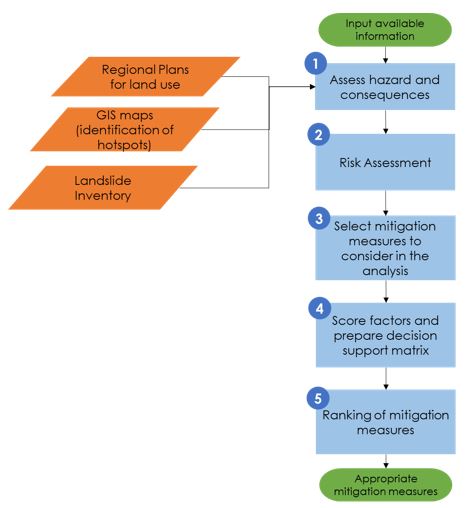
Figure 1: Overall procedure for selection of appropriate mitigation measures for landslide hazard for critical infrastructures (buildings).
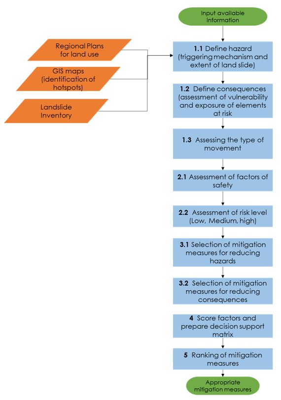
Figure 2: Detailed Process for analysis and selection of mitigation measures for land slide hazard
Problems definition and specifications:
The main cause of damage in Caribbean Islands due to landslides can be attributed to building being built on unstable slopes, soil and rock susceptible to falls, soil and rock susceptible to topples, soil and rock susceptible to spreads, soil and rock susceptible to flows, precipitation that triggers slope failure, and ground shaking that triggers slope failure.
Therefore, it is critical to have a procedure to evaluate and select appropriate cost-effective mitigation measures for critical infrastructure to protect from landslide hazard. This use case discusses the procedures and consideration for protecting buildings that are to critical infrastructures and facilities from the consequences of landslide hazard and risk.
Data requirements:
Following data may be required:
- Landslide Inventory maps
- Risk maps
- Land use plans
- Building plans, and structural design information
- GIS based landslide susceptibility analysis(spatial probability)
Analysis steps:
General Application
The process of analysis starts with all available information related to building.
1. Assess Hazard and Consequences
1.1 Define Hazard: The first step in the analysis is to define the hazard by collecting information related to triggering mechanism and extent of landslide for example volume (M3), Run-out distance (m), and Slope angle. This information can be obtained from land slide inventory maps. GIS maps and past data.
The risk maps at a larger scale, such as greater than 1:500 can be used for the overall planning and locating the buildings, where smaller scale site maps and investigations will be needed for planning of the mitigation measures for individual buildings
1.2 Define Consequences: The evaluation of consequences depends on the vulnerability and the exposure. In the consequences of instability, elements at risk can be human life, critical infrastructure buildings for example school, and hospital. (Link to UC 3.2.1 "Buildings for classification of Critical Infrastructure").
1.3 Assessing the type of movement: This step involves the defining the types of slope such as, Rock slide, Landslide, or Debris flow and the type of movement that is expected such as; fall, topple, slide, spread, and flow.
2. Risk Assessment
2.1 Slope characteristics and assessment of factors of safety: It is required to consider the soil or rock type, available soil properties, probability of movement observed in the previous years, and uncertainty in soil parameter.
2.2 Assessment of risk level (Low, Medium, High): Risk level is estimated based on hazard and consequences level. It depends on the level and detail of information available as well as the engineer's expertise.
Three main risk classes can be assigned to the analysis case based on a combination of levels of consequence and hazard selected by the engineer.
|
Risk Level |
Definition |
|---|---|
|
High |
An unacceptable risk that requires new site investigations, stability calculations and mitigation measures |
|
Medium |
Risk may be acceptable but redesign and other changes should be considered if practical. It requires considering conducting new site investigations and analyses. Risk can be reduced by reducing the hazard and/or reducing the consequences |
|
Low |
Keep monitoring the slope, further risk reducing measures are not necessary |
Table 2: Risk level (low, medium, high) and definition
3. Selection of mitigation measures for analysis
3.1 Selection of mitigation measures for reducing hazards: Various basic structural mitigation measures based on the type of landslide hazard and its effects are described in Table 3. These can be used as the initial check-list or as the basis for eliminating measures that may not be relevant. A more comprehensive list of measures is given in the Methodology Book, Chapter 8.4.
3.2 Selection of mitigation measures for reducing consequences:
The following non-structural mitigation measures, reducing the consequences are:
- Early warning systems
- Restrict or discourage construction activities
- Increasing resistance through shelter, evacuation strategies etc.
- Relocation or not using the building for critical services
These non-structural mitigation measures will not have quantitative scoring.
4. Scoring of factors and preparation of decision support matrix
The decision support matrix can be prepared based on the scoring of factors (Fi) for each mitigation measure the user has to consider, adopt or modify during his/her assessment of the problem at hand. The scoring for all ranking parameters is on a scale of 1 to 10, where 1 describes the least favorable attribute (worst, lowest, poorest, most expensive), and 10 the most favorable attribute (best, highest, strongest, least expensive or not expensive). The scoring of 0 is used when the mitigation measure is inapplicable or inappropriate. A more formal decision making method, such as Analytical Hierarchy Process (AHP) may also be used based on similar scoring system.
| Ranking Criteria | Descriptor |
|---|---|
| Depth of Movement |
|
| Rate of movement |
|
| Groundwater |
|
| Surface water |
|
Table 3: Ranking Criteria other than type of movement and material types
5. Ranking of mitigation measures
The selection of the most appropriate mitigation measures to be adopted in specific situations take into account the following:
- Factors that affect the hazard, in terms of the type, rate, depth and the probability of occurrence of the movement or landslide
- Factors that affect the nature and the quantification of risk for a given hazard, such as the presence and vulnerability of elements at risk, both in the potentially unstable area and in the run-out area
- Factors that affect the feasibility of specific mitigation measures, such as, for example: the phase and rate of movement at the time of implementation.
Factors are further explained in Methodology Book Section 8.4.
To rank the selected mitigation measures, a simple additive formula with weighted scoring factors can be used. The ranking (Ri) is therefore done on the basis of the summation of weighted (wi) contributing factors (Fi) for each evaluation criterion:
Where i = mitigation measures selected by the user for analysis, 1, 2, "¦, n
w = weighted factor the default value for all wi at start is 1,0
F = scoring factor.
The user can input the values of F and w according to his/her experience and/or engineering judgment. Weighting factor (wi) reflecting the relative importance of criteria or corresponding scoring factors is in the range of 0 (least) to 1 (most).
This process will give the relative ranking score for the all the selected mitigation measures for the analysis in the specific situation. The mitigation measure with highest ranking will be the most appropriate for the particular situation.
Preference may also be given to the bio-engineering, non-structural solution using appropriate plantation, greening, forestation, etc. to improve the stability of soil masses, and to the technologies that are based on conventional local practices, for which local labor and skills are available, such stone gabion walls, etc.
| Ranking Criteria | Descriptor |
|---|---|
| Maturity of technology |
|
| Reliability in terms of uncertainty in design |
|
| Reliability in terms of uncertainty in implementation |
|
| Safety during construction |
|
| Typical cost |
|
Table 4: Ranking criteria for mitigation measures
[1] Safe Land Project, 7th Framework
Example Applications
Mitigation Measures: Retaining Walls
Source: "Alpine Way, New South Wales, Australia"
Reference: "ABCB Land Slide Hazards, 2006 Handbook (Non Regulatory Document)"
Figure 3 illustrates the extent of damage following a landslide in the mountainous Thredbo area. A damaged water main caused a two stage landslide of fill that supported the Alpine Way road. The reconstruction of the Alpine Way as seen in Figure 4 involved major engineering works including the installation of reinforced gabion retaining walls.
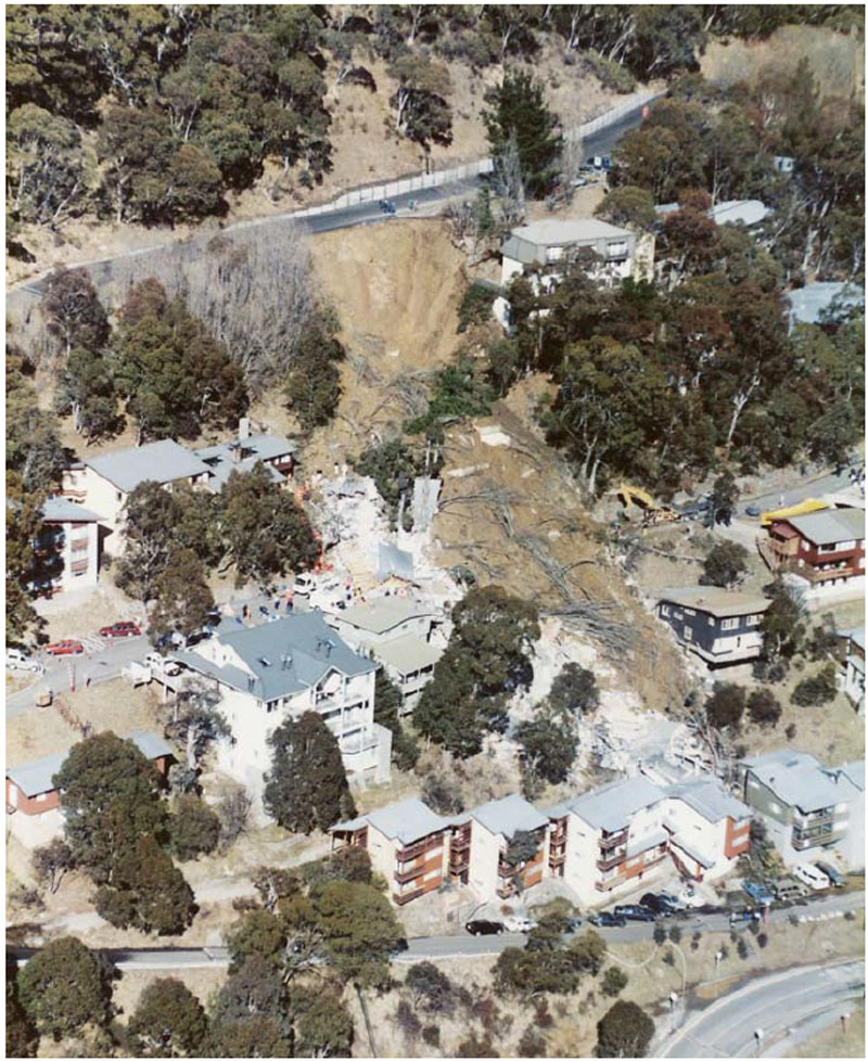
Figure 3: Thredbo Landslide (30 July, 1997)
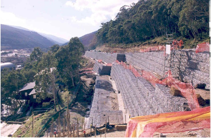
Figure 4:Reconstruction of Alpine Way Thredbo
Mitigation Measure: Fill Slopes and Soil Nailing
Source: "Landslide disaster prevention and mitigation through works in Hong Kong"
By K.Y Choi and Raymond W.M Cheung (Journal of Rock Mechanics and Geotechnical Engineering)
It involves the installation of soil nails through the fill materials with the provision of a surface grillage connecting the soil nails head. The existing trees can be preserved during the construction process. The soil nails are embedded in competent subsurface stratum to ensure sufficient anchorage against pull-out. Because of the construction advantages offered through the use of soil nailing, the method is now commonly used for upgrading fill slopes.
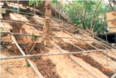
Figure 5: Construction of Soil Nails and Grillage
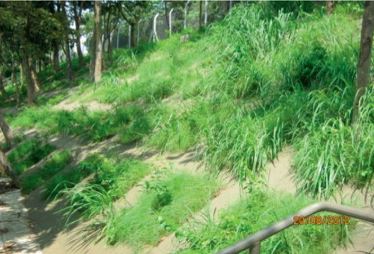
Figure 6: Completion of Soil Nails and Grillage
Mitigation Measure: Deep Shafts (Dowels)
Source: "Deep shafts (dowels) as an effective structural mitigation measure on large landslides in Slovenia"
B. Pulko (1), M. Mikos (1), R. Fazarinc (2), A. Petkovsek (1), B. Majes (1) (1) University of Ljubljana, Faculty of Civil and Geodetic Engineering, Ljubljana, Slovenia, (2) Water Engineering Ltd., Ljubljana, Slovenia (
Large and deep-seated landslides ask for heavy constructions that stabilize such unstable slopes. Usually, this kind of structures cannot be built in fast moving landslide masses. One option is to build them during dormant phases of a landslide (dry periods without rain or cold winter time). The other is to slow down the landslide movement to be able to build large supporting structures, such as supporting walls or similar concrete structures. In order to slow down a fast moving landslide (> 10 cm/day) it is often necessary first to drain surficial waters by a drainage system and then to lower groundwater level.
Mitigation Measure: Ground Anchor Wall
Source: "RICHARDSON HIGHWAY MP 296 Land Slide Mitigation, Richardson, Alaska"
Reference: http://www.landslidetechnology.com/rockfall.htm
The Richardson Highway project is located on Alaska Highway 2 at Mile point 296.3, which is about 60 miles east of Fairbanks along a stretch of steep side-hill cut/fill above the Tanana River. A landslide affected approximately 140 feet of the highway. Significant movement in the pavement was first identified in 1996. During the summers of 1999 and 2000, the rate of landslide movement accelerated over previous years. Maintenance was required to grade the roadway to keep it safe for travel.
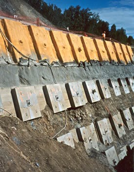
Figure 7: Ground Anchor Wall during Construction
Mitigation Measure: Horizontal Drain to Dewater the Land Slide
Source: "HILLIS HILL LANDSLIDE, Clark County, Washington"
Reference: http://www.landslidetechnology.com/rockfall.htm
The Hillis Hill Landslide area is located on a west-facing slope above the Lewis River, approximately 1 mile south of Woodland on the Pacific Highway (Clark County Road 1). The slide area is a locally active portion of a much larger ancient landslide that extends approximately 1,200 feet along the highway, and 2,000 feet upslope from the Lewis River. Landslide Technology (LT) assisted Clark County with the stabilization of two active segments of the slide, which were termed the "Hillis Hill" and "Hillis Hill No. 2" Slides. The investigation and repair of the original Hillis Hill Slide occurred between 1997 and 2001. Following phases of investigation, monitoring, and design, the original slide was mitigated with a horizontal drain system installed in October 2001, and has remained stable since then.
The Hillis Hill No. 2 Slide occurred on January 18, 2006 during an intense winter rainstorm. The slide was located below the outboard (southbound) lane of the highway, and was moving downhill toward the floodplain of the Lewis River. The slide heads carp had extended to the edge of pavement, and the shoulder of the road embankment had dropped 5 to 7 feet. As a precaution, the Clark County Department of Public Works closed the southbound lane and restricted the road to one-way traffic through the slide area.
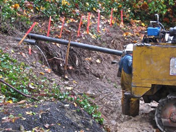
Figure 8: Horizontal Drain to Dewater the Landslide
Conclusions:
In the Caribbean islands, the risk of landslide hazard is high, especially because of the topography, and the fact that many communities are either located on the slopes or in the planes next to the hill slopes, where landslide can be triggered either due to floods, hurricanes, geological process or earthquakes.
Land-slide hazard is one of the more difficult one to address, as this may involve extensive risk analysis and geotechnical investigations, in addition to risk maps, which may not be readily available in most areas. The land slide risk mitigation measures may often extend beyond the building area, and property lines, difficult to include within the scope of the building project.
Appropriate structural mitigation measures, both around the building site to prevent the slides from happening, and within the building property lines that protect the buildings from land slide can be selected and evaluated through the process of decision support matrix and ranking of mitigation measures.
For critical infrastructure, the non-structural mitigation measures for reducing consequences such as warning system, evacuation plans, and restriction of construction should be given importance along with structural mitigation measures to reduce the impact on operational activity during hazard.
References:
Seventh Framework Programme "SAFE LAND", Safe Australian Building Codes-Handbook-Non Regulatory Document-Landslide 2006 Land Living with landslide risk in Europe: Assessment, effects of global change, and risk management strategies 7th Framework Programme Cooperation Theme 6 Environment (including climate change) Sub-Activity 6.1.3 Natural Hazards, Deliverable 5.2
Australian Building Codes-Handbook Non-regulatory Document-Landslide 2006
Last update: 24-04-2016