

Before You Start:
Authors:
Dr. Manzul Kumar Hazarika and Mr. Ramesh De Silva
Keywords:
Geospatial data, NSDI
Introduction
When it comes to sharing geospatial information, it is a challenge because the world geography is diverse, dynamic and complex. What the geospatial data is designed to capture is influenced by our professional discipline, our culture, and/or our view of the world in light of the subject we are addressing at a particular time. The purpose of a National Spatial Data Infrastructure (NSDI) is to facilitate and coordinate the useful exchange and sharing of geographic information and services. It is the means by which governments and organizations have developed interoperability for geographic information. The data produced according to the guidelines of the NSDI:
- are ready and available to be used in a geographic information system;
- can be easily distributed for others to use;
- can be worked on by two or more people or organizations at once;
- can be applied in many different ways;
- are much more efficient and cost effective to use.
In order to get the maximum benefit from NSDI, it is necessary to have a well-organized and carefully coordinated framework and policies in place for data and infrastructure management, coordination among the stakeholders and an enabling environment. Unless there is a proper understanding and coordination among the stakeholders, a sustainable geo-spatial data sharing system cannot be developed.
Objectives
Provide an overview of NSDI for institutional collaboration.
Description
National Spatial Data Infrastructure (NSDI) is the key component for the geo-spatial framework for institutional collaboration. The NSDI has to manage the following aspects in order to provide a proper mechanism to facilitate collaboration among the institutes and sustain the geospatial data sharing platform: 1) stakeholders from organizations and agencies and coordination among them, 2) a supportive environment for the sharing and utilization of geospatial data, 3) technology and infrastructure, and 4) human resources involving academic, experts and entities. The diagram below (Figure 1) gives a better understanding of the framework.
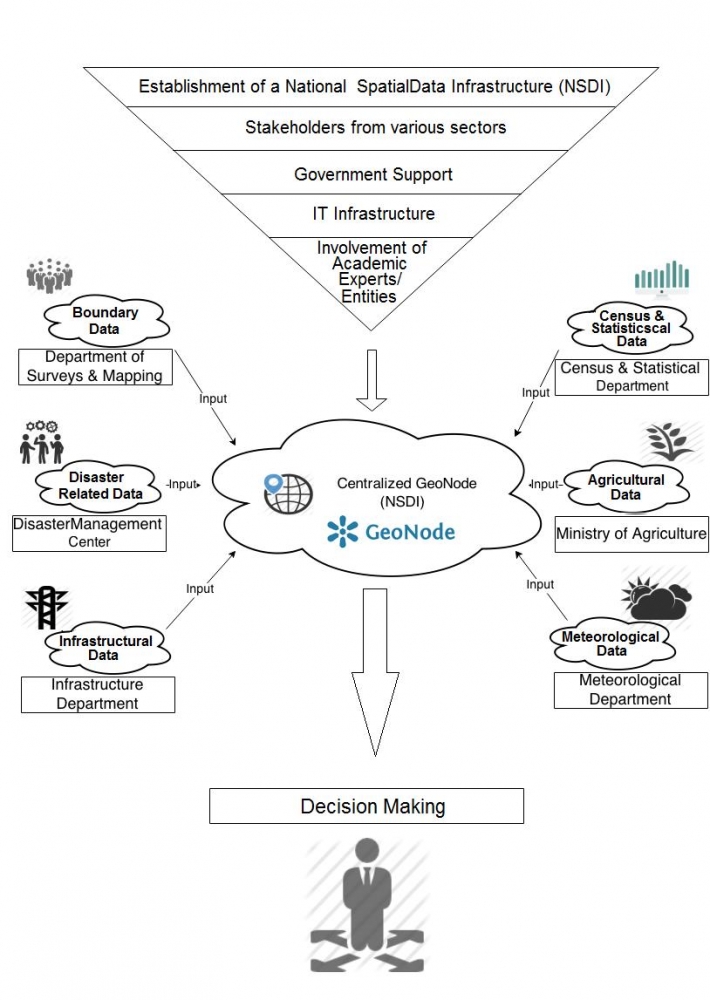
Figure 1: An example of a framework of a country level data sharing
1) Stakeholders
The reality of data is that they are often scattered in different agencies within a country. NSDI can be used to aid in the collection, processing, management, access, delivery, and use of geospatial data from a wide range of agencies. The process of establishing a NSDI varies from country to country. The involvement of the policy makers of a country is certainly required to appoint an NSDI. For an example, the government of Belize has assigned the Ministry of Natural Resources and Agriculture as the focal Ministry leading the development of Belize's NSDI. By bringing various stakeholders under the NSDI, it is possible to bring data to one place. To achieve this, NSDI needs to encourage and setup institutional agreements on data sharing policies. It is the responsibility of NSDI to define the responsible departments for primary data, based on their respective domain. For example, NSDI may assign the responsibility of maintaining the up to date census data of the country to the Census Department of that country. In the proposed framework, it is possible for NSDI to facilitate access rights of each data set, based on the suggestions and recommendations of the owner of data. In case of census data, permission can be set to make the data available to public or to group of users based on the agreement between NSDI and Census Department.
2) Supportive environment
For NSDI to succeed, it is essential to receive continuous support from the governments. In order to form the NSDI, a government of a country need to examine the agencies in the country that are actively developing spatial data. Further they should identify a focal point for this purpose. For an example, the government of Belize has assigned the Ministry of Natural Resources and Agriculture as their focal point. Further, government needs to support and develop coordination among the agencies and create an enabling environment for data sharing. The ministry or agency establishing the NSDI in a country should promote awareness on the importance of NSDI to its national counterparts and seek their support as well as establish and promote policies and legal frameworks to enable the efficient sharing of geospatial data. A major challenge in inter-agency sharing is the perceived loss of authority and power of said data; however these challenges can be overcome through reassurance to the principle data holding agencies that the sharing of data benefits both the government and its citizens. Hence policies and agreements must be adopted by the governments to facilitate and encourage open data sharing, by emphasizing the necessity of geospatial data for humanitarian assistance, especially during disasters. Also it's important to ensure agencies that sensitive data, a dataset that may cause a threat to national security for example can be restricted based on NSDI data access rights.
3) Technologies and infrastructures
Technologies and its Standards are important for NSDI. A standard is a documented agreement between a producer and a consumer, i.e., a reference document to be used in contracts and international trade which specifies definitions of characteristics, technical design or content, precise criteria, rules, or guidelines. Standards ensure that material products, processes, and services are fit for purpose and some useful standards are described in Chapter 6.5 (Metadata Requirements) and Chapter 7.4 (Data Standards) in the Data Management Book.
Infrastructure is also critical for establishing the NSDI, which is normally a centralized system to host a large amount of data with many concurrent connections to the servers. Further, high network traffic is expected and, therefore, it is essential to have a reliable and persistent internet connection such as a leased line. The system should operate 24x7 and requires redundant power supplies, system backups etc.
4) Human Resources
NSDI will be successful only if the information is provided, accessed, and used by knowledgeable people and organizations. Users of information must have the necessary training and knowledge to understand and use it properly. Users must know, for example, which type of resources can be used for a specific analysis. Efficient and proper application of spatial data requires education and knowledge in information technology, databases, and in some cases web applications, geodesy and coordinate reference systems, remote sensing, statistics, and spatial theory. Involvement of academic institutes/universities and research institutes will help in creating a knowledge hub as they provide undergraduate degrees, multidisciplinary graduate education, and advanced research programs.
Present status of Geospatial Data sharing frameworks in participating countries
The following sections describe the existing geospatial data sharing frameworks in Belize, Dominica, Grenada, St. Lucia, and St. Vincent and the Grenadines.
Belize
Belize has shown lot of progress in terms of collecting and sharing nationwide geospatial data. Belize National Spatial Data Infrastructure (BNSDI) developed under The Ministry of Natural Resources and Immigration has taken the lead role in this regard. BNSDI is responsible for defining policies, procedures and standards for effective management of geospatial data. Importantly there is a high level of interest among the stakeholders as well as a good support from Government of Belize (GOB) for this initiative. Together with World Bank, GOB provides continuous support to NSDI in Belize, through the Belize Climate Resilient Infrastructure Project (BCRIP) including consultancy services to review NSDI progress for its further implementation.
BNSDI's roles:
- Motivate organizations to improve their data (quality, standards, storage, metadata etc.)
- Collaborate and share data among partners for mutual benefits and national development
- Facilitate training and networking opportunities
- Addressing national issues (crime, poverty, environmental degradation etc.)
- Assist in prioritization of resources (e.g. BCRIP roads infrastructure database)
Data Sharing Framework:
- Participating stakeholders organize and provide their data;
- Use the adopted standards (e.g. North American Profile of the ISO 19115 Metadata standards)
- There are about 40 geospatial data layers in the system
- All the data can be accessed via a GeoNode base system at: http://geoserver.bnsdi.gov.bz
Dominica
Dominica has an active GIS user group equipped with technologies such as mobile mapping and real time data capturing using smartphones etc. University students have been actively engaged in such data collection activities. GeoNode has been deployed and available online to facilitate the data sharing process.
- 50 data layers have been uploaded to the system
- All the data can be accessed via a GeoNode base system at: http://www.dominode.net/
Grenada
In Grenada, geospatial data are being used by various departments for planning and decision-making. Agricultural Department, Statistics Department, Physical Planning Unit etc. are using the geospatial data to improve the quality of service in their respective operations. Grenada has received a formal training on data management and a geospatial data sharing system has been established.
- The system has about 40 data layers
- The system is available for Intranet users only
However, currently Grenada is facing some issues as follows.
- Lack of sufficient IT infrastructures
- Lack of human resources
- Lack of sufficient data to share and outdated data layers
St. Lucia
Geospatial data are being used by both government and private organizations in St. Lucia. Several kinds of data such as boundary data, hydrological data, meteorological data, census data, disaster related data, archaeological data, infrastructure related data, and satellite imageries are available for the country. St. Lucia has received training on spatial data management.
- There are about 34 data layers uploaded to the system for sharing
- All the data can be accessed via a GeoNode base system at: http://sling.gosl.gov.lc/
St. Lucia is also focusing on improvements in various factors in order to streamline the spatial data sharing mechanism. Some of the issues currently being faced by St Lucia are as follows.
- Housing, ownership and maintenance of the system
- No formal data standards on metadata
- Lack of support from upper levels of Government
- Duplication of efforts by multiple agencies
- Data exists but not known to outside of an agency
- Slow server and IT network
St. Vincent and the Grenadines
St. Vincent and the Grenadines has established a GIS Unit, focusing to assist policy makers in decision-making process by providing access to reliable, timely data. They are working to develop a National GIS database to improve efficiency in both private and public sectors. They have a GeoNode based data sharing system, being managed by the Physical Planning Unit.
- They have about 50 data layers uploaded to the system
- All the data can be accessed via a GeoNode base system at: http://geonode.gov.vc/
However a few challengers have been reported as follows.
- Lack of GIS data policy
- Resistance to share Data
- Data acquisition is costly