Landslide inventory mapping
Author: Cees van Westen
Introduction
Landslide inventories are the basis for assessing landslide susceptibility, hazard and risk (Soeters and Van Westen, 1996; Aleotti and Chowdury, 1999; Ardizzone et al., 2002; Dai and Lee, 2008; Van Westen et al., 2008). They are essential for susceptibility models that predict landslide on the basis of past conditions. If these are not sufficiently available more emphasis should be given on expert assessment and evaluation. Therefore we need to know where landslides happened in the past. The conditions under which landslides happened in the past are analyzed and the relevant combinations are used to predict future ones. We need to understand the causal relations between landslides and the causal factors. These conditions differ for different landslide types, and therefore landslides should be classified into different types. Temporal information is essential to estimate the frequency of landslides. Therefore we need to know when they happened. Landslide inventories are also used to validate landslide susceptibility, hazard and risk maps.
Who is interested in landslide information, and what type of information?
Within the Windward Islands there are several organizations that should/could use landslide information to better perform the tasks assigned to them.
- The Public Works Departments: they require landslide information to better identify the most vulnerable sections of the road network, plan for road clearance after the occurrence of triggering events, to plan remedial measures for impacted road sectors, and for planning new roads, and alternative routes. They would require digital information on the road network in the form of a road database, which stores information for each segment of the road network. These segments should be based on the specific characteristics of the road and the terrain through which the road passes. The individual segments should contain information on the slope conditions on both sides of the road, the road drainage, road surface conditions, and on the landslides that have affected the road segment. The landslide information should consist of landslide susceptibility, hazard and risk classes of the road segments, quantitative landslide hazard and risk of specific problematic points, and landslide inventory information. Landslide inventory information should consists of: Date of occurrence, identifier of road segment affected, length indication of affected road, Type of landslide, type of damage, volume of landslide, and cost of clearance.
- Planning and Development Authority (PDA): they need landslide information to better include unsuitable areas for development in national and local level land use plans. They also need to include this information in the building permit issuing and in land subdivision process. They need landslide susceptibility maps for national scale planning, or landslide hazard maps for the larger scales. These should be integrated with other natural hazard maps in a multi-hazard restriction map that should have a legal status and serves as base data for planning. After a landslide event has taken place, they need to know the characteristics of the affected area, in order to develop reconstruction plans.
- Forestry Department: landslides may impact forests substantially, and for forest management it is important to take into account where landslides have occurred recently, and how vegetation regrowth takes place in areas affected by landslides. It is also very important to rapidly map landslides in forested areas after a major triggering event, as the debrisflows and flashfloods that may follow from these events can have a large impact on downstream areas. For this historical landslide inventories (where, when, what, how large landslides have been) including the source and accumulation areas are of importance. Also a landslide susceptibility map is important, and if possible landslide hazard scenarios, where the potential instable areas are modelled for specific rainfall amount with certain frequencies. From previous events, such as hurricane Tomas in Saint Lucia, we have also learned the importance to monitor the areas affected by landslides during a large triggering event, as they may slowly recover, but could be reactivated if a new event occurs (e.g. the Christmas eve trough in 2013).
- Water Resources department: for watershed management purposes it is very important to know the location of historical landslides, and to estimate the amount of sediments, and treetrunks that may be transported through the drainage channel in case of strong rainfall events. Similar data requirements as indicated for the forestry department can be outlined for the water resources department, although the interaction of landslides with the drainage network (e.g. in terms of sediment delivery but also in terms of potential blocking sites) is of large importance.
- The National Emergency Management Organisation (NEMO) / Office of Disaster Management (ODM): It is very important for the disaster response organisations to learn from past events, in order to better prepare for future ones. A good knowledge on the location of landslides, and the characteristics related to blockage of roads, destruction of buildings, electricity networks, telecommunication facilities, and the number and type of casualties is very important. Specific emphasis should be given to landslide hazard assessment of the shelters, and other critical facilities. This requires good landslide information. As the NEMO's/ODM's are also playing the role of first responders (911 centers) they receive a lot of direct information on hazardous events (See for example the 911 records from use case 8.1 on Saint Vincent)
Who should take care of landslide inventories?
Due to the small population size of the Windward Islands there is no government organization responsible for collecting and managing landslide data. There are several organizations that could contribute to the collection of landslide information, but there will not be a specific landslide expert that is assigned to the task. Therefore we would propose the following set-up:
In a crisis situation: after a major rainfall event.
- Rapid mapping of landslides from satellite images. First international organizations (such as UNITAR-UNOSAT) or Universities (e.g. University of the West-Indies) could carry out a rapid mapping exercises using semi-automatic classification of very high (optical satellite images). The National Emergency Management Organizations can officially request an activation of the Charter for Space and Major Disasters (See use case .... And data management book section ....) which will initiate the procedure of searching for suitable satellite images and assignment of an organization that will provide the landslide inventory map.
- Rapid mapping of landslides along the road network. Obviously this is the first responsibility of the Public Works Department to make an inventory of the location where landslides have interrupted the road system, electricity network and telecommunication network. Staff from this department should use GPS to survey the landslide locations. Even better would be if investment could be made to equip staff with tablets on which an application could be running that would allow them to map the landslides in the field.
- Geolocation of 911 calls. The National Emergency Management Organization or other organization that manages the emergency (911) calls, should make use of a web-based application on which landslides and flood events reported by the public can be entered immediately.
In peace time: when there is no urgency
When there is no urgency due to the occurrence of a major disaster, organizations should invest in making a better plan for collecting and managing landslide information. Currently there is no single organizations responsible for generating and maintaining landslide data in Dominica. The Ministry of Public Works generates road clearance reports that could be easily converted into a landslide database. However, the current situation is that these data get lost after some years. The Office of Disaster Management receives information about emergencies, which also include landslide events. However, when we asked them for a database they were not able to provide one. Also the spatial planning division requires landslide data for generating land use plans, and for building permit issuing. The current practice is that landslide data is collected by external parties within international projects. They could do that in the following manners.
- Establishment of a national landslide database.
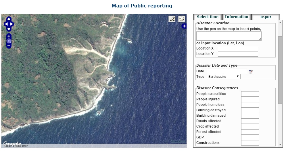
There is a need to develop a national landslide database, which requires that one organization is made responsible for generating and maintaining such a database, and where several other organizations should contribute. This will require additional funding from a donor agency to set it up. Perhaps the best approach is to organize this regionally, e.g. with the help of CDEMA, and with expert help from organizations like the University of the West-Indies and international experts. The landslide inventory should be stored in a web-mapping application, with a Google Earth or other background, where various national and international organizations can consult the existing landslide information, and where new landslide events can be added by government organizations, local people, news media, NGO's etc. A close collaboration with the online newsmedia is highly recommended, as they have reported many landslide events, with additional photo or video footage, which could be easily linked to a geolocation, and stored in such a database so that the information is not lost. It is very important to get better data on the location, type, damage and especially the date of landslide events, so that in future a correlation between rainfall characteristics and landslide incidences, and the establishment of rainfall thresholds, and frequency/magnitude relationships can be properly carried out. These reported events would be stored in a separate database, which is used by the national responsible organization for landslide inventory mapping, as the basis for checking. These are added to the actual database only after they have been checking by an expert. This will also allow the continuation of the landslide database in future. It is essential that there is a close collaboration between the various national organizations that have to deal with landslides. However, one organization should be the nodal agency responsible for setting-up the national landslide database.
Figure: Example of a landslide reporting application and landslide database developed in another region (http://drm.cenn.org/index.php/en/disaster-reporting/public-reporting)
- Landslide inventory mapping based on visual image interpretation and fieldwork.
Sometime after the occurrence of major events, when the relief efforts have been concluded, and when reconstruction activities are taking place, it is also important to organize the landslides that were generated during this event in a coherent manner. The landslide inventories that are generated directly after an event using object-oriented image classification methods by international organization generally need to be improved in order to be able to use them properly later for improving landslide susceptibility and hazard maps. Therefore it is required to carry out visual image interpretation. Visual image interpretation can focus on smaller areas, where results from the image classification have already provided possible landslide polygons. But also for areas where clouds and shadows make the semi-automatic image classification method difficult. The visual image interpretation should ideally be done using stereo-image interpretation by expert interpreters, which could be consultants, or staff and students from interested Universities. They are also able to characterize the landslide polygons with a number of the characteristics described below, and they can prioritize the landslides that should be field-checked. Training is required for obtaining reliable results, and cross validation is also important. Field checking is expensive and time consuming, and therefore field checking should be based on the results of the visual image interpretation, or through landslide emergency information received from local authorities, NGO's, local people, and should focus initially on landslide areas around settlements or infrastructure. The detailed description of some of the characteristics described below can only be obtained through field checking.
Proposed method for landslide inventory mapping
The landslide inventory mapping should follow the following requirements:
- Landslides should be mapped on 1:10.000 scale. When using satellite images, landslides should be mapped on georeferenced and ortho-rectified images at that scale. This scale is appropriate for local assessment of the effects, and as a basis for local hazard assessment. However, the accuracy of the ortho-rectification at this scale requires good positional information on the ground). Otherwise, the mapping may appear good, but it is actually not accurate
- Landslides should be validated using visual image interpretation by landslide experts. The use of (semi) automatic landslide inventory assessment from satellite images is good to obtain a rapid overview of possible problem areas, and some of the algorithms used (e.g. by CNR-IRPI) provide reliable results as to the landslide areas, but careful validation is needed by experts in image interpretation to avoid mistakes, or omission of landslides, and a correct classification with respect to the type and age. The landslide database should indicate who interpreted the landslide.
- Landslides should be checked in the field. In the generation of the landslide inventory map it is important to check the landslide in the field, and to collect a number of characteristics that are not possible to determine from image interpretation alone. However, field checking is time consuming and expensive. The landslide inventory database should indicate which landslides are field checked, when and by whom. It may not be required that all the landslides are checked in the field, and for overall mapping only 5% or even 2% of the landslides should be checked in the field. However, landslides that are close to settlement areas or infrastructure should always be checked in the field.
- Landslides should be mapped as polygons, and not as points. Only by mapping the landslides as polygons it is possible to analyse their area, and volume, which are important for hazard assessment, especially for deep-seated landslides. Existing point-based inventories should be converted into polygon-based ones.
- Landslide polygons should separate the initiation areas from the runout areas. This is important as well for the hazard assessment.
- Landslides should be mapped individually and not as groups. The identification of individual landslides is important, but could sometimes be difficult if landslide might merge downslope into common accumulation areas. This allows a better identification of the causal factors, and an improved landslide hazard assessment. Where separation of the single landslides cannot be done, this should be clear on the map as it may affect the landslide susceptibility / hazard modelling
- For a better exchange between different computer platforms landslide polygons should be mapped as single polygons using vector format (e.g. shapefiles), where each landslide should have a unique identifier, and should have the following attributes:
- Type of landslide (following the standard Cruden and Varnes classification (1996);
Initiation or accumulation area (to differentiate between initiation and accumulation areas);
- Depth of landslide in 2 simple classes (shallow, deep). This is difficult to do, although very important and may only be properly done based on field validation. It will require training of the field teams to reduce the subjectivity as much as possible;
- Volume of landslide (can be calculated in GIS by multiplying depth with area);
- Blocking river (indicate if the landslide blocked the drainage, in 4 simple classes). Here the temporal information is important. When mapping the earthquake-induced landslides it should be indicated if the landslides blocked the river (partially or completely) even though afterwards the landslide dam may have been broken through.
- Landslide damage (text information about observed damage. Detailed damage assessment should be done in separate form). This can only be done for landslides that were actually validated in the field, but it is an important characteristics that should be used in the risk assessment later;
- Remarks (text field to indicate any remarks)
- Mapped by (important to indicate the person who carried out the mapping). If there is a supervision of the work, the name of the supervisor should be listed also.
- Hazard potential (Indicating the subjective evaluation of the possible hazard that this landslide might pose in future).
- Landslide inventory maps should be made for different time periods:
This is important but may not be simple to achieve. It is important that the inventory contains the information (including the temporal information, e.g. time of the imagery / filed work) used to prepare the maps. From this information one can classify the inventory according to the classes given below. It is also important to provide information on the time used to prepare the single inventories.
- Landslide type classification should follow the Cruden and Varnes (1996) classification.
|
|
Movement type |
|||
|---|---|---|---|---|
|
Slide |
Flow |
Fall |
||
|
Material involved |
Earth |
Earth slide
|
Earth flow |
Earth fall |
|
Debris |
Debris slide
|
Debris flow
|
Debris fall |
|
|
Rock |
Rock slide
|
|
Rock fall |
|
Combination of landslide types. It is very common that the initiation part of the landslide has a different type classification than the run-out / accumulation part of the landslide. This is taken into account in the design of the database. There may also be cases where the scarp area or the accumulation area consists of two types, and then the user should indicate the combination of the types.
- Depth classification should follow a simple classification:
- Shallow: less than 5 meters
- Deep: more than 5 meters
Characterization of landslide depth is always a difficult work, and can be subjective. Therefore training is important, and a set of examples should be prepared.
- Blocking river characteristics. It is also important to indicate which landslides have partially or completely blocked rivers.
- None (no signs of blockage of rivers)
- Partially (the landslide has partially blocked the river)
- Complete (the landslide has completely blocked the river, and the blocking is still there)
- Complete and broken through (the landslide has blocked the river but the landslide dam is broken through later)
- Information on the landslide volume is difficult to assess in the field, and can be best calculated in GIS by multiplying the average depth with the area of the landslide. Here it is also important to map the landslides as individual features and not as large zones, as this will overestimate the volumes considerably. Separate volumes of initiation and accumulation should be calculated.
- Landslide damage information can be added as text field in the database, using both information from the image interpretation as well as from the field check. It is advised to use a separate field checklist to mark the observed damage in detail.
- It is important to indicate who mapped the landslide, so that it is possible to contact the person in case of confusion.
- It is also important to indicate who carried out the field checking of the landslide, and the date when the landslide was checked in the field. This is particularly important as the characteristics might have changed between the different periods.
- Hazard potential. The hazard potential refers to the possible expected future landslide activity. It is important to indicate this separately for the scarp area and for the accumulation areas. It is very important to indicate the hazard potential in both the interpretation phase as well as in the field checking. This evaluation is related to the expected activity of the landslide in future and its potential to create additional damage. It is advised to use a rather simple classification, for example in three classes, where each of the classes contains a description of the actual reasons (preferably in the remarks field):
- Low: there is limited danger that the landslide might become problematic in future. It is probably a single event.
- Moderate: there is a moderate danger that the landslide might become problematic in future.
- High: there is high danger that the landslide might be re-activated in future and increase in size or become more destructive.
- Remarks. It is advised to have a text field where all remarks can be stored that are given by the interpreter and the field checker. This should be a relatively large text block, where all relevant observations concerning the landslide can be stored.
The following figure illustrates the above mentioned points:
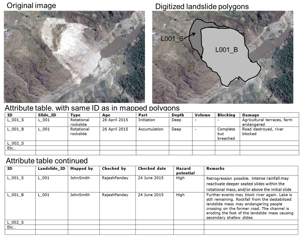
Figure: Illustration of proposed landslide inventory method
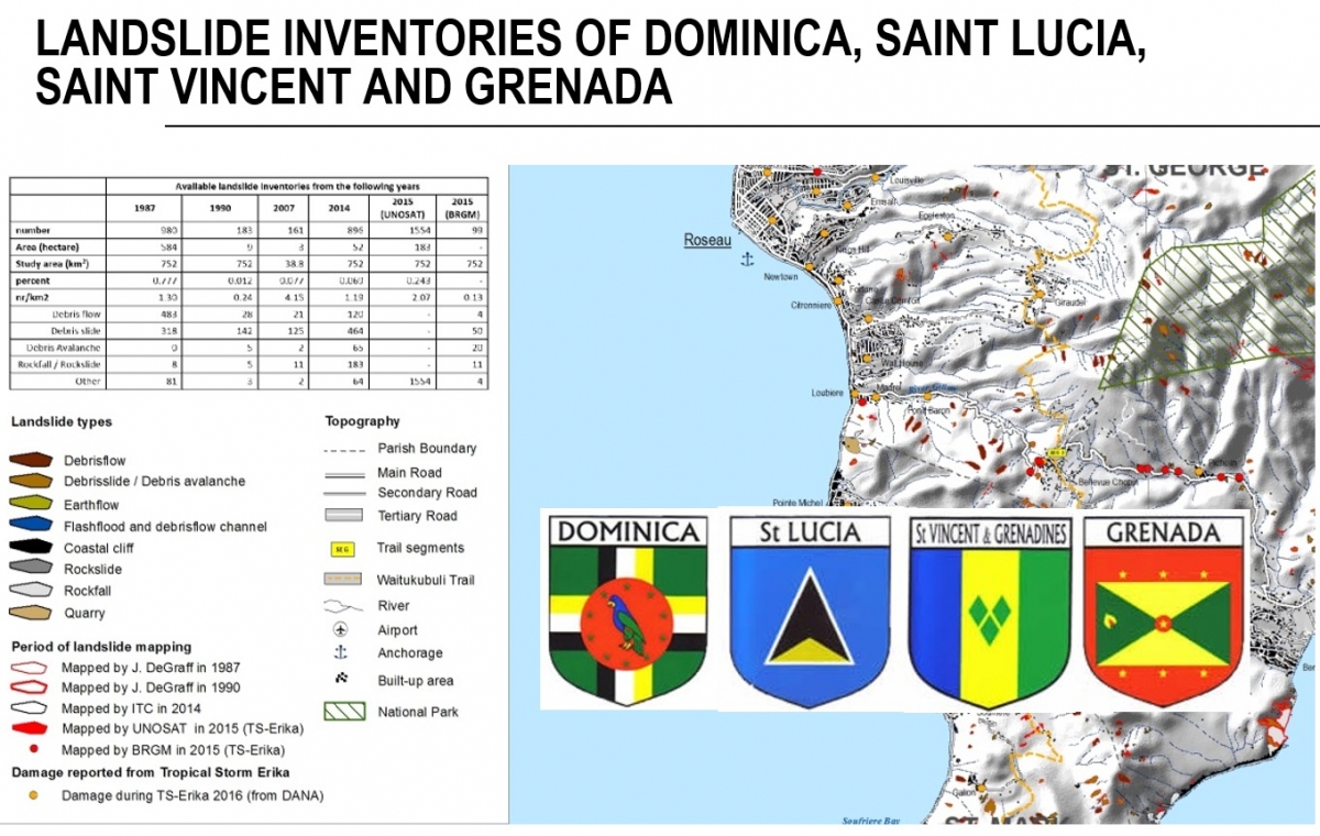
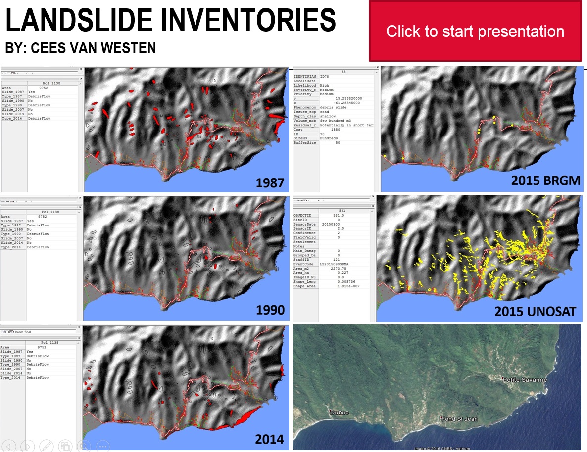
Landslide inventories in Dominica, Saint Lucia, Saint Vincent and Grenada.
Within the CHARIM project landslide inventories have been produced for 4 Caribbean islands.
View the inventory map for Dominica
View the inventory map for Saint Lucia
View the inventory map for Saint Vincent
View the inventory map for Grenada