

Which Planning tools are useful for risk reduction and how hazard and risk information is used; building permits, building codes; restricted areas. which procedures are followed for building control and how hazard and risk information can play a role in this?
Authors: Naveed anwar and Charisse Griffith-Charles
Links:
Introduction
The impact of natural hazards such as flood, landslide, hurricane or earthquake on society and the environment determines the severity of the disaster. In other words, a disaster is result of a community's vulnerability. Disaster risk can be determined by the presence of three variables: hazards; vulnerability to a hazard; and coping capacity linked to the reduction, mitigation and resilience.
Risk= Hazard x Vulnerability/Capacity
Vulnerability is the potential to suffer harm or loss, related to the capacity to anticipate a hazard, cope with it, resist it and recover from its impact. Both vulnerability and its antithesis: resilience are determined by physical, environmental, social, economic, political, cultural and institutional factors.
Disaster Risk Reduction (DRR) is a conceptual framework intended to systematically avoid (prevent) and limit (prepare/mitigate) disaster risks with regard to losses in lives and the social, economic and environmental assets of communities and countries.[1] Reducing exposure to hazards, lessen vulnerability of people and property, wise management of land and the environment, improving preparedness and early warning for adverse events are all examples of disaster risk reduction. [2] Disaster Risk Management (DRM) includes but goes beyond DRR by adding a management perspective that combines prevention, mitigation and preparedness with response.
A considerable share of human and direct economic losses from natural hazard events occur as a direct result of damage to the built environment, in turn reflecting poor construction and sometimes inappropriate land use. Positive planning has an important role in helping deliver sustainable development. Hazard and Risk information is used for decision making, data collection and analysis should begin at the earliest possible stage of land use planning to generate hazard and land use maps and to implement procedures for building control.
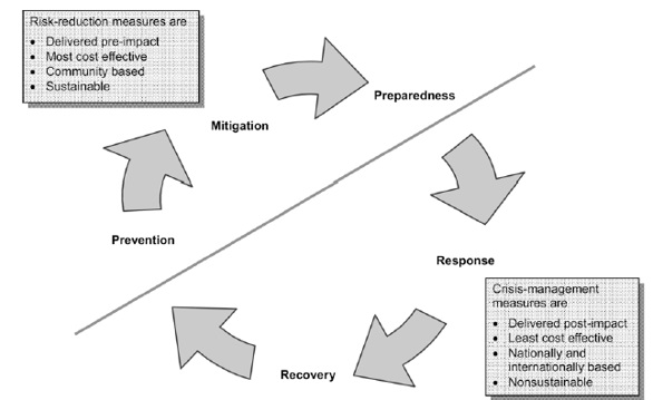
Figure 1: A diagram of the disaster risk management cycle comparing risk-reduction measures
Broadly, disaster risk reduction includes efforts to:
- Foster or support national, provincial or local prioritisation and coordination of disaster risk reduction strategies
- Collect data on natural hazard risks for use in improving early warning systems
- Educate and raise awareness about disaster risk reduction
- Mitigate the impact of natural hazards, through livelihood diversification, building reinforcement, environmental protection, microfinance, land-use planning and any other activities that increase resilience
- Strengthen disaster preparedness, including contingency planning, emergency response and evacuation plans
Risk Reduction Tools
DRR tools have been developed by a number of institutions, including research centres, government agencies, the UN, NGOs, and IGOs. These include tools targeted for use at both the international and local levels, implemented in cooperation with diverse partners, and in response to numerous hazards.
Policy, Coordination and institutions
This category includes the country's overall policies, the legislative process, and the institutional framework for implementing measures. The tools that have been developed for policy and institutions are aimed at mainstreaming disaster risk reduction into development planning from the national to community level. Due to their comprehensive nature, these tools focus on the process of decision-making.
Through integration with existing development plans, the disaster risk reduction strategies explicitly support national goals. Furthermore, the process outlined in these tools is multidisciplinary, so that planners clearly see how activities in one sector may influence risks in another. These tools can be utilized at various levels so that commitment is built throughout the system. For example, SOPAC's Comprehensive Hazard and Risk Management (CHARM) is implemented through a series of workshops aimed at broad stakeholder consultations at the national and regional levels.
|
Comprehensive Hazard and Risk Management (CHARM) |
|
|---|---|
|
Description |
CHARM is defined as a comprehensive hazard and risk management tool for use within an integrated national development planning process. It aims to facilitate greater collaboration between risk reduction projects at all levels (though mostly at the national level with participation from stakeholders for decision-making) and across sectors to enhance sustainable development. CHARM takes all hazards into account across the whole country. |
|
Appropriate Use |
This tool can be used for mainstreaming disaster risk reduction into ongoing national development planning processes. It aims to address all hazards including natural and human-induced, and also aims to help identify measures that can be implemented in all phases of disaster management (prevention, preparedness, response, and recovery). The emphasis is on bringing a wide range of stakeholders together for risk reduction to enhance effectiveness of the combined efforts. |
|
Scope |
National Level |
|
Key Output |
The immediate output of the CHARM process is to develop a matrix summarizing national risks and risk reduction measures (or "treatment options") that considers the activities of all agencies. Planners then target the gaps identified in the matrix. Step 1 - Context established; Step 2 - Risks identified; Step 3 - Risks analyzed; Step 4 - Risks evaluated; Step 5 - Risks treated and results evaluated. |
|
Key input |
Step 1 - Identification of national development priorities, organizational issues, and initial risk evaluation criteria; Step 2 - Identification of hazard, vulnerable sectors, and impacts; Step 3 - Assessment of risks with stakeholders based on agreed indicators, such as frequency of hazards, potential impacts, etc.; Step 4 - Determination of acceptable levels of risks and priorities for action; Step 5 - Selection of risk reduction measures; assignment of roles and responsibilities for all partners; evaluation against agreed criteria. |
|
Ease of use |
Readily usable by those with experience in policy analysis, developing work plans, and inter-agency planning. |
|
Training required |
Knowledge of tools for each step is needed (e.g. to rank development challenges, develop budgets). |
|
Application |
CHARM has been used for planning in Palau, Kiribati, Vanuatu, Fiji, and Tonga, and it has also been aligned to the Joint Australia-New Zealand Risk Management Standard. |
Preparedness and early warning systems
The tools for risk identification may include national assessments to gain a broad understanding of risk for entire sectors or geographical regions. Or, as shown in ADPC's Community-Based Disaster Risk Management Field Practitioners' Handbook, a tool can provide a framework for assessment teams working in a participatory manner with individual communities. Local knowledge is combined with scientific understanding and advanced technologies to generate a fuller picture of risks.
|
Asian Disaster Preparedness Center (ADPC)'s Community-Based Disaster Risk Management Field Practitioners' Handbook |
|
|---|---|
|
Description |
The handbook briefly explains the concept of community-based disaster risk management (CBDRM) and provides practical tools that can be applied in community-level programming. The Handbook is divided into four parts: 1) an introduction to CBDRM; 2) specific step-by-step exercises; 3) crosscutting issues of gender and communication; 4) disaster risks in Southeast Asia The tools in Section 2 cover seven types of activities in CBDRM: 1. Selecting the community 2. Rapport building and understanding the community 3. Participatory disaster risk assessment 4. Participatory disaster risk management planning 5. Building/training a community disaster risk management organization (CDRMO) 6. Community-managed implementation 7. Participatory monitoring and evaluation The resource pack for risk identification (Step 3) includes instructions and guiding questions for the most commonly used participatory assessment tools, e.g. constructing timelines, hazard maps, rankings, and calendars. |
|
Appropriate Use |
This handbook is a comprehensive how-to guide that can be used to assist project teams working at the local level to ensure the participation of community members in reducing disaster risks. Each of the seven steps, particularly Step 3, is clearly outlined, along with simple instructions for group exercises, information to gather, and stakeholders to involve. |
|
Scope |
Community Level |
|
Key Output |
Overall: "The CBDRM process should lead to progressive improvements in public safety and community disaster resilience. It should contribute to equitable and sustainable community development in the long term." Step 1 - Priority vulnerable communities identified Step 2 - Trust between community and project members; understanding of community needs among project members Step 3 - Disaster risks identified and community members understand these risks Step 4 - Community disaster risk management plan Step 5 - CDRMO established and equipped with skills to implement their disaster risk management plan Step 6 - Planned activities implemented effectively and on time, with participation of stakeholders Step 7 - Appropriate indicators of program success developed and progress measured, with participation of stakeholders |
|
Key input |
Information on various criteria developed by decision makers Step 2 - Information about the community and efforts to develop relationships/understanding with community members Step 3 - Range of qualitative and quantitative data about the hazards, vulnerabilities, and capacities in the community Step 4 - Dialogue among stakeholders to identify needed measures Step 5 - Identification of CDRMO members and training Step 6 - Responsibilities carried out by members; periodic reviews Step 7 - Range of qualitative and quantitative data about activities' impacts; dialogue between stakeholders. |
|
Ease of use |
Readily usable |
|
Training required |
Some training or experience in working at the local level would be useful |
|
Application |
This methodology has been used in several communities throughout South and Southeast Asia. |
Awareness, Education and Knowledge management.
Supporting the local community's involvement is crucial for implementing strategies that will lead to a culture of safety. This area of disaster risk reduction includes managing the information and data that has been gathered, educating people about the risks, and building people's capacity to devise and implement risk reduction measures. The information and knowledge should not flow in only one direction; planners must also learn about the community's needs and wants so that they can better support development and risk reduction. These experiences can then be shared with other communities and successes replicated
|
EMA's The Good Practice Guide: Community awareness and education in emergency management |
|
|---|---|
|
Description |
During the emergency period, a well-prepared community can reduce the impacts from the disaster. Community members often play a large role in providing relief for each other. This tool presents best practices, ideas, plans, and suggestions for educating the community on disaster preparedness, rather than a how-to guide on communications. The broad framework can be easily adapted for specific communities. The guide provides the following information: 1. Introduction to the issue and how to get people's attention 2. Planning a campaign, with information on a range of communication tactics 3. Evaluating a campaign 4. Working with the media, partners and sponsors, and the community 5. Information resources |
|
Appropriate Use |
The guide aims to assist in planning and implementing community awareness and education campaigns. It is aimed at local government authorities, health services, police, fire services, schools, and other community organizations. It lays out the basic steps of an awareness campaign, describes communication tactics (e.g. print/electronic communications, giveaways, special events, etc.) and outlines a method for evaluating the campaign's performance. |
|
Scope |
Local Level |
|
Key Output |
Step 1 - Target audience identified Step 2 - Target audience's needs and wants identified Step 3 - Key message developed Step 4 - Measurable objectives identified Step 5 - Tactics chosen Step 6 - Required resources secured Step 7 - Awareness and education campaign implemented Step 8 - Awareness and education campaign evaluated and documented results available |
|
Key input |
Step 1 - Information on vulnerable groups and potential partners in reaching them Step 2 - Discussions with community representatives and members; Review of existing sources of information (newspapers, radio, etc.) Step 3 - Identification of hazards and priority messages Step 4 - Development of campaign objectives and concrete indicators to measure changes Step 5 - Identification of effective information sources and delivery methods for the target audience, as well as the required resources Step 6 - Partnerships developed; Information on available staff and financial resources Step 7 - Commitment of staff and volunteers; Definition of roles, responsibilities, and a timetable for activities Step 8 - Review of the campaign against indicators, e.g. through surveys, observation, or discussions |
|
Ease of use |
Readily usable |
|
Training required |
None |
|
Application |
Based on EMA's experience in Australia, but easily adaptable to other contexts. |
Risk Management Applications
This type of DRR tool is by necessity sector-focused because the tools aim to develop concrete, detailed measures. This normally involves specialized knowledge and skills. The Pan American Health Organization (PAHO)'s guidelines, which have been used throughout Latin America and the Caribbean, focus on drinking water and sewerage systems.
|
Pan American Health Organization (PAHO)'s Natural Disaster Mitigation in Drinking Water and Sewerage Systems: Guidelines for Vulnerability Analysis |
|
|---|---|
|
Description |
These guidelines provide the basic tools to evaluate the vulnerability of a drinking and sewerage system to various natural hazards. These systems are vital to development, as well as to ensuring a return to normalcy following a disaster. Conducting this vulnerability analysis helps identify preparedness and mitigation measures to limit risks. It also identifies the response mechanisms that should be put into action in the event of a disaster. The risk of damage to water systems increases with factors such as uncontrolled growth in urban areas, deficiencies in infrastructure, and climate change. The guide is divided into four sections:
|
|
Appropriate Use |
The tool is ideally used during the disaster preparedness phase to identify and implement mitigation measures. It is aimed at engineers and technical personnel of water service companies to project how the water systems will perform in the event of the disaster and to minimize damage. Vulnerability and probabilities of damage are expressed as various formulae. The guide provides an overview for each section with issues to consider at each step. It also includes checklists (e.g. Characteristics of an emergency operations center and the emergency committee; Components of an emergency response plan), matrices to describe system vulnerabilities (formats provided in annexes), and extensive information on impacts on water systems from earthquakes, volcanoes, hurricanes, floods, etc. |
|
Scope |
Water systems (with coverage being sub-national, municipal, etc.) |
|
Key Output |
Planning - Emergency committee established within the water company, with roles and responsibilities defined; Emergency operations center established; Partnerships with national organizations established.
|
|
Key input |
Planning - Information on: national standards, institutional coordination, and resources available for preparedness and response; and dialogue with partners
|
|
Ease of use |
Can be used as an overview for the emergency committee, although the vulnerability analysis should be conducted by a team of specialists. |
|
Training required |
Vulnerability analysis requires extensive experience in the design, operation, maintenance, and repair of a drinking water and sewerage system's components. |
|
Application |
Used throughout Latin America and the Caribbean. Case study in documentation from Limon, Costa Rica, to assess earthquake vulnerability. |
Preparedness and Response
DRR preparedness and response tools are often used ahead of a disaster to be ready when a hazard strikes.
|
IFRC's Guidelines for Emergency Assessment |
|
|---|---|
|
Description |
These guidelines provide advice on the organization of emergency assessments, starting with an introduction of key concepts and then outlining each step. The steps are roughly laid out in the order required during an assessment. The chapter on fieldwork notes some basic principles that should underlie activities, such as participation, inclusion or marginal groups, looking out for biases, etc. Results of the general assessment can indicate where more technical assessment is needed. The framework can be easily adapted to incorporate climate change issues as it provides fairly general guidelines on the assessment process. |
|
Appropriate Use |
Aimed at generalists in the Red Cross Red Crescent community conducting an assessment to provide an overview of the situation. The guidelines cover the following steps, some of which would overlap:
The chapter on fieldwork includes detailed descriptions of various types of information gathering exercises and issues to consider for each one, including tips on establishing trust, cultural sensitivities, suggested questions, and extensive checklists that were compiled by sector specialists. It gives very clear, easily understandable directions for carrying out activities. |
|
Scope |
Local affected areas |
|
Key Output |
Planning - Determination of whether an assessment is needed, objectives and terms of reference, and type of assessment (rapid/detailed/continual).
|
|
Key input |
The guidelines recommend that each of these steps are generally undertaken sequentially, so that the output of the planning phase is used as an input to the office-based tasks, and so on.
|
|
Ease of use |
Readily usable by anyone conducting an assessment. |
|
Training required |
None |
|
Application |
Based on IFRC's experience in conducting assessments following disasters around the world. |
how hazard and risk information is used; building permits, building codes; restricted areas.
Hazard and Risk Identification, analysis and assessment
Understanding hazard and risk is a vital component of DRM and provides basis for decision making. Quantitative estimation of potential damage is important as it informs the appropriate strategies and measures to be taken. Risk assessments require hazard, exposure, and vulnerability data at the appropriate scale to address the problem of interest.
Risk exposure data should be collected, mapped, and shared as they are essential components of risk assessment and to avoid inappropriate development in restricted areas. Hazard and risk assessment should be revised and updated periodically with the latest findings and in light of more recently experienced disasters.
Hazard and Risk Information can be obtained and analysed through the following steps:
Hazard Classification
The management of hazards depends greatly on our understanding of the phenomenon. A global review of disaster reduction initiatives" (UNISDR 2002:44) chooses to classify hazards in the following three categories:
- Natural hazards;
- Technological hazards; and
- Environmental degradation.
Hazards can be single, sequential or combined in their origins or effects. Some hazards may have a natural or human-induced origin.
Information on the following key features of natural hazards is also needed to identify past, present and potential hazards and their effects:
- Location and extent.
- Frequency and probability of occurrence.
- Intensity/severity.
- Duration.
- Predictability.
Moreover, significant advances have been made in generation of synthetic catalogues of hazard events, which are used to ensure that the full range of hazard events is captured and the likelihood of different events assigned.
Hazard Mapping and Zoning
Hazard maps provide important information to help people understand the risks of natural hazards and to help mitigate disasters. The information provided on the maps needs to be clear and adequately explained to the users. Risk information must be communicated to planning authorities effectively to avoid inappropriate construction in vulnerable zones.
Hazard maps indicate the extent of expected risk areas, and can be combined with disaster management information such as evacuation sites, evacuation routes, and so forth. Hazard information with evacuation routes and locations of evacuation centres, are effective tools for promoting evacuation procedures and risk awareness among the public. They should be easy to understand and readily available.
The level of hazard to be used in designing structural measures should be selected based on local conditions. Data preparedness is a key ingredient for both pre-event disaster risk management and post-event damage assessment and reconstruction planning. Data collection on key infrastructure should be carried out during normal times and kept up to date. The data can be used for other purposes such as town planning. Satellite images and aerial photographs are now routinely used for hazard mapping.
Risk Assessment and Analysis
A disaster-related risk assessment provides an opportunity before a disaster event to determine the deaths, damages, and losses that will result and to highlight which actions will be most effective in reducing the impact on individuals, communities, and governments. This ability to estimate potential disaster loss and to provide analysis on the costs and benefits of risk preparedness, reduction, and avoidance has made disaster risk assessments a powerful tool in disaster risk management (DRM).
Both structural (i.e., physical) vulnerability and socioeconomic vulnerability are relevant to risk assessment.
which procedures are followed for building control and how hazard and risk information can play a role in this?
Informing policies, investments, and structural and non-structural measures intended to reduce risk. Hazard and risk information may be used in broad range of activities to reduce risk, from improving building codes and designing risk reduction measures, to carrying out macro-level assessments of the risks to different types of buildings (for example, for prioritizing investment in reconstruction and retrofitting). Safer building codes, land use, and quality control through regular monitoring and inspection procedures are important amongst structural measures while creating DRR awareness, planning, training and capacity building of all stakeholders, especially the community and government departments are important.
In the construction sector, quantifying the potential risk expected in the lifetime of a building, bridge, or critical facility drives the creation and modification of building codes.
Recent earthquakes in Chile, New Zealand, and Japan have demonstrated the influence of enforced building codes in reducing death, damage, and loss. There must be robust and accessible information on hazard, exposure, and vulnerability models that integrate this information and quantify risk, and the commitment and resources to prioritize actions needed to implement risk reduction.
Skilled engineers, architects and builders with effective enforcement and inspection procedures are required for the correct application of building codes. If appropriate building codes are not implemented due to corruption, for example, abuse of land use controls and building permits and codes, and illegal expansion of buildings often exacerbate damage caused by disasters.
Building Permits
The purpose of a building permit is to notify the local municipality that work is being performed and prompts an inspection to ensure that minimum standards to safeguard life, health, property and public welfare are maintained and followed.
Procedures for Building controls
All building work carried out should meet current building codes and regulation requirements. Building Control procedures ensures that buildings are designed and constructed in accordance with the Building Regulations and associated legislation.
It is the responsibility of personnel carrying out the work to ensure that the provisions of the regulations are fully met. The role of Building Control is only to check that they do so.
The building controls are typically carried out at the following levels:
-
Development of appropriate building codes and regulations to be followed, including the definition of building types and occupancy categories.
-
Development of zoning maps and regulations to control what type of buildings, number of storeys, building height, occupancy and usage are permitted in various locations.
-
Defining procedures for obtaining pre-building permissions and permits and approvals for starting the project. This may contain environmental, social safeguard and other considerations, such as hazards.
-
Evaluation and approvals of building designs including public hearings and community feedbacks, this may involve review of structural design, fire safety, and health issues and may include explicit considerations for disaster reduction.
-
Site inspections during construction and conformance to building and construction by-laws.
-
Final permit to occupy the building.
References
- KNOWLEDGE NOTE 5-1, CLUSTER 5: Hazard and Risk Information, and Decision Making, GFDRR, and The World Bank.
- Community based disaster risk reduction planning tool, inter cooperation, Swiss Foundation for Development and International Cooperation, Swiss Cooperation Office, Dhaka
- Tools and Methods, Inter-Agency Task Force Working Group on Climate Change and Disaster Risk Reduction Tools for Mainstreaming Disaster Risk Reduction: Guidance Notes for Development Organisations, Charlotte Benson and John Twigg with Tiziana Rossetto, January 2007, Website: www.proventionconsortium.org
- Extract from Australian Geomechanics Journal and News of the Australian Geomechanics Society Volume 42 No 1 March 2007, " A national Landslide Risk Management Framework for Australia".
- UK PLANNING POLICY STATEMENT 25 PRACTICE GUIDE, Development and Flood Practice Guide, December 2009.
- Understanding risk, The Evolution of Disaster Risk Assessment, Global Facility For Disaster Reduction and Recovery