

Construction on land for residential, commercial or other purposes can, by either restricting or increasing runoff of rainfall, cause or exacerbate the damaging impact of flooding and landslides. The construction itself, the occupants, and the surrounding community can be placed at risk at that location for the impacts of floods and landslides. Plans for construction must therefore only be approved if those plans follow strict regulations for location, and design of construction that would protect the construction, the occupants, and the community from impacts of flooding and landslide. This use case provides an understanding of how an application for building can be assessed by physical planning authorities to determine whether the proposed construction should be approved, modified, or denied. The location of the proposed construction must be assessed to determine the level of risk from flood and landslide hazards, and the design and construction material specifications must be assessed to determine whether they can mitigate or prevent injury, damage, and destruction due to landslides and floods. The planning is guided by documented specifications determined by civil or structural engineers, or mapping of risk provided by drainage engineers with knowledge of hydrology and soils. In the absence of these prepared guides, planning must be a multi-disciplinary process with case by case inputs from professionals with the required knowledge. To illustrate the optimal theoretical process, an ideal application for permission to build a small residential building is described indicating where the assessment of landslide and flood risk should be incorporated in the procedure.
Keywords:
Land use, planning, building control, slope, soil
| Before you start: | Use case Location: | Uses GIS data: | Authors: |
|---|---|---|---|
| Read Methodology book chapter 7 | Generic | No |
Charisse Griffith-Charles |
Introduction:
The construction of a building involves decision making on the location of the building and also the design of the building inclusive of the materials and construction methods used. The location and design of the building should therefore be guided by specifications that consider the risk of flood and landslides at the particular location by looking separately at criteria for determining the risk of flood and the risk of landslide, including the historical incidence of these events as well. Data on rainfall, topographical characteristics such as elevation and slope, and geomorphological characteristics such as soil and rock strength and porosity are all required for an analysis of risk. These two issues of location and design are illustrated in the picture at Figure 1 of flooding in a residential area in St. Lucia. Planning authorities should not approve construction of residences in areas at high risk for flooding and landslide. If construction is allowed in areas of medium risk, the design of drainage and building should mitigate the level of impact of the flooding on the building and its occupants as much as is possible. These designs should be specified in a building code that can guide the land use planner to assess the application. The set of rules that specify the minimum standards for constructed objects such as buildings and non-building structures is called a building code. Building codes are developed by civil, drainage, and structural engineers to treat with the particular characteristics of an environment in the construction of built development. Building codes should include standards that address the risk of landslides and floods. See Chapters 3.2.1 Design Guidelines for Buildings, 3.3.1 Critical Infrastructure Planning Relocation for Buildings, Roads, and Other Infrastructure, and 3.3.2 Design Guidelines for Buildings, Roads in Flood Areas and Roads in Landslide Areas for more details, from an engineering perspective, on mitigation measures that are possible to address landslides and floods.
The current land use planning processes for building control that occur in Grenada, Saint Lucia, Dominica, and St. Vincent and the Grenadines do not incorporate hazard and risk information. Belize does incorporate some investigation of risk as it relates to floods. There is also an Organisation of Eastern Caribbean States (OECS) Building Code that takes into consideration the potential impact of hurricanes, earthquakes, and floods in building construction.
The following process for review of application for building development describes a theoretical process where data on hazard and risk of flooding and landslides is incorporated. Suggestions are made about how to proceed with assessing the application when there is insufficient data to make a determination.
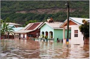
Photograph of flooding in residential area of St. Lucia (Image credit)
Objectives:
The objectives of this use case are to:
- Provide a clear ideal structure for the building approval process and indicate where in the processing of the application for permission to build that landslide and flood information can be incorporated.
- Provide suggestions for assessing applications for building development, under current data availability which is less than the ideal.
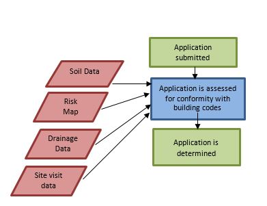
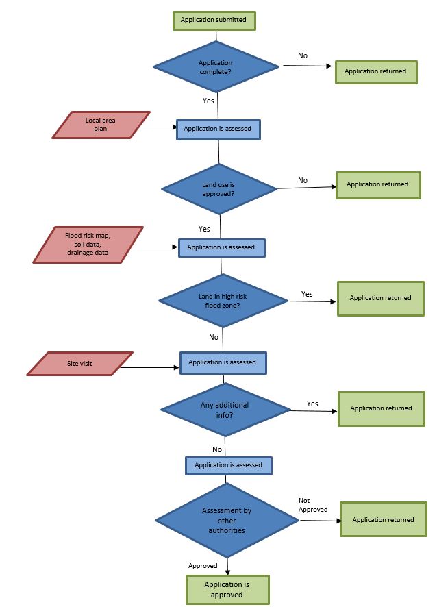
Flowchart:
Simple Flowchart
More Detailed Flowchart
Problems definition and specifications:
A landowner would like to construct a small residence on a parcel and therefore makes an application for permission to do so. The planning authority requires a procedure to assess the application that would consider the risk of flooding and landslides both in the location of the proposed construction and in the design and construction methods to be used. It is important to determine the risk of flooding from looking at a range of factors. It is also important to ensure that the building is constructed so that the risk of flooding does not establish or increase. Adequate drainage is required to account for current drainage requirements and increased future drainage needs. Knowledge of soil and slope conditions and how these affect the risk of landslides is required. Specifications for construction that would mitigate different levels of potential flooding and landslides are also required. The engineer uses these data to prepare specifications that would guide the land use planner in the approval process. If such specifications are not documented to which the land use planner can refer, then the assessment must be a multi-disciplinary one where the building application is passed to an engineer for input toward the approval or rejection by the planner.
Data requirements:
The list of data required includes:
- National Land Use Plan
- Local Area Land Use Plan
- Flood Risk Map
- Building Codes
- Topographic Map
- Proposed building plan
National Plan
At the national level there should ideally be a national plan at scales of 1: 50,000 that would indicate if subdivision for development is desirable for the particular area for which the application is submitted. Broad areas of residential, agricultural, environmental reserve, and industrial uses can be illustrated at this scale. Figure 1 shows an example of a national plan at a broad scale. See Use Case 2.1. National Land Use Plan which illustrates the process for preparation of a National Land Use Plan. Flood and landslide risks should be taken into consideration in the preparation of a National Physical Plan.
In the absence of an approved national plan there should be verbally stated policies that can be followed and that fit in with a national land policy. The land policy dictates, at broad scale, the direction , goals, and objectives of the country as it pertains to land use and allocation.
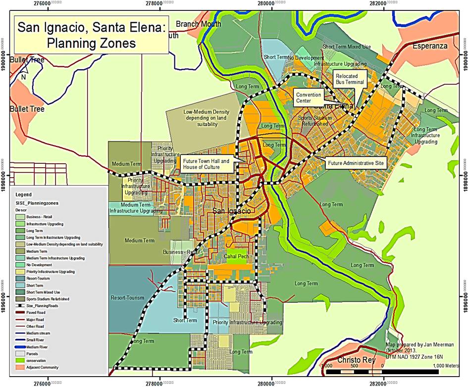
Figure 1. Example of Plan from Belize
Local Area Plan
Local area plans should be available at larger scales than the national plan. These can be at 1:10,000 and contain information on a settlement or community and how all the necessary amenities are distributed within that area.
Local Area Plans are lowest in the hierarchy of development plans, coming after National Land Use Plans and Regional Land Use Plans. They are, however, prepared at the largest scales of all plans and contain more precise and more copious detail. Local area plans require, for preparation and revision, policy data, built infrastructure data, natural topographic and land cover data, and social demographic data. Hazard information should be incorporated into the creation of these plans and various levels of risk should be indicated. Local area plans should be available to guide the approval of application for subdivision process. Figure 2 shows a local area plan with planning zones. See Use Case 2.2 Local Land Use Planning for more detail on the preparation of local land use plans that take hazards and risk into consideration.
In the absence of a local area plan, the Planning Department should have policies about how land is to be allocated for various uses, equitably, within the immediate community.This process should be guided by the data on soils, topography and drainage among other data. If there is none, for the immediate vicinity of the location of the proposed development, the applicant must be asked to supply topographic data at 1:500 scale from which slopes can be calculated. Buildings should not be entertained beyond a slope steeper than 30 degrees as this will create or exacerbate, the risk of landslides. Buildings should not be entertained below a height of 5m above mean sea level as this situation is at risk of flooding.
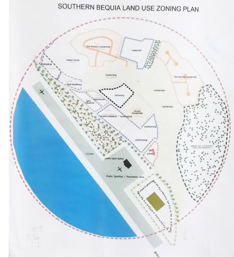
Figure 2. Land use zoning plan for Bequia
Flood Risk Map or Flood Hazard Information
Flood risk maps at a large local scale of 1:10,000 may be necessary to determine the risk of building within a community. Flood risk maps can be produced from analyzing existing hazards and creating a risk model. See Methodology Chapter 5.5 on methods for risk assessment for more detail on the construction of risk models as these are complex activities. See Figure 3 for an example of a flood risk map. See also Chapter 6.3 of the Use Case Book on the procedure for preparation of a flood risk map.
Flood and Landslide risk maps for use in development planning should contain defined areas of low, moderate, and high risk for flood and landslide. These risk areas for flood would have been determined by analysis of previous flood impacts after events combined with surface cover, drainage and slope information. Risk areas for landslides would have similarly been determined by analysis of previous slippage events combined with soil, slope, drainage information. These analyses are carried out by engineers.
In the absence of flood risk maps, flood hazard information such as the location and depth of previous floods can be looked at to determine if there is a risk of occurrence of floods at a particular location. Otherwise, the field visit can serve to determine information on the incidence of flooding. Residents can be interviewed for their experiences in recent memory. Several persons can be interviewed to corroborate the information.
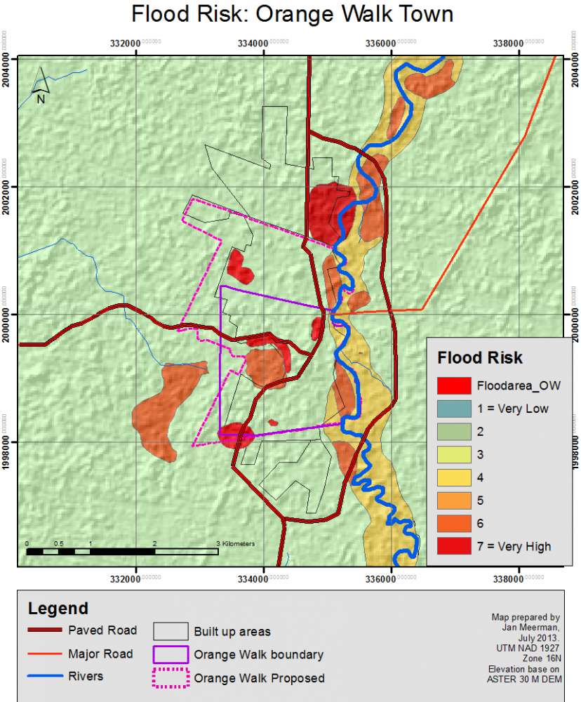
Figure 3. Flood Risk Map showing areas of graduated risk
Soil Map
A soil map is required to indicate the types of soils existing in the area so that permeability to water, strength, and drainage capacity can be assessed. These characteristics can be used by the engineer to determine whether there is a potential for landslides and floods. Soil and drainage engineers use this information to calculate specifications for building in an area. Chapter 8.3 National Scale Landslide Susceptibility Assessment indicates how soil data is a part of the requirements for mapping landslide susceptibility.
It is recommended that soils maps be updated for each country, where they do not exist. These should fully incorporate comprehensive and current data from field investigations in their construction. Development control planners would then be able to refer to them and determine applications by comparing building application submissions with the data on the maps particularly where alternative suggestions may be required. These soil maps should be accessible to all. Applicants should be able to access these data prior to planning their building designs. This assessment can only occur if there are guidelines that specifically state that particular soils at certain slopes will not be approved for development.
In the absence of soil maps, the applicant must arrange for soil testing and submit the results. This data should be maintained to build over time a spatial database of location and quality of different soil types. The soils data is passed to the engineers in the planning committee to determine whether the load bearing capacity of the soil will be compromised by the weight and design of the building.
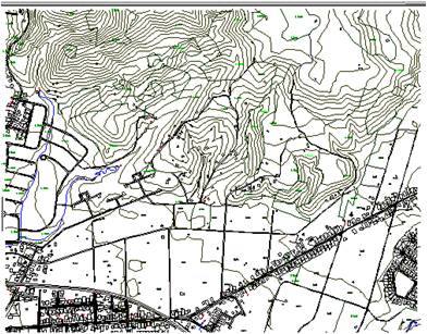
Topographic Map
The topographic map shows the height variations at a large scale so that the exact location of the proposed subdivision can be determined and that the height and slope and the risk of land slippage can be further investigated. If it is apparent from the contours of the topographic map that the elevations are great and that there are steep slopes then the height of the area and the gradient of these slopes can be compared with the approved values. Figure 4 shows both a topographic map that gives precise heights through contour lines of specific value and a location image that can also identify the location of the proposed subdivision with respect to surrounding development and topography.
 |
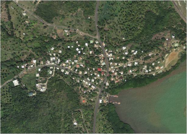 |
Figure 4. Topographic map and location image that give an idea of slopes and heights
Minimum Building Specifications/ Building Codes
Minimum building specifications or building codes should indicate the size, types, and strengths of materials and construction methods that have been calculated to support the maximum loading anticipated for the type of structure. These should be determined by engineers and take into account the history of natural hazard incidents and predictions for weather patterns into the future along with other complex data. Figures 5, 6, and 7 show details for construction that would mitigate impacts of landslides and floods as specified in the OECS building codes and the OECS building guidelines. Figure 5 shows the required construction of soakaways in areas of high water table so that flooding would not result in health hazard. Figure 7 indicates how small houses may be constructed on slopes to resist landslides and to be out of the way of floods. See Use Case 3.3.1. Landslide mitigation methods for building and Use Case 3.3.2. Flood mitigation measures for buildings for more technical details of mitigation measures that can be applied.
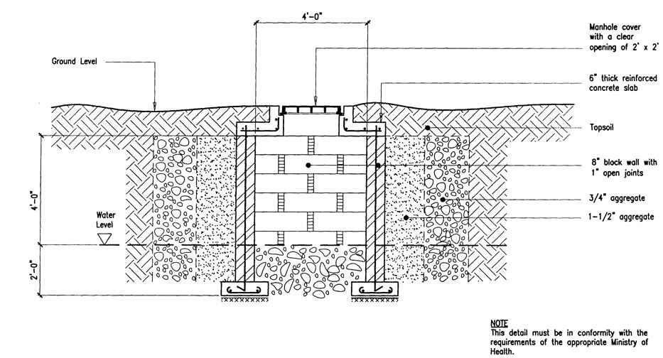
Figure 5. Building specifications for mitigation of risks of flooding and landslide
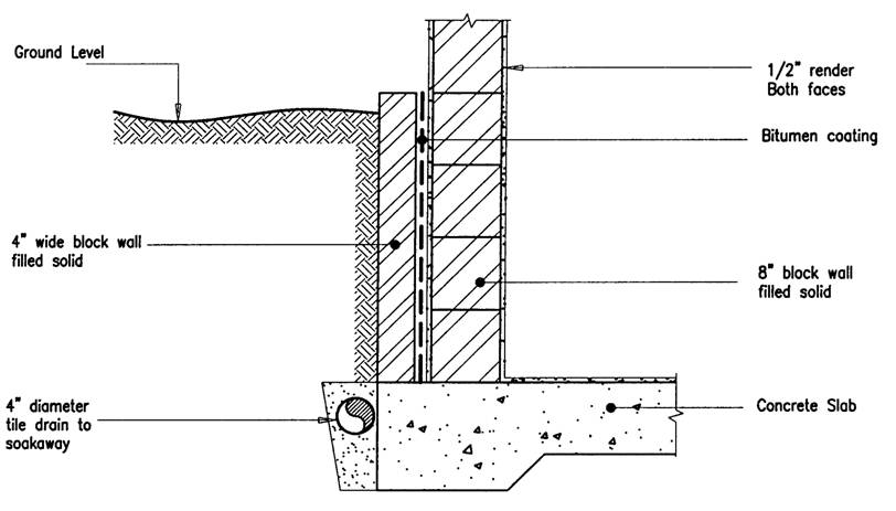
Figure 6. Building specifications for mitigation of risks of flooding and landslide
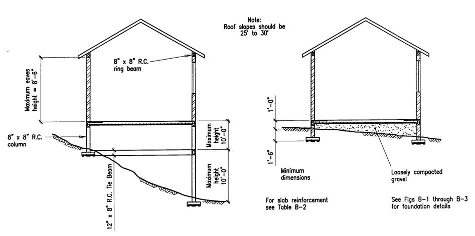
Figure 7. Building specifications for mitigation of risks of flooding and landslide
These building specifications are prepared by engineers and planners can check for absolute conformity of the proposal plans with the specifications or pass the proposal plans to engineers for their assessment. See the Methodology Book Chapter 8.4 on the design of structural mitigation measures to protect critical infrastructure in dangerous locations for information on how these building mitigation measures are developed by structural engineers.
Proposed Building Plan
The proposed building plan needs to contain sufficient detail that will allow for assessment of its conformity with the guidelines. Therefore the floor plan must indicate the dimensions of the building and the individual rooms. The materials to be used in the construction must also be indicated so that it can be assessed whether the building will have adequate strength to withstand hazard impacts. Elevations and sections also have to be shown so that constituent materials and the construction method can be easily seen. Figure 8 shows an example of a site layout and building plan.
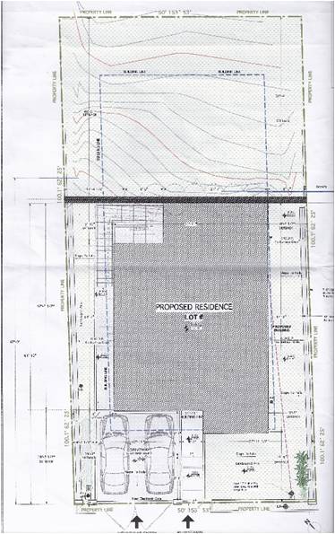
Figure 8. Proposed site layout
Analysis steps:
General Application
Step 1
Assess the application for completeness.
Required data that will allow the application to be processed include:
- The name of the applicant so that communication can be maintained
- Whether the applicant is the owner of the land, a developer, or an agent of the owner so that discussions on modifications to the plan, if necessary, can be targeted.
- Whether the application is done with the owner(s) knowledge and permission, to ensure that the application is legal
- A location plan preferably copied from the state's mapping so that site visits can be made or comparisons can be made with physical development plans
- A parcel plan showing dimensions of the parcel to be subdivided, preferably obtained from registered plans contained in the state's repository, again so that the application is known to be legal
- Information of ownership of the parcel, preferably a recent copy obtained from the state's information databases on ownership to confirm that the application is legal
- A site plan so that site visits can be made or comparisons can be made with physical development plans
- Building plans for details of the proposed construction.
- It is recommended that applicants also indicate if and how landslide and flooding risks were incorporated in the proposal. Did the engineer who prepared the plans incorporate the specifications of the building code? Where there is no building code, did the engineer perform computations to allow for known hazards of landslide and flood?
- Location plan drawn to a scale of 1:25000 for towns and 1:500 for villages and rural areas as this is required for locating the proposed building site. It is easier to locate the site in the urban area as addresses and street names are more formalised.
- Site plan showing:
- Proposed drainage so that adequacy or conformity to specification can be determined
- Boundaries, area and principal dimensions of the land to determine conformity to requirements
- At least one boundary connected to the trigonometrical control station or to identifiable points on the national map sheets so that site visits can be made or comparisons can be made with physical development plans
- The dimensions and area of each proposed subdivided lot
- The location of the proposed building
- The use to which each lot is to be put
- Building plan:
- Conceptual drawing including
- Floor plan to show:
- Room sizes
- Materials used in construction
- Elevations and sections
- Floor plan to show:
- Conceptual drawing including
- Contour lines to determine slope steepness.
- Proposed location of buildings and their various uses to determine acceptable use;
- Any existing buildings on the site and indicate which ones are to be demolished and those to be retained;
- Distance between buildings and their setbacks from roads and footpaths;
- Proposed network of road and footpath and their width;
- Other land uses proposed for the development;
- Landscaping plan, indicating existing trees to be preserved or new areas to be planted;
- Slope stabilization measures;
- Parking areas;
- Proposed Water Reticulation Plan prepared by a qualified engineer;
- Proposed Electricity Distribution Plan;
- Proposed Garbage Disposal System;
- Names of adjoining property owners;
- North point;
- Access to site;
- Any other relevant information/specifications.
The application is assessed to ensure that it contains all of the details of the development requested. This is accompanied by a location plan that indicates where in the country the desired development is located. The application is reviewed to ensure that all the documents and information required are present in the application, depending on the type of application, in this case, the application for final approval for building on land. The application is registered when the requisite fees are paid. Information on the owner and on the proposal is required to link the application to records of previous and subsequent application. Detailed information on the proposal is required to compare with the building code requirements for consistency.
If the application has all the requisite documentation and information, the process can continue. If not the application is returned to the applicant for completion or addition of more information.
Step 2
Assess for Appropriate Land Use - The application is then sent to the officer responsible for the particular area, in which the building construction is proposed, for review. This review can determine whether provisional approval can be given based on whether the land use of building construction is allowable at the location described or whether the proposed land use is allowable but the specifications of the building provided may or may not be allowable.
It is at this point that the proposed building location is assessed against the national, regional, and local area plans. In the absence of this hierarchy of plans, it is recommended that a series of plans be drawn up for each country. This series should include national, regional and local area plans. These should fully incorporate comprehensive and current landslide and flooding risk information in their construction. Development control planners would then be able to refer to them and determine applications by comparing building application locations with the approved uses indicated on the plan. These maps should be accessible to all so that they may develop their applications appropriately.
The Planning Office reviews the application and makes recommendation to the Planning Authority to consider the application. If the application is refused, there should be an appeals process where the applicant can appeal to the Minister. The Minister should be able to set up an appeal tribunal to hear the appeal. The tribunal can approve or refuse but the Minister has the final say. The Minister, however, should not be able to overturn a decision based on the objective majority opinions of the professional group of persons who make up the Planning Authority. The Government, however, should retain an authority to make policy changes based on the number and types of appeals that are presented.
If the land use is not acceptable then the application is returned to the applicant for discussion of use types allowable in the area. If the land use type is acceptable then the application can continue.
Step 3
This is an appropriate time in the process for hazard and risk information on flooding and landslides to be incorporated. The location of the building can be plotted against the local area plan which should have been prepared taking the hazards of landslides and floods into consideration. The location of the building can also be compared with hazard maps or more appropriately landslide and flood risk maps, where they exist.
If the requested building falls in an area that is not hazardous for flooding and landslides the building application can pass this test but continue to be reviewed for other criteria required for the approval. If the requested building falls in an area either noted on the landslide or flood risk maps as being very hazardous or if the area is known by the planning authority to be a very hazardous area for flooding and landslides, the approval can be denied before any further expenditure is undertaken by the proposer. If the requested building falls in an area that is either mapped or known to be moderately hazardous for flooding and landslides, the approval can be approved in principle with specific conditions that need to be addressed or included in the subsequent application for final approval. The engineer who designed the building can be called in to discuss the appropriate mitigation measures with the engineers in the planning authority.
Step 4
Assess for Drainage - The existing drainage network should be assessed against the current prevalence of landslides and floods in the area. The proposed drainage network is examined against the specification to ensure that it meets the requirements as designed by engineers. Minimum requirements would be that the proposed plan includes drains of household size, as defined in the building code, that connect the outfall from the proposed building to the local network. The drainage should have been prepared by a drainage engineer and should include information on flood frequency in the area, and how the increase in impervious surface will affect the runoff.
Step 5
A site visit is made to physically observe the environment within which the building is to be located. Any information that is not discernible from the copies of documents from the state repositories must be noted. This can include approved and informal structures currently existing in the vicinity of the application and the age and integrity of these buildings. Any evidence of recent flooding or landslides should be captured. Discussions should be held with neighbors, the community for information on recent hazard occurrences.
Step 6
All the information gathered should be reviewed by all the authorities responsible for impacts of building on infrastructure, utilities and the environment. Each agency has its own specifications that must be abided by prior to receiving permission to build. Other agencies may wish to visit the site as well to assess for their own requirements. The planning authority that reviews all applications should comprise of representatives of the state agencies for water, sewerage, environmental management, housing, land management, physical planning, health, transportation, and disaster management as these are all areas that are impacted by or impact on building development in the country.
Step 7
If the building specifications satisfy the requirements of the planning authority and all the other impacted authorities, the development is approved in principle. If the application does not satisfy the requirements, typically the applicant is invited to come in and discuss ways in which the request can be modified to conform more closely to what is required so that it can be approved in principle.
If the building development has already been approved in principle or if the application is for final approval, the procedure is similar but more thorough as sufficient details should be provided for approval and monitoring of building construction.
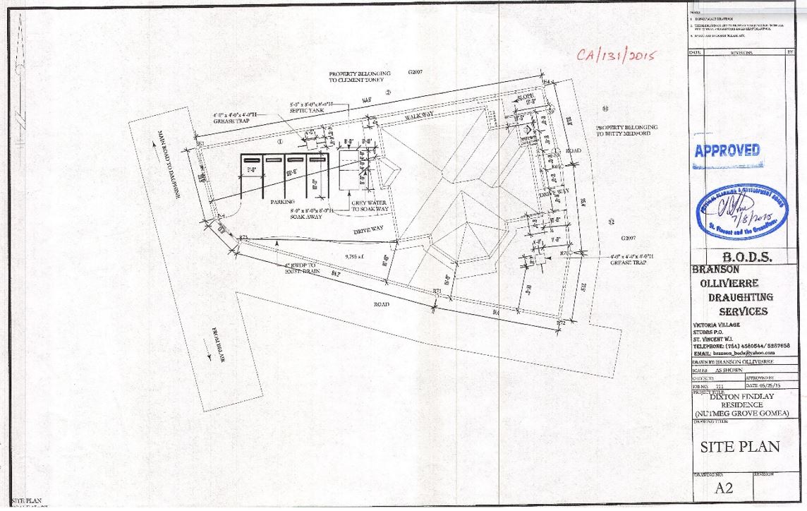
Figure 9. Approved site plan
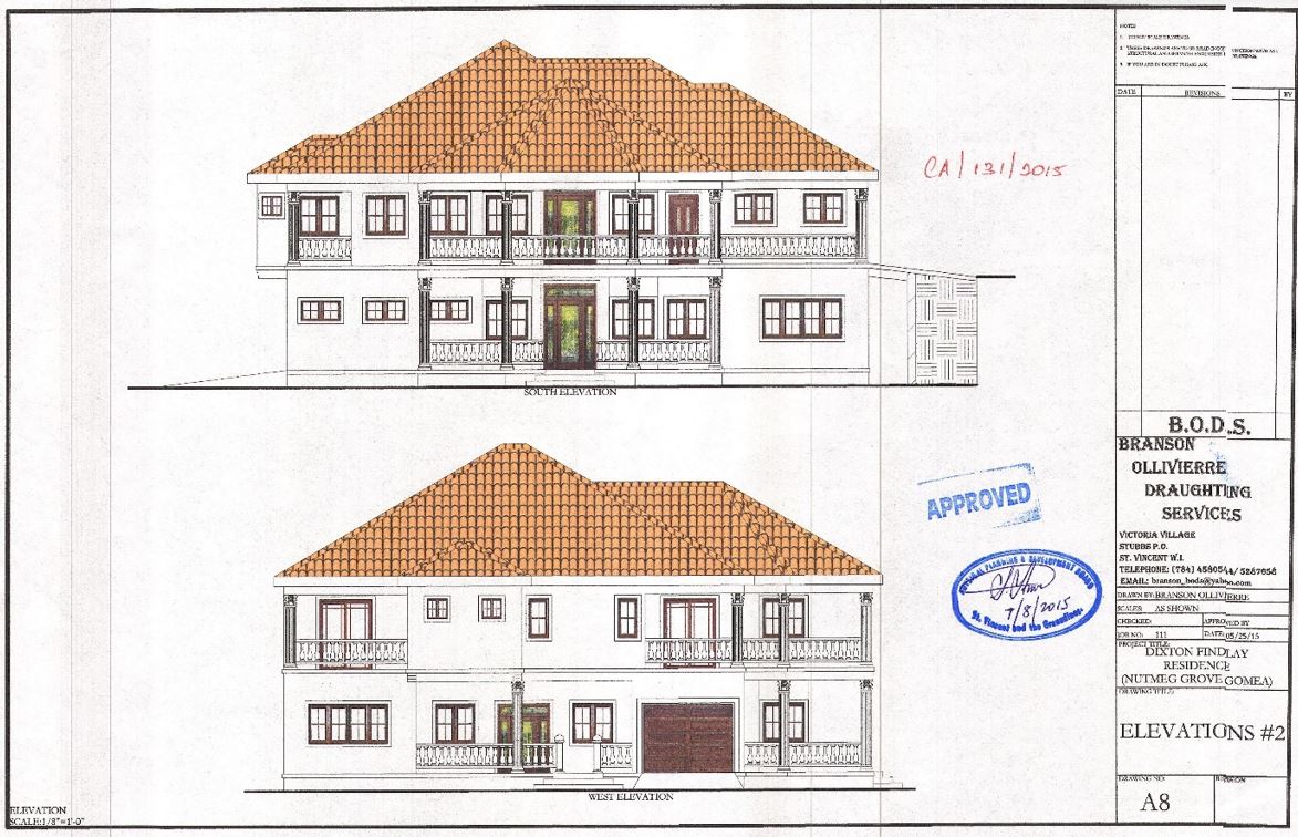
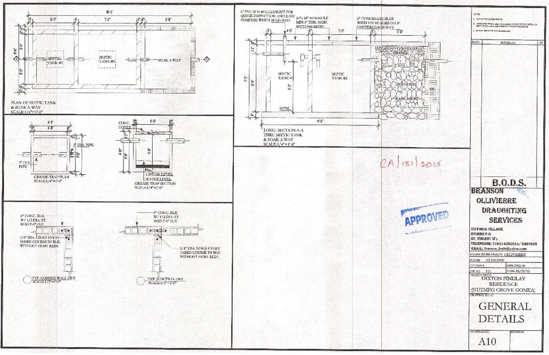
Figure 10. Approved details of building plan
Results:
If the building falls outside of risk zones and within zones designated for the use requested, then the application meets that requirement. In addition, if building specifications follow the building code for buildings that can withstand the risk of flooding and landslides then the application also meets the requirement. The proposal for building is therefore approved in that situation.
If the building falls within high risk zones then the application is refused.
If the building falls within medium risk zones and within zones designated for the use requested, and mitigation measures have been proposed, then the application is reviewed. If, in addition, the building specifications are adjusted beyond the building code for buildings to withstand increased risk of flooding and landslides then the application also meets the requirement. The proposal for building is therefore approved also in this situation.
Conclusions:
The assessment process for an application for construction of a small residential building can be a simple process if sufficient data exists to provide structure to the evaluation. If data on past landslides and floods up to the most recent events have been incorporated into risk maps and other complex factors, and provided for in local area plans then the application can be compared with the range of acceptable uses and specifications. If building design specifications have already been documented based on known soil and slope conditions then the building plans for the proposed construction can be compared with these specifications. If the location and specifications fall within the regulations then the building can be approved.
It would be difficult to assess the proposal for locating the building if the data on previous landslides and floods are not at a large enough scale, are not up to date, do not go sufficiently far back or predict far enough forward into the future, and have not been incorporated into a risk map with equally precise topographic data. Similarly, it is difficult to assess the proposal for building design if engineering specifications have not been drawn up and modified based on previous design failures and success and precise data on geology and soil conditions.
Last update: 31 - 05 - 2016