

By: Mark Trigg
Introduction
In the last two decades, the Caribbean region has suffered over 5 billion US$ losses from natural disasters (EM-DAT). Lying in the path of Atlantic hurricanes means that the small island states and countries of the Caribbean are exposed to high intensity rainfall and extreme winds. Combining these conditions with the steep terrain and low lying coastal areas, makes them extremely susceptible to storm surges, floods and landslides. Providing early warning of these extreme conditions allows appropriate actions to be taken to mitigate some of the potential damage and loss of life. This is particularly important for populated areas close to sources of hazard such as rivers and coast. Early Warning Systems (EWS) are designed to provide this early warning to people with as much lead time and certainty as is possible, in order to allow individuals and communities threatened by hazards to act in time and in an appropriate manner to reduce the possibility of injury, loss of life, damage to property and livelihoods.
Components of an Early Warning System
In 2006, the United Nations released its Global Survey of Early Warning Systems which identified four elements in natural hazard early warning systems:
- Risk Knowledge; the systematic assessment of hazards and vulnerabilities, and mapping of their patterns and trends.
- Monitoring & Warning Service; accurate and timely forecasting of hazards using reliable, scientific methods and technologies.
- Dissemination & Communication; clear and timely distribution of warnings to all those at risk.
- Response Capability; National and local capacities and knowledge to act correctly when warnings are communicated.
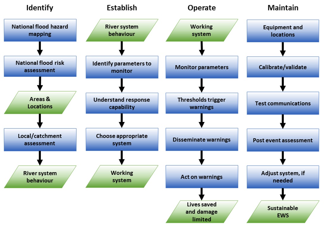
The process diagram below shows how these components are used in the setup and operation of an EWS. These are divided into four simple stages for clarity and described in the appropriate section below. It should be noted that some of these stages may occur in parallel, and they are not necessarily sequential. For more detail on the components described here, the reader is referred to the external resource links at the end of the chapter. We concentrate on flood warning systems in this section, but many of the principles apply equally to other hazards. Use case 5.1 shows how you might go about applying this methodology to examples in the Caribbean (See Use Case 5.1 Design of a local Early Warning system for flooding).
Figure 1: Schematic representation of the components of an Early Warning System
Identify need for EWS
The first step in designing an early warning system is to identify if and where, there is a need for one. This is an important stage of the process because a full assessment of risk is required even if there seems to be an obvious need in response to a recent event. A different event may occur in the future, affecting more/different areas and potentially be even more catastrophic, so it is better to look at overall hazard, exposure and risk in the area of interest in order to assess the need for a system.
National hazard and risk assessment
If there are existing data on flood hazards, for example the national mapping undertaken for this project (see the hazard maps by visiting the GeoCRIS platform and selecting the Maps or Countries tab), this can be used as an ideal starting point. If these data are not available, then a hazard assessment at this level should ideally be undertaken before proceeding. For further details on this see Methodology section 3 - flood hazards and use cases 8.6. The national hazard map will show general areas where there is a high probability of the hazard occurring (rather than just recent historical events). This can be used in a national flood risk assessment, which takes into account infrastructure, property and human exposure to these hazards and quantifies the severity (See Methodology section 5 and Use Case 6.1 and 6.2). The outcomes from this risk assessment can then be used to objectively identify where an early warning system(s) will bring the most benefit in terms of reduction of possibility of flood impact. Most usually these will be populated areas near river systems, but depending on the objectives of the EWS, may also include industrial and agricultural areas of high importance or road/rail networks where an event might cause severe interruption.
Location/catchment assessment
Once the locations of greatest need have been established, then it is necessary to look in more detail at the location specific context of the chosen areas. This means establishing how the hazard is most likely to occur and what its characteristics are. This will allow an appropriate EWS to be established. The location specific context is established through a catchment or location assessment. Undertaking this assessment is a skilled technical role and requires a good understanding of meteorological, hydrological and hydraulic processes in order to understand thoroughly how the river systems work and the detailed mechanisms that occur during a hazard event. It should be noted here that although there may be similarities between catchments, local conditions and characteristics often make flood hazard a particularly local phenomenon, which means this level of assessment is essential otherwise there is a risk that the EWS will be implemented poorly, perhaps warning the wrong people/areas or setting inappropriate warning thresholds.
This local assessment should cover hazard events from start to finish, beginning with climate and weather conditions that give rise to the events (e.g. high intensity rainfall from tropical storms), what catchment conditions and characteristics give rise to particularly dangerous river conditions (e.g. steep slopes and impervious soils in the upper catchment), and finally how the high river levels translate to out-of-bank flows and the consequential flood flow paths through populated areas. Understandably this level of assessment requires a reasonably large amount of geophysical and exposure data of an appropriately fine resolution, some of which may be available already, but it is likely that some specific local surveys may be required to collect suitable data (e.g. details of population and buildings at risk in floodplain areas - so you know who to warn). The reader is referred to the data management book for further details (See Data Management Book 2.2, 2.4, 4.4). It is likely that catchment or fluvial (river) computer modeling will be undertaken as part of the local assessment to establish catchment and flood behaviors (See methodology book 3.3 flash flood modeling and 3.4 fluvial modeling). A critical component of this local assessment will be in the form of local knowledge, making up for data limitations and feeding in stakeholders first-hand experience of what happens in an event. The technical specialist often collects this through a catchment walk-through and interviews with stakeholders.
The outcomes of the local assessment will form the basis for the design and implementation of the EWS. It should identify:
- What conditions give rise to an event. There may be more than one mechanism that gives rise to risk. This will make it clear what should be monitored in order to get an early indication that an event is imminent.
- What explicit parameters to monitor, where to measure them, and how frequently to measure them.
- The physical flow paths and timings of events, possibly with intensity (e.g. depths and velocities). This will make it clear who will need warning and how quickly. The understanding of the timing is crucial for an EWS. Smaller steeper catchments typical of the Caribbean islands and southern part of Belize will respond to rainfall within an hour or so, whereas large river systems such as Belize River may take from multiple hours to days to respond (See Use Case 5.1 Design of a local Early Warning system for flooding).
Establish and operate system
Monitoring parameters and thresholds
Once an understanding of the river system and what is likely to occur in an event has been ascertained, then it is possible to design and build an appropriate system. It should be clear from this knowledge, which specific locations will be best for monitoring relevant parameters, for example rainfall higher up in the catchment, upstream and local water levels and so on. Measuring rainfall & river levels form the core monitoring system for an EWS. Measurement methods can vary considerably in sophistication. Measurements can be made using simple rain gauges and/or graduated staffs in the river monitored by volunteers, through to fully automated and telemetered systems that measure and transmit data automatically to a monitoring center. The choice of what method to choose is not solely based on what is affordable, but more on how effective the method will be and what auxiliary technical support there is now and will be available in the future. While complex automated systems may seem an ideal solution, they can be challenging to maintain and can limit contribution and involvement of the relevant communities, therefore limiting sustainability of the EWS. It is generally better to use a measurement method which involves closer involvement of the community, which improves engagement and in the long run ensures a sense of ownership for the very people that the system is designed to warn.
Dissemination and action
Typically for an EWS, when monitored parameters exceed predetermined thresholds (determined from local assessment described above) this triggers the next stage of the system, which involves informing someone that this has occurred and putting into action the predetermined plan of disseminating warnings and acting on those warnings. The responsible parties for each of these stages can vary depending upon local capabilities and legal responsibilities. If there is a strong and well supported institutional capability, the monitoring and dissemination may be undertaken by local government institutions. However, sometimes, for similar reasons to community monitoring of parameters, it may be better to involve local communities in this role, particularly if the community already has a strong collective sense of responsibility. How messages and warnings will be practically disseminated is of critical importance and should be studied in detail, including having backup alternative forms of communication in case the primary system fails. As well as physical systems in place to monitor, and communicate warnings, it is also important that a clear procedure is established so that responsible parties understand what they need to do at each stage of an event. These procedures should be documented in a clear, easy to understand way, and need to be easily available, ideally posted in clear view, i.e. not in a report on a shelf.
It is common for an EWS to be established that uses several levels of increasingly urgent warnings, with each level increasing the urgency and escalating the warning to more people to take further actions. This multi-tiered approach is sometimes referred to as the "Ready, Set, Go" concept which conveys the severity and timing of a forecast hazard and the level of forecaster confidence. This is typically to allow for the fact that an EWS is most effective if warnings are given as early as possible, but offset by the fact that very early warnings can be unreliable due to uncertainties of an event actually happening. False warnings can have a very counterproductive effect in that too many will lead communities to ignore future warnings with potentially disastrous consequences. An example of a staged approach would be an early warning of impending high rainfall from the meteorological services being communicated by text or phone to designated volunteers who are put on alert of a possible event. The volunteers can then monitor the rainfall and/or river levels until the weather system triggers a threshold or passes by without consequences.
The final stage in the warning process is action based on the warnings. This can include individual responsibilities to prepare or evacuate, but also involves persons who ensure action is taking place and further reinforces the message for people who may not have received the initial warnings. This can involve responsible officials and/or community members.
Maintain system
An extremely important part of the design of an EWS is to consider the long term sustainability of the system. It is surprisingly common for well-designed and expensive systems to fail due to a lack of basic maintenance, for example. Events requiring warnings may be infrequent enough that equipment can fail unnoticed until an event occurs and then it is too late. Long term funds and procedures need to be provided so that regular checks on equipment are conducted and any deficiencies repaired. For remote gauges, this can involve field vehicles and fuel costs as well as staff time and replacement equipment. The simpler the system is, the less expensive this process is, but this will not negate the need for regular checks. Automatic equipment will also require calibration and checks to ensure it is reporting correct values. Primary and backup communications systems will need to be checked to ensure they will operate correctly during an event.
Another useful aspect of maintaining a system is to carry out a post-event assessment to see if the EWS can be improved. For example by adjusting warning thresholds, or increasing the warning area to cover people at risk that the initial location assessment failed to identify but were exposed to risk in a real event.
Examples of existing Caribbean systems
Central American Flash Flood Guidance (CAFFG) System
This system is currently operational for each of the seven countries in the Central America region: Panama, Costa Rica, Nicaragua, El Salvador, Honduras, Guatemala, and Belize. CAFFG, the first fully automated real-time regional flash flood guidance system, has been in operation for seven countries in Central America since 2004. The core FFG system software was designed by the Hydrologic Research Center (HRC) through their research activities. The CAFFG system is an implementation of the FFG software by HRC in collaboration with NWS and funding by the U.S. Agency for International Development/Office of U.S. Foreign Disaster Assistance (USAID/OFDA).
Overview of the system is available in Chapter 5 of NOAA FFEWS guidelines, 2010 or visit the Live CAFFG System.
Community operated systems with simple equipment
Early warning started in the 1990s, but is only in operation in Jamaica and Trinidad and Tobago. A community based flood warning system was set up in Rio Cobre and Rio Grande, Jamaica and is maintained by the Water Resources Authority in Kingston. Updates on the systems are available at the following links, showing the challenges of maintaining an EWS:
- For 2004-2005, an update of the systems is on page 24
- For 2010-2011, an update of the systems is on pages 72
Automated centralized system
Designed for the Caparo River, Trinidad as an early warning system pilot project, using Delft-FEWS software (Deltares). Description of system on pages 37-52.
Caribbean Disaster Management Project (CADM, 2002-2005), (CADM2, 2009-2012)
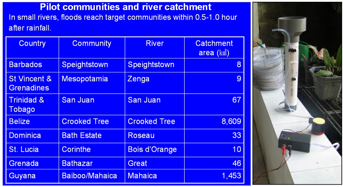
CDEMA and Japan International Cooperation Agency cooperated in the CADM project, a capacity development project of which early warning was a part. Figure 2 shows the catchments in which EWS were established, based on a community based warning system. Community based systems are cheap, easy to operate and maintain, and are based on local residences and local alarms that sound.
Figure 2: Catchments in which Early Warning Systems were established. Participating communities and catchments in the CADM project (phase I). The photo on the right shows a cheap local rain gauge directly connected to an alarm. The threshold is in the form of local experience, in this case 25 mm in a few hours
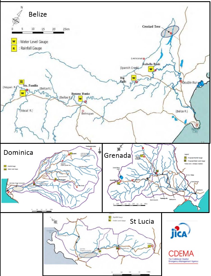
- Dominica: The upper catchment area of the Roseau River was also affected by the 2013 floods. Although the city wasn"™t flooded, several buildings in the upper area were, due to the under design of the bridges. An Early Warning System was installed but was not functioning due to lack of maintenance. Later on it was washed away by Tropical Storm Erika in 2015. See Figure 3.
- Saint Lucia: a Flood Early Warning System (FEWS) was installed for Gros Islet, Corinthe, which has been developed together with JICA and CDEMA during CADM2 and includes rainfall and waterlevel gauges.
- Saint Vincent: a flood Early Warning System was installed for Zenga River in Mesopotamia. It is not clear whether this system is till functioning.
- Grenada: A flood early warning system has been installed on the Great River with river height measurements using laser and a threshold that sets off SMS alerts. The system is still working but experiencing data logging and transmission issues. See Figure 3.
The CADM Phase 2, Final report of June 2012 can be downloaded here. An update (December 2015) of these three systems is available here
Figure 3: Early Warning Systems with location of watersheds, rain gauges and water level gauges in Belize, Dominica, Grenada and Saint Lucia within the CADM project.
Resources and links
UN 2006. "Global Survey of Early Warning Systems, An assessment of capacities, gaps and opportunities towards building a comprehensive global early warning system for all natural hazards." Final Version. A report prepared at the request of the Secretary-General of the United Nations. [http://www.unisdr.org/2006/ppew/info-resources/ewc3/Global-Survey-of-Early-Warning-Systems.pdf]
An excellent and very comprehensive guide is provided by NOAA. NOAA FFEWS guidelines 2010. [https://www.meted.ucar.edu/communities/hazwarnsys/haz_fflood.php] or [http://www.meted.ucar.edu/communities/hazwarnsys/ffewsrg/FF_EWS.pdf]
Relevant in-depth information on early warning systems in Caribbean:
Examples of effective EW systems with community involvement:
- Report on Early Warning Systems in the Caribbean Sub Region, University of the West Indies at Mona, Jamaica. Caribbean Disaster Information Network (CARDIN), Thompson, Stacey (2003).
- CDEMA, 2010. FINAL Report Training Workshop on Multi-Hazard Early Warning Systems with focus on Institutional Partnership and Coordination, Costa Rica. March 22-25, 2010.
- Oi, H. 2011. JICA's initiative for Hydromet Modernization and effective early warning systems in Developing Countries. World Bank Distance Learning. Powerpoint presentation.
Last update: 19-07-2016