

Useful documents on Land use planning
 Land Use Planning, Concepts and Tools. GIZ.
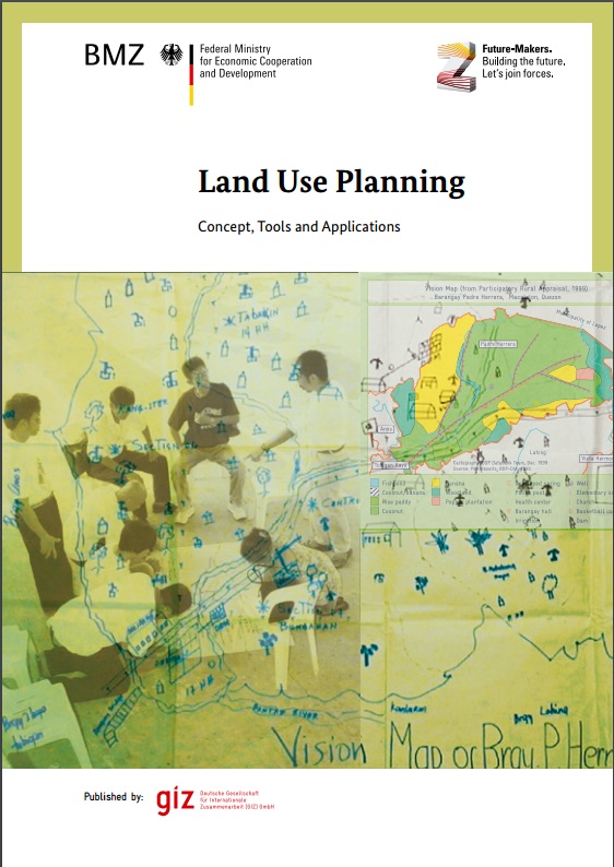
The GIZ manual on Land Use Planning, Concepts and tools has been prepared by an interdisciplinary group of experts with land use planning experiences in Africa, Asia, Europe and Latin America. The land use planning discussion coming from new fields where land use planning nowadays is applied. The guide is based on a previous publication from 1995 and enriched with many recent examples of land use planning in a much broader context than in the past. It also includes technologies that have not been available at that time or only in a limited way. Based on a preparatory study in 2008, an experts meeting in 2009 defined targets, contents and structure of the publication. More than 50 experts contributed to the preparation of the present manual.
Natural and Technological Hazards and Risk Affecting the spatial Development of European Regions. EU-ESPON project.
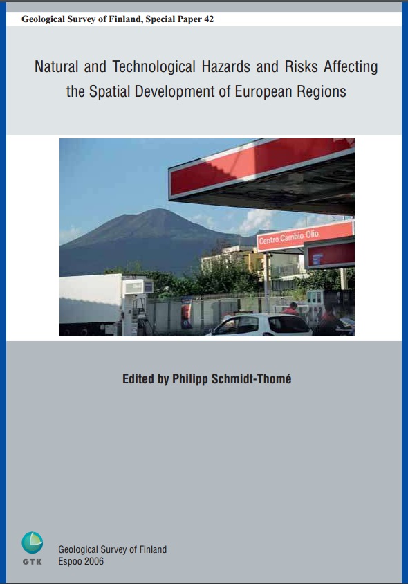
Natural and technological hazards influence spatial development.Displaying spatial patterns of natural and technological hazards on a regional level, including possible impacts of climate change on hydro-meteorological hazards, delineates potential obstacles and challenges to future spatial development. The European Spatial Planning Observation Network (ESPON) requested spatial patterns and territorial trends of hazards and risks covering the European Union, its accession and associated countries. The approach presented here uses results of international hazard research, harmonizing and combining those with an own methodology to display comparable information over the entire project.
 Planning Safer communities. Land Use Planning for Natural Hazards. Emergency Management Australia.
Implementation of land use policies at the local level is most effective when there is cooperation and collaboration between all levels and sectors of government, an integrated approach to decision making and a transparent partnership between government, the community and the private sector. 'The whole is greater than the sum of the parts' - by integrating community desires and needs, and by working together to balance interests, Australians can achieve the goal of sustainable economic and environmental development and create safer, sustainable communities.
 Land use planning for Climate change adaptation in Small Island Caribbean States. Danielle Edwards.
This paper identifies five key areas in which climate change adaptation strategies are urgently required. First, this paper discusses the importance of land use planning in relation to climate change adaptation. Secondly, this article analyzes land use planning legislation in Dominica, Barbados and Trinidad & Tobago and evaluates whether these laws can be used to support development and implementation of adaptation strategies in four areas: watershed management, food security, disaster management and sustainable tourism development. The fifth adaptation strategy, protecting indigenous people, is discussed only in relation to Dominica
 OAS: Primer on Natural Hazard Management in integrated Regional Development Planning
This Primer has been prepared as reference document for practitioners in the field, to guide integrated development planning teams in Latin America and the Caribbean in the use of natural hazard information during the different stages of the planning process. The Primer is divided into three parts, each covering a specific subject area and complementary to the others. Each part, with the chapters contained therein, is meant to provide the planning team sufficient guidance in that subject area for it to proceed with the task at hand. There is extensive cross referencing between chapters. Since the book is intended for reference, each chapter is complete within itself (even though this results in some redundancy), with its own detailed table of contents, a short summary, a statement of its objective, and complete references.
Summary and conclusions
The tables below gives a summary of the contribution of spatial planning to risk management (from Greiving & Fleischhauer 2006
|
Risk Management strategy |
|
|
|
|---|---|---|---|
|
E.g. planning settlement and transport structures that cause less greenhouse gas emissions |
Supporting the use of regenerative energy |
Strategies for reducing greenhouse gas emissions (e.g. transport structures) |
|
Maintenance of protective features of the natural environment that absorb or reduce hazard impacts (retention areas, sand dunes) |
Local rain-water infiltration |
Flood protection plan, coastal protection plans, reforestation, adapted land cultivation |
|
Designations in regional plans like flood hazard areas |
Zoning instruments |
Adequate allocation of threatened infrastructure |
|
Secure the availability of space for protective infrastructure |
Preventive measures as a part of building permissions |
Engineering design, protective infrastructure (shoreline dams) |
|
- |
Rebuilding planning |
Emergency plans (e.g. SEVESO II safety reports) |
|
|
1. Co-ordinated zoning in general land use plan |
2. Specific hazard zones map in general land use plan with direct binding character |
3. Independent map without a direct binding character to landowners |
|
Description |
Consideration of the hazard areas during the compiling or the review of the local land use plan by the suitable allocation of types of land use and intensity. |
The hazard zones are displayed as a separate map, which has a direct effect on land ownership rights. (Hazard zones determine for the allowed land use). |
Definition of hazard zones within the scope of expert planning ("hazard zone plan") - objections may be raised to decisions that are made on the basis. (Hazard zones are meant as notification; no binding character) |
|
Advantage |
At the local level, no new instruments are necessary. |
The hazard can be considered in a uniform manner for the complete local planning area. The definitions of the hazard zones can be applied directly in building approval procedures. |
A simple alteration of a hazard zone plan is possible. Restrictions can be made according to the latest information. The administrative expenditure is low. Suitable for a cooperative strategy aiming at influencing existing building structures by means of individual building protection. |
|
Disadvantage |
Plans only contain information about hazard areas when a special reference is made to these. Alteration of the danger situation means that the zone plan must be adapted accordingly. |
An alteration of the danger situation means that the complete zone plan has to be adapted accordingly. For legally binding effects a very carefully and exact mapping is needed. |
No effectiveness in case of an unwillingness of private stakeholders to participate. |
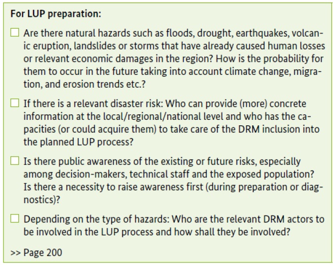
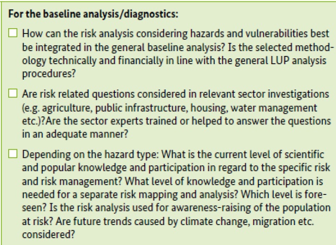
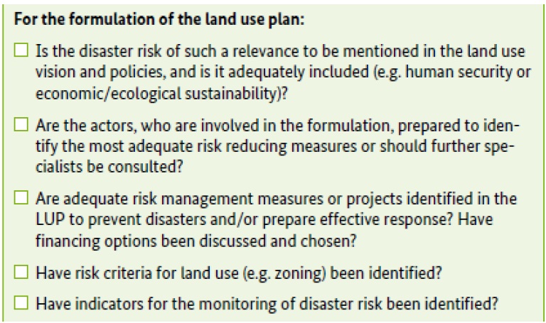
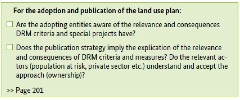
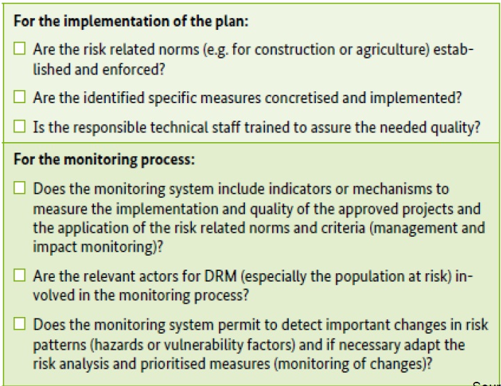
Disaster risk management checklist for land use planning
Conclusions
- Spatial planning has to anticipate the consequences (or chances and risks) of actions from the beginning of a planning process, as part of the planning goal findings
- Risk assessment and management should be incorporated within the spatial planning process to achieve greater sustainability and resiliency of society's development
- Planning is responsible mainly for future land-use. Thus, vulnerability related information is less important compared to a given hazard potential.
- Spatial planning is one important actor in risk management, while at the same time several other actors are responsible for the assessment and for certain risk management measures.
- Risk related information is just one type of information, among a number of others types, between which a trade off has to be made.