

Summary
When a parcel of land is being subdivided it can be anticipated that change of ownership and construction or other intensified land use will eventually occur on the subdivided portion as this is often the case. It is therefore necessary to determine whether the eventual construction would cause or increase flooding and landslides on the parcel prior to approving the request for permission to subdivide. This use case provides a summary of the process of assessing an application for subdivision to determine whether the subdivision will create or increase the threat of flooding and landslides. The process allows the planner to determine whether the application should be approved or denied. To illustrate the optimal theoretical approach to application assessment, the ideal application for subdivision permission is described including the points at which flooding and landslide information can be incorporated. The actual procedures for dealing with applications for subdivision, as occurs in the countries of Belize, Dominica, Grenada, Saint Lucia, and St. Vincent and the Grenadines are given as examples.
Keywords:
Land use, planning, subdivision
| Before you start: | Use case Location: | Uses GIS data: | Authors: |
|---|---|---|---|
| Read Methodology Book Chapter 7 | Procedures summarized for Belize, Dominica, St. Lucia, St. Vincent and the Grenadines and Grenada | No | Charisse Griffith-Charles and Jeanna Hyde-Hecker |
Introduction:
The physical planning process involves deciding on what types of development and at which locations will be in the best interest of the country and its inhabitants. Within this framework, the actual development that is implemented should maintain a delicate balance to ensure environmental sustainability while not unduly restricting physical development. Individuals may seek permission to carry out development and these requests should be assessed to ensure that they not only fit within the overall plan for physical development but also fit within the ongoing changes, and impacts taking place in the community as development occurs. Subdivision of parcels is a form of development as construction usually follows subdivision of land. Subdivision of land and subsequent construction can create or increase the risk of landslide and flood as built development can weaken soil by allowing liquid infiltration, and increase runoff volumes by adding to the area of impervious surfaces. The current land use planning process for subdivision approval that occurs in Grenada, Saint Lucia, Dominica and St. Vincent and the Grenadines does or does not sufficiently incorporate hazard and risk information. Belize does incorporate some investigation of hazard and risk as it relates to floods. The following process for review of application for subdivision describes a theoretical process which also includes where data on hazard and risk of flooding and landslides can be incorporated.
Objectives:
The objectives of this use case are to:
- Provide a clear structure of the land subdivision approval process,
- Recommend and indicate where in the process of application for permission to subdivide, landslide and flood hazard information should be included.
- Recommend how to include current hazard and risk before establishing the subdivision
- Recommend how to estimate new or increased hazard and risk that could potentially be caused by the proposed subdivision.
Flowchart:
The following animation gives the flowchart that is used in this use-case for land subdivision process. Click on parts of the flowchart to see more details and explanations
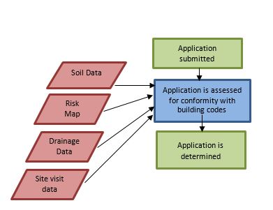
Problems definition and specifications:
An applicant would like to subdivide a parcel into smaller parcels in order to transfer the subdivided parcels to other potential landowners. The applicant requests permission of the planning authority to subdivide the parcel. The physical planner wishes to allow subdivision when it is safe to do so for the community and wishes to refuse or guide the specifications of the subdivision where it will lead to risk for the landowner and/or increase the incidence of landslide and flood and therefore affect the safety of the community. Regarding the inclusion of hazard and risk into the subdivision approval process, Physical Planning needs to be able to show whether an area is prone to flooding and/or landslide or not and the degree to which the area would be affected. As a subdivision would create changes to the site, it is also necessary for the planner to be able to estimate if the changes would create or increase hazard, exposure and vulnerability in the future.
Data requirements:
The list of data required includes:
- National Land Use Plan
- Local Area Land Use Plan
- Flood Hazard
- Flood Risk Map
- Landslide Hazard
- Landslide Risk
- Environmental Impact Assessment (EIA) Report
- Topographic Map
- Proposed Subdivision plan
National land use plan
At the national level there should ideally be a national plan at scales of 1:50,000 that would indicate if subdivision for development is desirable for the particular area for which the application is submitted. Broad areas of residential, agricultural, environmental reserve, and industrial uses can be illustrated at this scale. Figure 1 shows an example of a national plan at a broad scale. See Use Case 2.1. National Land Use Plan which illustrates the process for preparation of a National Land Use Plan. Broad hazard areas or risk restricted areas should be included in this plan but this is too general to be used for specific planning of a subdivision at the parcel level.
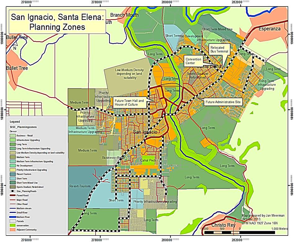
Figure 1: Example of Plan from Belize
Local area plan
Local area plans should be available at larger scales than the national plan. These can be at 1:10,000 and contain information on a settlement or community and how all the necessary amenities are distributed within that area.
Local Area Plans are lowest in the hierarchy of development plans, coming after National Land Use Plans and Regional Land Use Plans. They are, however, prepared at the largest scales of all plans and contain more precise and more copious detail. Local area plans require, for preparation and revision, policy data, built infrastructure data, natural topographic and land cover data, and social demographic data. Hazard information should be incorporated into the creation of these plans and various levels of risk should be indicated. Local area plans should be available to guide the approval of application for subdivision process. Figure 2 shows a local area plan with planning zones. See Use Case 2.2 Local Land Use Planning for more detail on the preparation of local land use plans that take hazards and risk into consideration.
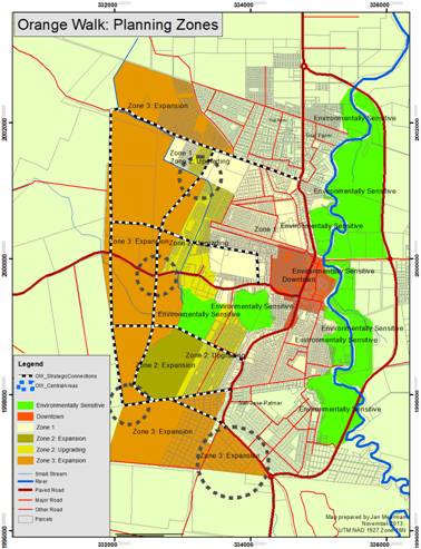
Figure 2: Example of Local Area Plan from Belize showing planning zones
Flood Hazard map
Flood hazard map: includes flood extent, depth and probability of occurrence. For this project they are carried out at the national scale for each of the five countries. The maps should be used to show predominant flood hazard zones and thus which areas to target for further study. They should not be used for planning at the parcel level or for engineering purposes.
Flood risk map
Flood risk maps at a large local scale of 1:10,000 may be necessary to disseminate information on the risk of flooding within a community. Flood risk maps can be produced from analyzing existing hazards and creating a risk model. See Chapter 6.1 Multi Hazard Exposure Analysis on risk assessment for more detail on the construction of risk models as these are complex activities. See Methodology Book Chapter 5 and Use Case Book Chapter 6.3 for a more detailed explanation and procedure for creating a flood risk map .
Landslide Hazard & Risk Maps
A landslide risk map, similar to a flood risk map, displays the likelihood of a landslide occurring at a particular location. If the area applied for falls into a high risk zone on the map, then the application should not be allowed. In medium risk areas, mitigation measures are required, and in low risk areas, subdivision is allowed. Failing the existence of a landslide risk map, reference can be made to a land slide hazard map (See Chapter 4.4 of the Methodology Book for the procedure for preparing a landslide hazard) or a landslide inventory for the location of previous hazard events. See Chapter 9.3 of the Use Case Book for the process for developing a landslide inventory.
Environmental Impact Assessment (EIA) Report
An EIA is conducted to assess the potential impacts of a proposed development on the environment including the society and community and their health. The impacts may be positive or negative and all should be highlighted in the report. It should be inclusive and include the thoughts and opinions on the proposal of those in the community who may be affected. It also provides an opportunity to consider alternatives that have different impacts that may be more acceptable. It allows for easier assessment by the planning authority and also provides a baseline for subsequent assessment of actual impact when the proposal has been implemented. EIA should be both prepared and reviewed by a multi-disciplinary planning team to ensure that all the potential risks are taken into consideration in the granting of the application to subdivide, particularly for large areas of subdivision and dense subdivisions. Ideally, there should be a documented structure and format for the preparation of the EIA report that elaborates on all the required data that should be presented. At least, the EIA should describe in detail the proposed subdivision and subsequent use of the land. It should detail the physical and social conservation ideals affected by the proposal. It should identify the potential effects, both positive and adverse. It should then describe proposed measures to avoid, remedy or mitigate adverse effects. It should also identify any alternative designs that would mitigate the adverse effects of the proposal along with cost/benefit analyses. It should prescribe a possible program to monitor any ongoing effects. It should indicate the specialties of the professionals whose input went into the preparation of the report. For example, a large residential subdivision may require input by drainage and soil engineers, hydrologists and environmentalists.
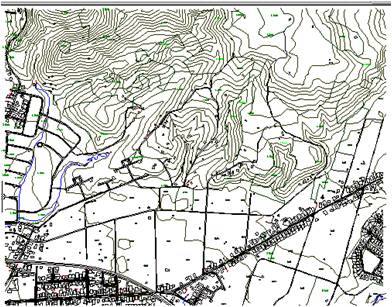
Topographic Map
The topographic map shows the height variations at a large scale so that the exact location of the proposed subdivision can be determined and that the height and slope and the risk of land slippage can be further investigated. If it is apparent from the contours of the topographic map that the elevations are great and that there are steep slopes then the height of the area and the gradient of these slopes can be compared with the approved values. Figure 4 shows both a topographic map that gives precise heights through contour lines of specific value and a location image that can also identify the location of the proposed subdivision with respect to surrounding development and topography.
 |
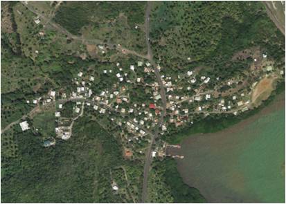 |
Figure 3: Topographic map and location image that give an idea of slopes and heights
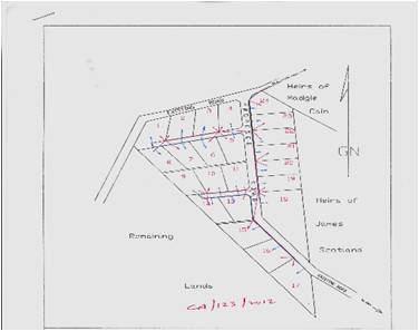
Subdivision Proposal Plan
A subdivision proposal plan, prepared by an authorized professional land surveyor shows the dimensions of the proposed subdivision and the proposed electrical and water distribution and road network. This also indicates the relationship of lots to the slope and elevation. Figure 5 shows examples of proposed layouts of parcels in a subdivision. The areas of the parcels, the slope of each parcel, the access provided and the slope of the access, all need to conform to previously agreed values decided on and documented by the planning authority.
 |
 |
Figure 4: Subdivision proposal plans showing layout of parcels
Analysis steps:
Step 1
The submission is assessed for completeness: The application is accepted if all information is present to allow assessment which includes:
- The name of the applicant
- Whether the applicant is the owner of the land, a developer, an agent of the owner
- Whether the application is done with the owner(s) knowledge and permission
- A location plan
- A parcel plan showing dimensions of the parcel to be subdivided, preferably obtained from registered plans contained in the state's repository
- Information of ownership of the parcel,
- A subdivision plan, prepared by an authorized, professional land surveyor, drawn to scale, showing the dimensions of the proposed subdivision in compliance with the conditions as per instructions contained in the planning authority's documented guidelines
- Details of the type of subdivision and proposed use: residential, commercial, industrial.
The application is reviewed to ensure that all the documents and information required are present, depending on the type of application, in this case, the application for final approval for subdivision of land. This information is required to facilitate the processing of the application. Information on the owner is required to link the application to records of previous and subsequent applications. If an EIA is required for the type of subdivision, it should be submitted at this stage.
Step 2
The application is then sent to the officer responsible for the particular area, in which the subdivision is proposed, for review. This review can determine whether the outline approval can be given based on whether the subdivision is allowable at the location described or whether subdivision is allowable but the specifications of the subdivision provided may or may not be allowable. The application is compared against the National Land Use Map to see if the land use is allowable according to the plan. The application is also compared against the more detailed local area plan, if one exists, to see if the proposed use conforms with the plan for development in the community. In the absence of an approved national physical land use plan, or regional and local plans, documented or previously implemented policies on locations of built development can be referred to for guidance on what type of development is encouraged or accepted. For example, if the proposal is in conformity with existing development, such as residential subdivision close to existing residential subdivision, this type of use can be considered to be acceptable and the application can be further processed. If the proposal is outside of the uses allowable, then the application can be returned to the applicant with some discussions on how to amend the proposal to better conform with the allowable uses.
Step 3
This is an appropriate time in the process for hazard and risk information on flooding and landslides to be incorporated. The application is compared against the existing flood and landslide risk maps for the local area. If the requested subdivision falls in a very hazardous area for flooding and landslides, the approval can be denied before any further expenditure is undertaken by the proposer. If the requested subdivision falls in an area that is moderately hazardous for flooding and landslides, the approval can be conditionally approved for this stage with a specific request to satisfy conditions that need to be addressed before final approval. For example, if the flooding can be minimized or prevented with specific types of drainage networks such as, sustainable urban drainage systems (SUDS) and the landslides reduced or prevented with specific types of constructions such as retaining walls, terracing, stepped drains, or planting of grasses and shrubs then these must be stated as requirements that must be proposed for approval. The application is returned to the applicant for further development of the proposal. The applicant would need to have an engineer design the mitigation structures. SUDS are natural and sustainable drainage networks that seek to reduce the typical impervious surfaces introduced by concrete drainage systems. They also seek to reduce the speed and volume of the water being drained away in storm conditions by trapping the water in shallow ponds that can release the water more slowly back into the system. Retaining walls can shore up fragile slopes while terracing also does so but with less hard construction required. Stepped drains reduce the speed of the water in the drainage system and thus the damage that can be caused. Planting of grasses and shrubs on vulnerable slopes can also reduce the incidence of landslides.
If the requested subdivision falls in an area that is not hazardous for flooding and landslides the subdivision application can pass this test but continue to be reviewed for other criteria required for the final approval. If risk maps do not exist then programs or models that can predict the likelihood of floods and landslides given the prevailing conditions and anticipated hazard impacts can be used. See more details of how this can be done in Chapter 6 on risk assessment (See Use Case in Chapter 6.1 Multi Hazard Exposure Analysis on risk assessment for more detail on the construction of risk models as these are complex activities. See also Chapter 6.3 of the Use Case Book on the procedure for preparation of a flood risk map.
Flood and landslide hazard data should be utilized to determine if the site falls within restrictive flood and landslide hazard zones. Always be aware of the limitations of these types of data. The limitations of the national flood and landslide hazard maps created under this project are described in the Methodology Book 3.3 Flash flood modeling under Important Considerations and in the use cases 8.3 National scale landslide susceptibility assessment, under Recommendations; and, 8.6 for the Belize Flood hazard map, under Limitations. For instance, the flood hazard map for Belize should not be used to definitively determine flood extents at more specific scales than the district level. The purpose of the national map is to indicate where further detailed studies should be carried out and to serve as a guide, along with other information sources, on which areas are likely to flood. Therefore, further studies should be carried out for areas within the districts that are popular for subdivision applications which fall within zones likely to flood.
A risk analysis, which estimates the risk from hazards to people, property or the environment should be carried out. A risk analysis generally contains the following steps: hazard identification, hazard assessment, elements at risk/exposure analysis, vulnerability assessment and risk estimation. For examples on how to apply the data see use case 6.2 National scale exposure analysis for river flooding in low lying areas. The examples are based mainly on hazard and exposure data but not on vulnerability data which were not available.
To fulfill the third objective of this use case, the reader is referred to use case 4.2 Multi-hazard risk assessment for the current situation in order to analyze the current risk before the subdivision takes place. Use case 4.4 Analyzing changes in risk related to possible future scenarios can be applied to objective 4 on learning how to estimate the effect of the potential changes of a subdivision.
Step 4
The EIA report is reviewed to determine whether the negative impacts of subdividing the land is within an acceptable predetermined range. At this stage the EIA report is examined for conformity with stipulated submission requirements. The EIA report should contain the details as stated in the data requirements section of this use case.
If the report contains all the requirements, the application goes forward. If the report is incomplete it is returned to the applicant for completion.
Step 5
Site visits are crucial. It will be necessary to complement and validate existing hazard and risk data of the site with observations and measurements of the current characteristics collected in the field. The planner may also carry out a participatory GIS survey. This would include interviewing locals who have experienced floods and landslide in the area. See Use Case 7.2 Generating physical vulnerability curves for an application of such a survey and an example of quantifying the locals' reference levels of water depth.
Also, any information that is not discernible from the copies of documents from the state repositories must be noted. This can include implemented approved subdivisions and informal subdivisions currently existing in the vicinity of the application. The age of these existing subdivisions and any negative impacts discernible as a result of them should be noted. A report should be prepared on the details observed in the site visit. A documented list of items that should be observed, described, and reported on should be available. This will provide comprehensive information for the final vetting of the application.
Step 6
The planning authority should now determine whether the subdivision can be approved or not. Now that the hazard and risks situation of the site have been analyzed, the risk may be evaluated. In this risk evaluation stage, the risk levels are communicated between the Authority and stakeholders, in order to determine the risk perception and acceptability. See Use Case 4.1 Introduction to the use cases on changing risk and planning: bullet 1.4; Methodology Book 5.5 and Chapter 6 especially, Section 6.2 Evaluation of Risk.
All the information gathered should be reviewed by all the authorities responsible for impacts of subdivision on infrastructure, utilities and the environment. Professionals in these areas are qualified to be able to anticipate impacts of subdivision.
If the information is sufficient for each of the professionals to assess whether the impacts are acceptable, then the proposal is examined for approval. If the information is insufficient, the proposal is returned for more information.
Step 7
If the subdivision specifications satisfy the requirements of the planning authority and all the other impacted authorities, the development is given final approval. If the application does not satisfy the requirements, a report is prepared on the failings and the applicant may be invited to come in to the planning authority and discuss ways in which the request can be modified to conform more closely to what is required so that it can be given final approval.
Results:
The subdivision is only approved if it falls within low hazard and risk zones and within zones designated for the type of use requested. The subdivision is also approved if it falls within zones of moderate risks for landslides and floods but also provides mitigation for potential hazards of flooding and landslide. The subdivision is refused if it falls within high hazard and risk zones.
Conclusions:
Planners assessing applications for permission to subdivide land anticipate that the land use to which the individual parcels of land will be put will impact on the vulnerability of the land and therefore create or exacerbate risk of flooding and landslide. The planning decision needs to be supported by engineering determinations on the risk of flooding and landslide given slopes, and soil characteristics, but also density of subdivision. In the absence of risk maps at large enough local scale to give definitive information on which to base decisions, planners must be part of multi-disciplinary teams for assessing applications on a case by case basis or collect data on hazards or use hazard maps to make more subjective determinations of applications.
Last update: 20 - 04 - 2016