

General introduction to soil
The definition of soil
Soil is a collection of natural bodies occupying portions of the earth'™s surface that supports plants and that have properties due to the integrated effect of climate and living matter, acting upon parent material, as conditioned by relief, over periods of time.
As formulated by Jenny (1941): S = f (Cl,O,R,P,T), where S = soil; f = function; Cl = climate; O = organism (flora and fauna); R = relief; P = Parent material (lithology); and T = time (age) or formulated by MacBratney et al. (2003): Soil (c, a) = ∫ (S, C, O, R, P, A, N), where, S = soil properties at the point; C = climate; O = organism; R = relief, topography; P = parent material; A = age, the time factor N = spatial position, and c is soil class and a is soil attribute.
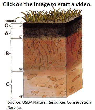
Soil profile
Soil Profile is a vertical sequence of recognizable horizons (pedologists use to distinguish from layer, which is used in geology and sedimentalogy) resulting from the development of a soil (pedogenic processes) over time. A hypothetical profile would comprise: organic horizons (H and O) and mineral (with some organic matter) horizons (A, E, B), and C (considered by some pedologists as a layer), and R (rock) layer. (Guidelines for soil description fourth edition)
The landscape relationship
Soil varies in space since there are different climatic zones in the world, it will have influence on soil forming processes. In dry areas, chemical weathering will be very slow resulting in slower soil formation. In wet tropics, chemical weathering will be much faster, this results in deeper soils. Also there will be plenty of organic matter, which will influence soil development. Another reason is that soil parent materials are different from one another because of differences in their mineral composition it is logical that soils derived from one parent material differ from other soils that are developed from other parent materials.
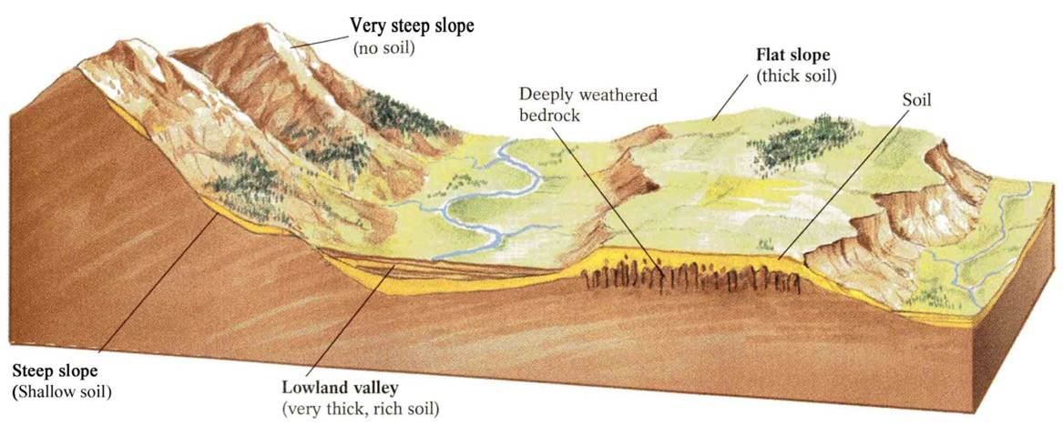
Figure 1: The effect of landscape on soil development.
Soil is the outermost layer of earth. It is derived from its parent materials (rocks). It is a natural body created by soil forming factors, which are climate (precipitation, temperature), relief(elevation, slope), organisms (flora and fauna) and time (thousands of years). Since parent materials can be different from one another in its mineral composition, it is logical that soils developed from one parent material can differ from other soils developed from another parent material. In addition, topography plays a very important role in soil formation. Soil in the mountainous areas can be different from soils in the flat areas. In figure 1 a schematics three dimensional view of landscape and soil occurrences is shown. Soils on the steep slopes are generally thin or nonexistent because water required for chemical weathering runs off such slopes and because any soil that does accumulate would wash away down the slopes. In the lowland valleys soils tend to be thicker, where water and loose material transported from upland area accumulate. Generally speaking soil tends to be thicker in lowland flat areas. In addition, the availability of water in lowland areas helps in chemical weathering of of bedrock. In very drier areas soil formation is generally very slow.
Soil variability
Soils have properties (physical and chemical) due to combined effect of the soil forming factors. Physical properties, such as the soil depth, particle size distribution, soil structure and soil porosity, determine soil moisture variations and movement of water into the soil body. However, chemical properties, such as the soil pH, organic matter content and plant nutrients (N, P, K), determine nutrient content of soil for plant growth.
Soils vary continuously within fields and between farms and soil heterogeneity has been discussed by Burrough (1993) because of factors operating and interacting at various spatial and temporal scales. The characterization of soil spatial-temporal variability is essential to achieve a better understanding of complex relations between soil properties, environmental factors and land use system (Yemefack, 2004). Soil clearly differ on regional scale (Brejda et al., 2000) and a great variability can be expected as the result of widely varying soil forming factors. At the field level, soil properties are influenced by human activities, such as the land uses and management strategies (Kotto-Same et al., 1997; Nye and Greenland, 1960). Soil performance and the crop yield can be affected by spatial variability of soil properties within a single field plot.
For further reading about soil variability:
watch a video:
https://www.youtube.com/watch?v=xsVNCEeOLiI
Soil mapping
Soil maps show soil classes (e.g., Podzol with a given set of properties, read also on podzol at Dinkel) and their distribution (e.g., a large area surrounding the island Dominica and the legend). Mapping soils means to make a map which answer the two different questions:
- What are the soil classes, for instance the Podzol (sandy) and heavier textured soils occurring along streams and the river?
- Where do they (soil classes) occur (extent/ distribution) in the surroundings of Dominica)?
Soil mapping starts with landscape stratification (subdividing terrain into meaningful units, on the basis of geomorphology, lithology, etc), by means of image interpretation. Image interpretation takes care of dividing the area (under study) into units, which are related to one or more soil classes, depending on the scale. Once the sites are known, the following steps follow. First, describing the soil profile by characterizing on the basis of which soils can be classified. Second, delineating the distribution/ extension, which is to answer a part of the above questions, by means of extrapolation. The extrapolation is done by applying geopedologic approach, where geomorphology and pedology are combined. 'œUnder similar environments in different places, soils are similar. This regularity permits prediction of the location of many different kinds of soil.' This is the backbone concept of the extrapolation.
Soil mapping is generally carried out by soil survey organizations. For example, in Thailand, the Land Development Department carry out soil mapping. In India, National Bureau of Soil Survey and Land Use Planning is responsible for soil mapping. ISRIC-World Soil Information is an independent institution, providing the soil data and soil maps at the global scale. The global soil data and maps with 1km grids can be downloaded from the website http://soilgrids1km.isric.org/. The spatial predictions are generated by using geo-statistics and and the outputs are validated by the experts. There is extensive collection of soil monoliths from around the world at the international soil museum (ISRIC), Wageningen.
For further reading about soil mapping:
http://www.charim.net/sites/default/files/handbook/datamanagement/3/3.6/Geopedology/soil_maps.html
The use of soil maps
Soil data is one of the important input factors for assessing risk due to landslide and flood hazard. Soil hydrological processes depend on soil properties. These processes are evapotranspiration, infiltration and percolation. Landslides often occur because of heavy rainfall that triggers groundwater rise, leading to lowered cohesion and instability in steep terrain. But there is not direct relationship between groundwater rise and rainfall, thus the soil water balance plays an important role.
Soil texture, porosity, field capacity and wilting point play an important role in soil hydraulic properties. Porosity is the total volumetric fraction of pores in the soil (or expressed as cm3 air/cm3 soil). Field capacity is the amount of water in a soil volume if gravity has drained all the relatively fast and free flowing water. This water is retained in the soil by capillary forces (the soil acts like a sponge).The wilting point is the water content of the soil that remains after plants have extracted all water they can through the roots. If the soil becomes dryer, the plants wilt (depends on the species, but for hydrological purposes plants are very similar). The hydraulic conductivity determines how fast water traverses a body of soil (water fluxes) and is expressed e.g. in mm/h or m/s. (Link)
The rise of groundwater in a slope is one of the major triggering factors of landslides. Groundwater fluctuates as part of the water balance: a rise in groundwater increases pressure in the soil-pore-system, which may counteract gravity and reduce cohesion. At a certain groundwater level, the resistance forces that keep a mass in place (its weight and cohesion) can be decreased to a point of slope failure. (Link)
For further reading about the overall soil knowledge and the soil maps:
Geopedology - An Introduction to Soil Survey, with Emphasis on Profile Description. '‹
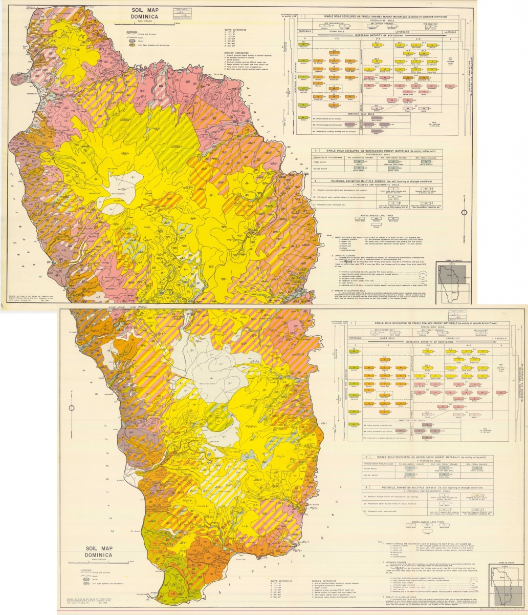
An example of a soil map for Dominica
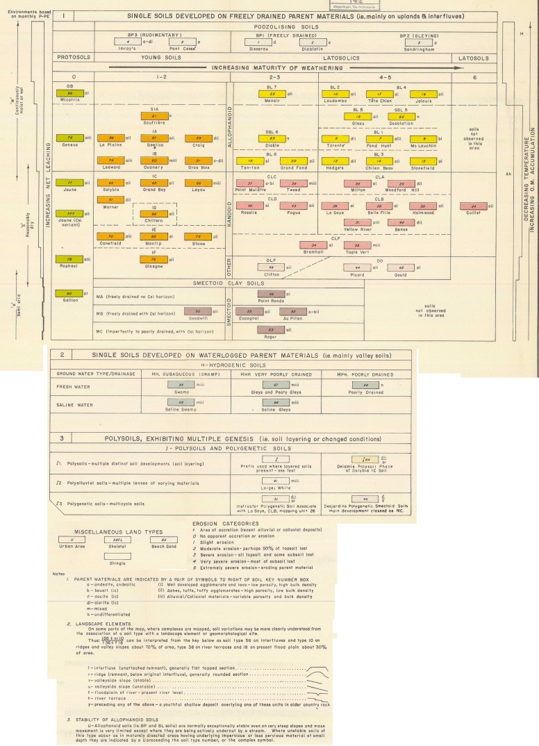
The available soil type map was generated in 1967 (Lang, 1967) through physiographic interpretation of aerial photographs, combined with field work and soil testing. The map consists of 2 map sheets, with a very complicated legend. There are over 100 different legend classes, and soils are named after a locality (most often an estate), with a suffix related to the parent material. This classification was made in order to identify agricultural fertility problems. For this the degree of weathering were estimated based on field observation data as pH, texture, structure and X-ray analysis on clay mineral content. Other factors were used as well such as parent materials, climate, plant and animal organisms, age of land and topography. The legend classes show a combination of the soil type (indicated as a number), the slope class and the erosion categories.
Four distinct soil types are important in Dominica, these are: smectoid soils, kandoid soils, allophane latosolics and allophane podzolics. Rouse et al. (1986) investigated the properties of these soil types which is summarized below.
- Smectoid soils (montmorillonite-rich): these soils occur in the highly seasonal parts of the island (annual rainfall below 2100 mm) where leaching is low, interrupted and incomplete. The montmorillonite content, together with an occasional cemented silica pan makes these soils impermeable when wet. Compared with the other soils of Dominica, smectoid soils have high subsoil dry unit weights and low porosities that ranges from 12.1 to 17.8 kN/m3 and from 0.36 to 0,61 respectively.
- Kandoid soils (mostly latosolics) (Kaolin/halloysite-rich): these soils typify areas receiving rainfall between 2100 mm and 3750 mm annually and a shorter duration of dry season, leaching is moderately intense and uninterrupted. Kandoid soils take a longer time to mature than smectoid and allophane soils, they are only found in older volcanic areas i.e. in the north and east part of the island. They have much lower subsoil dry unit weights (5.9 - 9.5 kN/m3) than smectoid and as a result their porosities are much higher (0.66 - 0.79).
- Allophane latosolics (allophane-rich): in areas with high annual rainfall greater than 3750 mm and no dry season, where leaching is intense and constant, allophane soils predominate. With continued leaching even the silica may be removed to form gibbsite, but because of the youthfulness of the relief and the effectiveness of the slope erosion, allophane latosolic soils tend to persist and indeed cover large parts of the island interior. Generally, these soils have very low subsoil dry unit weights and extremely low topsoil dry unit weights, 5.5 - 10 kN/m3 and 1.9 - 4.1 kN/m3 respectively. As a result, their subsoil porosities are very high (0.66 -0.81) and top soil porosities even higher (0.86-0.93).
- Allophane podzolics (allophane-rich): in the wettest areas with annual rainfall greater than 7000 mm, where leaching is extremely high, a peculiar variant of allophane is found. The allophane podzolics are characterized by deep litter and organic humic Ah horizons, a bleached highly leached subsoil, and a subsoil pan formed by accumulation of a complex of organic matter and amorphous sesquioxides. Their dry unit weights and porosities are higher than for allophane latosolics.
From the map, it is possible to observe that the main soil is Allophanoid Latosolics (Very highly permeable, low bulk density and at least 40% of matrix-clay size) occupying the middle area of the island. According to Lang (1967) Allophanoid soils (e.g. BP and BL soils) are normally exceptionally stable even on very steep slopes and mass movements are limited except when the slope is undercut by a stream. Where unstable soils of this type occur as in maturely dissected areas having underlying impervious or less pervious materials at small depth this is indicated in the map. Dominant soils in the northeast are Kandoid Latosolics (High to moderate permeability, low bulk density), and on the SW there are Young Soils (low water holding capacity, low bulk density and no less than 60% of matrix-clay size) and Smectoid Clay Soils (40 to 60% of matrix-clay size).
Click on the map to view an enlarged version of the map. Click on the legend below to view it in more detail.
 |
 |