

Summary
This use case addresses the potential relocation of the Milton Cato Memorial Hospital, St. Vincent. The current location is far from ideal as the hospital is located in a high risk flood zone. The general methodology that is developed in section 8.2 of the Method Book is applied to generate and analyze potential alternatives for a new location. In this process flooding, landslide, slope and accessibility criteria play a major role. As a result a number of locations in Kingstown are proposed for further evaluation.
Keywords:
Facility location planning, spatial constraints analysis, multi-criteria analysis
| Before you start: | Use case Location: | Uses GIS data: | Authors: |
|---|---|---|---|
| Methodology book section 8.2 gives an overview of this type of process | Using GIS Techniques to identify a suitable location for the relocation of the Milton Cato Memorial Hospital, St. Vincent | Yes, a GIS dataset is available with which the assessment could be done |
Mark Brussel, Andy Baptiste |
Introduction:
The Milton Cato Memorial Hospital is the most important health facility serving the island. It has a capacity of over 200 beds, and physicians of most specialties. It is located in the capital of St. Vincent, Kingstown, but, as it is the only hospital, people from all over the island make use of it. For emergencies and in case of people's inabilities to get to the hospital themselves, an ambulance service is operated. The hospital is located at Bentick Square, Kingstown, St. Vincent on the Leeward Highway. Figure 1. shows the location of the hospital on the island.
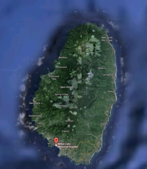
Figure 1: Map of location of hospital on the island of St. Vincent
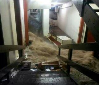
The hospital is located in a flood prone area. Regularly, the lower parts of the hospital are flooded and wards need to be evacuated. The floods, although usually of short duration, have a devastating effect and lead to severe damages to the inventory of the hospital (Figure 2). The flooding and high winds also cause damages and major structural and construction deficiencies in the existing complex. In addition, the hospital is suffering from severe access restrictions in view of the transport situation in Kingstown. The access problem is severely aggravated in episodes of flooding.
 |
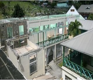 |
| Figure 2: Flooding at the hospital | Figure 3: Structural damage |
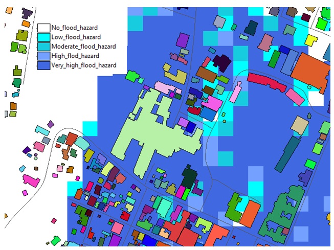
Figure 4: Location of Cato Memorial hospital (large building in green) on the flood map of St. Vincent
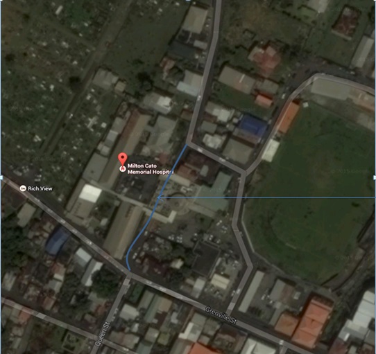
Figure 5: Photo showing existing drain running under the hospital
An example of a recent flood that caused extensive damage was the flood that occurred on 25 December 2013, after a rainfall of over 300 mm over a 24-hour period in Saint Vincent. Among the affected critical infrastructures was the Milton Cato Memorial Hospital. The Ministry of Health, Wellness and the Environment (MoH), estimated the damages at 2 million East Caribbean dollars.
The flood prone location of the hospital was confirmed by a GIS based overlay analysis with the national flood hazard map that was produced under the CHARIM project (refer to the chapter on the Saint Lucia National Flood Hazard Map Methodology and Validation Report) (As yet no chapter number in the handbook). Figure 4 presents the results of this analysis. As can be seen from this figure, the hospital building (in green) in its entirety falls in the highest flood level category: very high flood hazard. It is a relatively flat piece of terrain that is also difficult to drain. Local mitigation measures that have been taken such as the construction of a subsurface drain below the hospital have not produced a significant improvement. Flooding therefore constitutes a major hazard at the location.
In terms of remedying this situation there are a few basic options: The first is implementing local level mitigation measures that would focus at reducing the flood risk and would improve the structural conditions of the building in such a way as to reduce risk of damage in the future, while at the same time addressing the transport situation and the limited access. The second option would be to relocate the facility to a more appropriate location. The third would be to spread medical facilities and services to various facilities over the island. This use case focuses on the second option, relocation, in particular.
Objectives:
The objective of this use case is to show a method for analyzing possible alternatives for the relocation of a hospital.
Flowchart:
To determine a suitable location, a certain methodology will be followed as indicated in the flowchart shown below. The methodology applied is derived from the methodology section 8.2 of this handbook, where it is explained along with the whole analysis procedure. The reader is advised to go through that section also to get a general overview of methods and concepts that apply. In this particular use case, which can be seen as an illustration of the methodology, a more limited (in terms of the number of steps involved) and a more qualitative (in terms of certain parts of the analysis) approach will be followed mainly in view of a lack of data and the absence of stakeholders and policy makers in the process. These limitations are explained below.
In a typical facility planning procedure, a demand analysis is made in which the service area of the facility is determined and the number of potential clients determined. In the absence of data on population and health services requirements, we do not carry out such a demand analysis in this use case. We conclude that a supply analysis is not needed, as there is only one hospital in the entire island and therefore no situation exists where its relocation choice would be influenced by competition with another hospital. We therefore start our process with the definition of the study area which is considered to be the search area for the new facility.
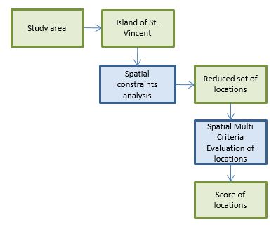
Figure 6: Main methodology flowchart
Use case study area description:
The study (or search area) is in principle the whole Island of St. Vincent, as the hospital facility needs to provide services for all inhabitants of the island. Also the Government has the right to acquire lands at any point if required to carry out essential Government tasks. Therefore, in the initial analysis, the whole island is considered, the only locations that will be excluded are the Grenadines in view of the population concentration in Kingstown. To this data set we have applied various constraints to determine a reduced set of locations.
Problems definition and specifications:
For the hospital relocation in St. Vincent a number of requirements need to be fulfilled. These requirements would normally be based on a political process which would include stakeholder consultations. In the absence of such process, in our view the most important requirements are:
- The new hospital must be easily accessible for everyone and will take into account the accessibility of the Grenadine islands.
- The new hospital should not be located in high hazard zones.
- The new hospital should be planned on land that is either government land, or land that can be acquired with relative ease and acceptable cost.
Data requirements:
In our methodology we have used spatial flood hazard and landslide hazard data, as these are the types of hazards considered in the CHARIM project. In addition we have used slope data, roads data and building data.
In principle also other (spatial and non-spatial) data can be introduced as per the requirements of the stakeholders. This could be of a more economic nature in terms of site development cost, land acquisition costs, service catchments, environmental effects and others.
Other Requirements
For the hospital relocation in St. Vincent a number of requirements need to be fulfilled. These requirements would normally be based on a political process which would include stakeholder consultations. In the absence of such process, in our view the most important requirements are:
- The new hospital must be easily accessible for everyone and will take into account the accessibility of the Grenadine islands.
- The new hospital should not be located in high hazard zones.
- The new hospital should be planned on land that is either government land, or land that can be acquired with relative ease and acceptable cost.
Analysis steps:
Spatial constraints analysis
This analysis is carried out to reduce the set of potential locations in order to find a suitable location for this hospital.
This is done using constraints analysis in the ILWIS software.
The following four hard constraints were used to limit the number of potential locations.
- Flood Hazard. The suitable area must not be located inside high hazard areas, as determined by the flood analysis that was performed under the CHARIM project.
- Landslide susceptibility. The suitable location must be outside of landslide prone areas, as based on the landslide analysis that was performed in the CHARIM project.
- Slope - The suitable location must be in a low slope area to avoid additional cost and difficulty in terms of construction of the facility
- Accessibility - The suitable location must be within 500 m of an existing main road as this provides for proper accessibility without having the need to construct a lot of additional and costly roads.
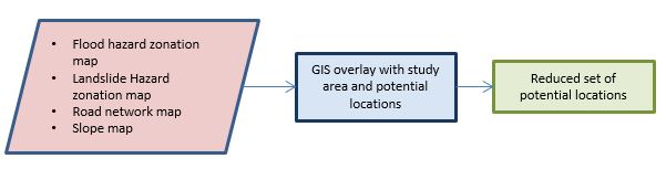
Figure 7: Flowchart of constraints analysis
In the ILWIS software these constraints have been analyzed spatially, with the use of raster maps.
- Flood Hazard
For the flood hazard analysis we have used the national flood hazard map that is produced under the CHARIM project. (see Saint Lucia National Flood Hazard Map Methodology and Validation Report, ) (As yet no chapter number in the handbook).
The output of such flood model to a large extent depends on the quality and spatial resolution of the input data - DEM, soil and hydrological characteristics, channel and physical object data in particular - and its application should be discussed against the background of the data used and its quality.
Being a national level analysis, it may be that for local flood hazard assessment more detailed studies are needed. This will be in particular the case for detailed engineering studies into the design of flood mitigation measures, site development and building construction.
For the application in this use case however, we are in first instance interested in flood extent, which is primarily based on DEM, channel and catchment characteristics. We believe the quality of the national flood level analysis is sufficient to identify the approximate areas where flooding will occur, to exclude locations on that basis and to evaluate potential locations where no flooding occurs. However, for a final choice of location and for more detailed design studies additional local level information may need to be collected and used in a more detailed model.
In this use case, we are basically interested in flood extent. We do not wish to locate the new hospital in a location where any flood hazard is present, we only look for areas that are hazard free. Therefore we classify the existing flood hazard map that is composed of 5 classes into 2 classes, the areas that flood are assigned the code "flood", whereas the areas that do not flood are assigned the code "no_flood". Suitable locations are only allowed in the areas that do not flood.
The national flood hazard map contains the following classes and is classified and reclassified as indicated in the table below:
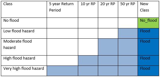
The resulting map shows the results for the southern part of the island, where the suitable areas are in green and the flood hazard areas are in blue.
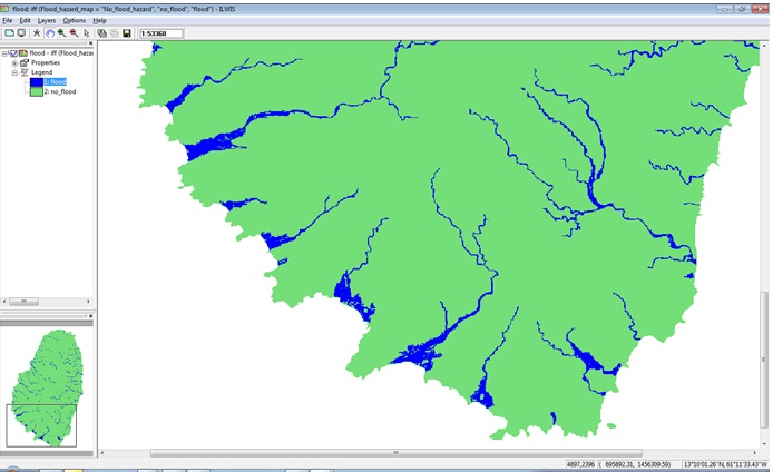
Figure 8: Flood suitability map
- Landslide susceptibility
Here we identify suitable locations as those that must be outside of landslide prone areas. Making use of the landslide susceptibility map that has been produced in the CHARIM project we only allow locations to be suitable if they are of low landslide hazard, by excluding those areas that are medium or high landslide hazard. The map below shows the suitable areas in green and the non-suitable in red.
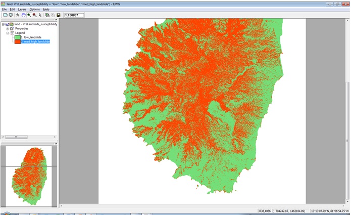
Figure 9: Landslide suitability map
- Slope
Here, we carry out a similar procedure based on a slope map that is derived from the digital elevation model of St. Vincent. Although technically constructions can be designed for areas with higher slopes, we exclude sites that have medium to high slopes, as construction in those areas is costly. Considering that the required area of the hospital will be around 1 ha, the height difference to be incorporated in the construction and site preparation is already 10 vertical meters for a 100x100 m site, or the equivalent of 3 stories. We therefore consider steeper terrain as not suitable.
The slope map was classified into 3 classes of low, medium and high, based on the table below. Afterwards, a map was created with only the low slopes as suitable areas, using a similar procedure.
This map is shown below with the low slopes in green and the higher slopes in red.
|
Range of slope |
Boundary |
|---|---|
|
Low |
10 % |
|
Medium |
20 % |
|
High |
Above 20 % |
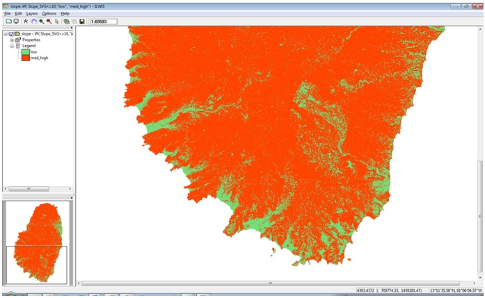
Figure 10: Slope suitability map
- Access
Road connectivity to the hospital is very important, for emergencies, for patients and for employees. In order not to construct a lot of additional roads, a constraint was put on the distance of the new hospital location to the existing main roads.
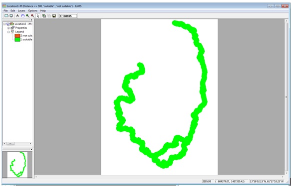
Figure 11: Road suitability map
We have taken a threshold of 500 m in the analysis. Using the road dataset, only the main leeward and windward road were considered and buffered for a distance of 500 m. This procedure created the following map:
Final constraints map
The four maps developed above, were combined into a final constraint map through an overlay procedure in GIS, indicating the potentially suitable areas in green.
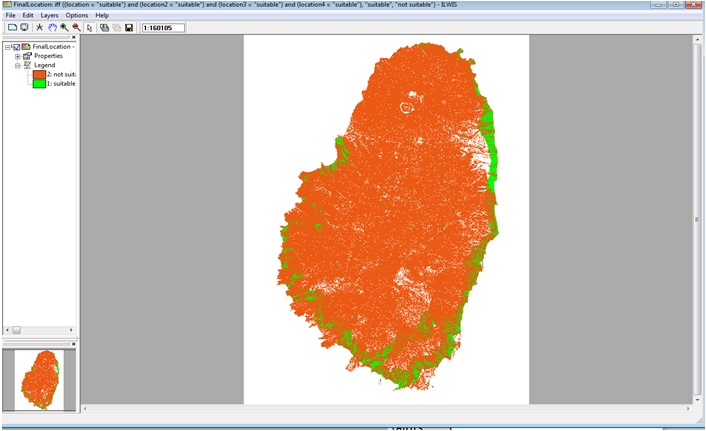
Figure 12: Final suitability map
As can be seen from this map, the number of areas that is available based on the constraints identified is very limited. Moreover, it is also observed that most of the suitable locations are occupied by a lot of buildings already. The spatial analysis reflects that there is very little suitable land available for development in the Kingstown area in particular. Therefore, in the next step, it was decided to look more closely at some potential areas in relation to the built environment, to come up with a number of candidate sites.
In this phase of the process, we have looked at the Kingstown area only. In view of the large concentration of population in this area, and in view of its connections to the Grenadines, basically the Kingstown area is considered to be the main suitable area as travel times for large sections of the population will be too long in case locations elsewhere on the island are considered.
An inventory was made using satellite imagery, building footprint maps and the final suitability map. This yielded only three potential locations, these are discussed below:
- An area close to the main library in Kingstown
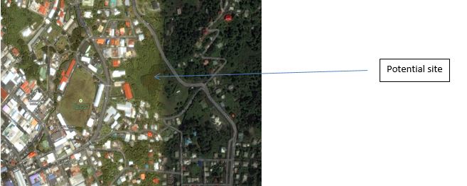
- An area in Arnos vale above the cricket stadium close to the airport
- An area in Ratho mill
- Main library in Kingstown
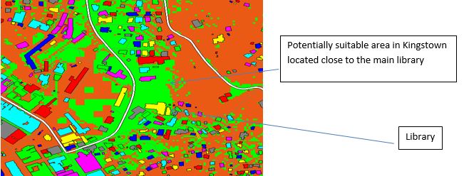
Potentially suitable area in Kingstown located close to the main library
A qualitative assessment of the sites was made, identifying the advantages and disadvantages, as follows:
Advantages:
- Located in the capital
- Easily accessible
- Government owned lands
- In principle enough land space for a proper facility
Disadvantages:
- Very close to the newly constructed library and other built up areas like schools.
- Buildings will have to be removed/adjusted
- Part of the area is currently occupied by government buildings, there will be cost involved in modification.
- Arnos vale
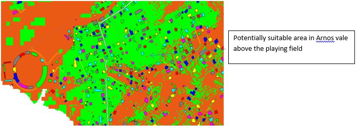
Potentially suitable area in Arnos vale above the playing field
Advantages:
- Relatively flat lands.
- Enough land space
Disadvantages
- There are quite a lot of houses within the area that would need to be relocated, which is expensive.
- Potentially a noisy neighborhood
- About 20 minutes' drive from central Kingstown provided there is no traffic.
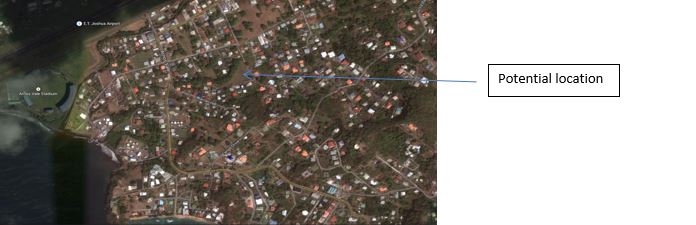
3. Ratho Mill
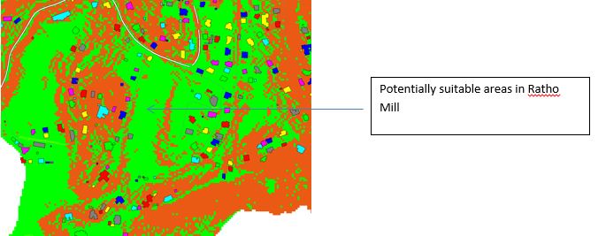
Potentially suitable areas in Ratho Mill
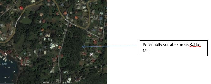
Potentially suitable areas Ratho Mill
Advantages:
- Few built up areas.
- Flat lands
Disadvantages
- Relatively far from the capital, accessibility is lower.
- Mostly private lands, possibly expensive to acquire
- Green and forested area would need to be cleared.
Multi-criteria evaluation of possible alternatives
After the above analysis, we have three alternatives (the three potential areas) that can be evaluated through a multi-criteria evaluation procedure. In such a procedure these three identified areas can be compared and the best one chosen. In addition, for example if the analysis does not create satisfying results, other alternatives could be incorporated, to be able to make a broader comparison.
The figure below, which is discussed in the Methodology Book section 8.2 gives an overview of such process. It is up to the local stakeholders to determine which criteria are important and should be incorporated. It may also up to the local stakeholders how to score these criteria maps and how to weight them. In the absence of stakeholders and because we do not avail of detailed information to carry out cost and other calculations, this analysis is not performed here, only the principle is explained.
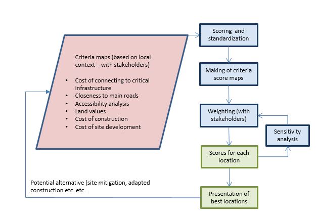
Figure 13: Multi-criteria evaluation procedure
In this approach, for each of the potential sites, criteria maps can be evaluated, on aspects such as those that are indicated in Figure 13. With the help of Spatial Multi Criteria Evaluation the scores of the three locations can be calculated and analyzed, given the set of chosen criteria, and the best location can be determined.
Conclusions:
- The GIS techniques used allow for a fast and value free analysis of which areas are potentially suited, based on user-identified criteria. In particular, the spatial hazard related phenomena can only be analysed in such manner, as they are spatial phenomena. Such analysis is indispensable in high hazard areas.
- The natural situation that St. Vincent is in, with regards to the topography of the terrain and the flood and landslide hazards severely reduces alternatives for development. Those areas that are suited, are already developed to a large extent, and space is very scarce, particularly for large facilities like a hospital. It is important that an integral view to territorial development is taken by the government, which would allow for the hospital facility as well as other facilities to be developed.
- The relaxation of hazard related criteria would lead to more areas being potentially suitable, however, this would come at the cost of mitigating against these risks locally. Whether mitigation is a sensible strategy would depend very much on the particular location and the hazard involved, however, for a facility the size and economic value of a hospital, it will be very costly by definition. In general it may be more useful to locate lower value land use functions in more hazardous areas as compared to a high level function like a hospital.
Recommendations
- It is recommended that a multi-disciplinary team would be set up to carry out the SMCE analysis, composed of at least one delegate from the different agencies, as additional data would be needed to carry out the evaluation.
- The up-to-date-ness and quality of data and maps needs to be secured to enhance the quality of the analysis and the decision making. E.g. some buildings were missing from the buildings dataset that was used, which may lead to a wrong interpretation of available space.
Last update: 26 - 05 - 2016