

 Summary:
Metadata is a summary document that provides information (content, quality, type, creation, spatial information) on a data set. It is "data about data". It stores who made a data set, when, how , with which accuracy, how often it is updated. It is essential information that other persons or organizations need to know before they can use the data.
Authors: Dr. Manzul Kumar Hazarika , Mr. Chathura Wickramasinghe and Cees van Westen
Keywords: Metadata, standards, ISO
Links:
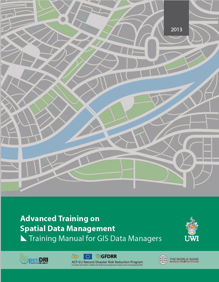
- The Advanced training course on Spatial Data Management developed by OpenDR, GFDRR and UWI has a chapter on metadata. Click on the image to open it.
- https://www.fgdc.gov/metadata/geospatial-metadata-standards
- http://www.esri.com/library/whitepapers/pdfs/metadata-and-gis.pdf
Introduction
Metadata is a primary interoperability enabler, providing information that is not apparent in the object itself - how old is it, when was it created, how was it made, where did it come from etc. Metadata is commonly defined as " data about data", information that provides an understanding of a resource, which can be in many forms - a service, an application, a web service, data, a database field, or just about any conceivable information technology resource. Although the concept has been around a long time, the term metadata came about during the information technology (IT) age. Within the field of information technology, metadata is data that describes the information so that it will be useful and have value, be understandable, and enable collaboration. Collaboration is interoperating toward a common end - the ability to share, exchange, and use information.
Metadata allows us to find, understand, and use the right resource for the right reason, and use it correctly. This applies to geospatial metadata as well; most metadata element types that serve non-geospatial metadata are used to describe geospatial metadata as well. However, to describe geospatial resources, geospatial metadata must fulfill additional requirements. Examples are the geographic area to which the resource applies, abstraction methods, coordinate system used, datum, positional quality, etc. Geospatial metadata also provides information that allows resources to be discovered by interested parties searching for resources, evaluated, accessed, and understood, enabling proper utilization.
Objectives
Provide an introduction to geospatial metadata standards and requirements.
Description
To truly enable interoperability, metadata must be widely understood. Users need to understand what metadata needs to be produced and what should be available to understand a resource. The metadata must be understandable by anyone using it. This is what makes standardized metadata so powerful and important. Standards precisely define how geographic information and related services should be described, providing mandatory and conditional metadata sections, metadata entities and metadata elements. This standard applies to data series, independent datasets, individual geographic features and feature properties. To this end, many national geospatial metadata standards exist today as well as international metadata standards to promote global interoperability.
Geospatial Metadata Standards
A standard is defined as an agreement between a provider and a consumer, providing reference documents to be used in public contracts and international trade. When it comes to geospatial metadata, the foremost aim of standards is to facilitate the ability to describe, manage, query, exchange, transmit, share and integrate geospatial data and information. Metadata are generally categorized as mandatory and non mandatory, the mandatory metadata are focused on metadata for locating datasets, allowing them to be exposed for discovery. The requirement of metadata can be varied and certain type of metadata elements can be essential based on the use or application of relevant data and adopted standards.
National Metadata Standards
Many standards are established by nations for national benefit, due to the fact that it is easier to develop a national system rather than adopting an international system when the existing systems for geospatial data collection is different or when unique set of metadata is required to be collected.
USA is the pioneer in developing the first national metadata standard and in 1994, the Federal Geographic Data Committee (FGDC) [1] was tasked by an Executive Order to develop procedures and assist in the implementation of a distributed discovery mechanism for national digital geospatial data. FGDC then developed the Content Standard for Digital Geospatial Metadata (CSDGM) and it was done from the perspective of availability, fitness for use, access and transfer. The objectives of the CSDGM standard were to standardize a set of terminology and definitions and information about values to be provided for the documentation of digital geospatial data. The standard stated the major uses of metadata as: 1) to maintain an organization’s internal investment in geospatial data, 2) to provide information about an organization’s data holdings to data catalogs, clearinghouses, and brokerages, and 3) to provide information needed to process and interpret data to be received through a transfer from an external source.
FGDC recommended a set of mandatory metadata elements that can be used as a template for developing metadata. These mandatory metadata are divided into seven element categories as described in Table 1 below.
Table 1 Mandatory metadata elements (FGDC)
|
Section |
Mandatory Metadata Elements |
|---|---|
|
1) Identification |
Originator, Publication Date, Title, Abstract, Purpose, Time Period of Content, Currentness Reference, Progress, Maintenance and Update Frequency, West Bounding Coordinates, East Bounding Coordinates, North Bounding Coordinates, South Bounding Coordinates, Theme Thesaurus, Theme Keywords, Access Constraints, Use Constraints. |
|
2) Data Quality |
Logical Consistency Report, Completeness Report, Process Description, Process Date. |
|
3) Spatial Data Organization Information |
Direct Spatial Reference Method. |
|
4) Spatial Reference Information |
Ellipsoid Name, Semi-Major Axis, Denominator of Flattening Ratio, Horizontal Coordinate System, Spatial Resolution. |
|
5) Entity and Attribute Information |
Entity and Attribute Overview, Entity and Attribute Detailed Description. |
|
6) Distribution Information |
Distributor Contacts, Distribution Liability |
|
7) Metadata Reference |
Metadata Date, Metadata Contact, Metadata Standard Name, Metadata Standard Version. |
International Metadata Standards
The CSDGM may perhaps be the most widely used national metadata standard today, and many countries around the world have adopted it. Its use, however, is now being surpassed by the ISO 19115 metadata standard, which is more internationally focused. International standards are developed for a wider audience to promote interoperability between nations and around the globe. The CSDGM is expected to be phased out in USA and it is being replaced by the North American Profile of ISO 19115 developed under the leadership of the FGDC (USA) and Natural Resources Canada for use throughout the North America.
Many of the National Spatial Data Infrastructure (NSDI) stakeholders have long utilized the CSDGM, and it will continue to have a legacy for many years. However, using an international standard has its benefits, when working collaboratively and the International geospatial metadata standard, ISO 19115, is emerging. The standard is part of the ISO geographic information suite of standards (19100 series). ISO 19115 and its parts provides information about the identification, the extent, the quality, the spatial and temporal aspects, the content, the spatial reference, the portrayal, distribution, and other properties of digital geographic data and services. The following sections provide insights about the international metadata standards.
ISO 19115:2003 Geographic information - Metadata and Technical Corrigendum 1:2006 [2]
This standard defines the schema required for describing geographic information and services. The standard applies to all geographic resources - it is applicable to datasets in series, datasets, individual geographic features, and their attributes. It is also applicable to geospatial services. The standard defines the minimum set of metadata required to serve the basic metadata functions such as resource discovery, determining a resource’s fitness for use, and resource access, as well as optional metadata elements to support a more extensive description enabling a wide range of metadata applications.
ISO 19115-2:2009 Geographic info. - Metadata - Part 2: Extension for imagery & gridded data [3]
This is an extension of ISO 19115 defining additional metadata elements required to describe imagery and gridded data. Imagery is data that represents phenomena as images produced by electronic and/or optical sensors, and gridded data is data containing attributes associated with positions on a grid coordinate system. The base standard, ISO 19115, provides the majority of the metadata describing imagery and gridded data; part 2 provides additional metadata describing the planning, acquisition, and measuring equipment used in the production of the data, and extended descriptions of the processing steps used in refining the data. The standard extends the UML model and data dictionary.
ISO/TS 19139:2007 Geographic information - Metadata - XML schema implementation [4]
This standard provides a rule-based encoding for ISO 19115 Metadata in XML, providing technical interoperability. It defines geographic metadata XML encoding (gmdXML) automatically created using the UML models following the encoding rules defined in ISO 19118. Where appropriate, it takes advantage of GML and other previously defined XML encodings. In addition it contains clauses defining cultural and linguistic support, metadata for transfer, dataset and aggregate dataset metadata, and code-lists.
ISO 19113:2002 Geographic information - Quality principles [5]
This standard defines the canons for describing the quality of geospatial data and specifies metadata elements for reporting the information. Geospatial data quality is defined as the characteristics of a geospatial resource that allow it to satisfy stated and implied needs. Data producers should provide this data quality information stating how well a dataset represents a Universe of Discourse as defined in a product specification. Users can then evaluate the data quality information to determine a dataset’s fitness for their application.
ISO/TS 19138:2006 Geographic information - Data quality measures [6]
This standard normalizes the components and structures of data quality measures, guiding producers in choosing the right measures when reporting dataset metadata and ensuring that users are presented with relevant and comparable measures when choosing the right dataset for their purposes. It is closely related to ISO 19113, which establishes principles and specifies components to be used for reporting quality information, and to ISO 19115, where data quality measures are reported.
ISO 19110:2005 Geographic information - Methodology for feature cataloguing [7]
This standard defines a methodology for cataloging feature types as well as how a classification of feature types is organized into a feature catalog. A feature catalog is a catalog containing natural-language definitions and descriptions of the feature types, the feature’s attributes, operations, and associations provided as geographic data.
ISO 15836:2009 Information and documentation - The Dublin Core metadata element set [8]
This standard defines a simple set of metadata elements for describing a wide range of networked resources that are designed for search and retrieval in catalog and web environments. Dublin mandatory metadata is a simple set of metadata elements that can be easily produced and widely understood, and that promotes broad cross-domain interoperability (Table 2).
Table 2 Dublin mandatory metadata elements (ISO)
|
Metadata Element Types |
Definitions |
|---|---|
|
Title |
A name given to the resource |
|
Creator |
An entity primarily responsible for making the content of the resource |
|
Subject and keywords |
A topic of the content of the resource |
|
Description |
An account of the content of the resource |
|
Publisher |
An entity responsible for making the resource available |
|
Date |
An entity responsible for making contributions to the content of the resource |
|
Type |
A date of an event in the lifecycle of the resource |
|
Format |
The nature or genre of the content of the resource |
|
Identifier |
The physical or digital manifestation of the resource |
|
Source |
An unambiguous reference to the resource within a given context |
|
Language |
A reference to a resource from which the present resource is derived |
|
Relation |
A language of the intellectual content of the resource |
|
Coverage |
A reference to a related resource |
|
Rights |
The extent or scope of the content of the resource |
Metadata in GeoNode
Metadata is a very important component in GeoNode, because it provides the information about a certain data layer, map or document that other users will need in order to understand how the data were made, by whom, when with which accuracy. By providing additional information about the layer after it has been uploaded, you are able to specify the data and make the layer more accessible to other users. After a layer has been uploaded, or if you are in the Layer View interface, you can use Edit Metadata to start providing more information about your layer. Some fields are automatically filled in, but most are left empty for you to provide information.
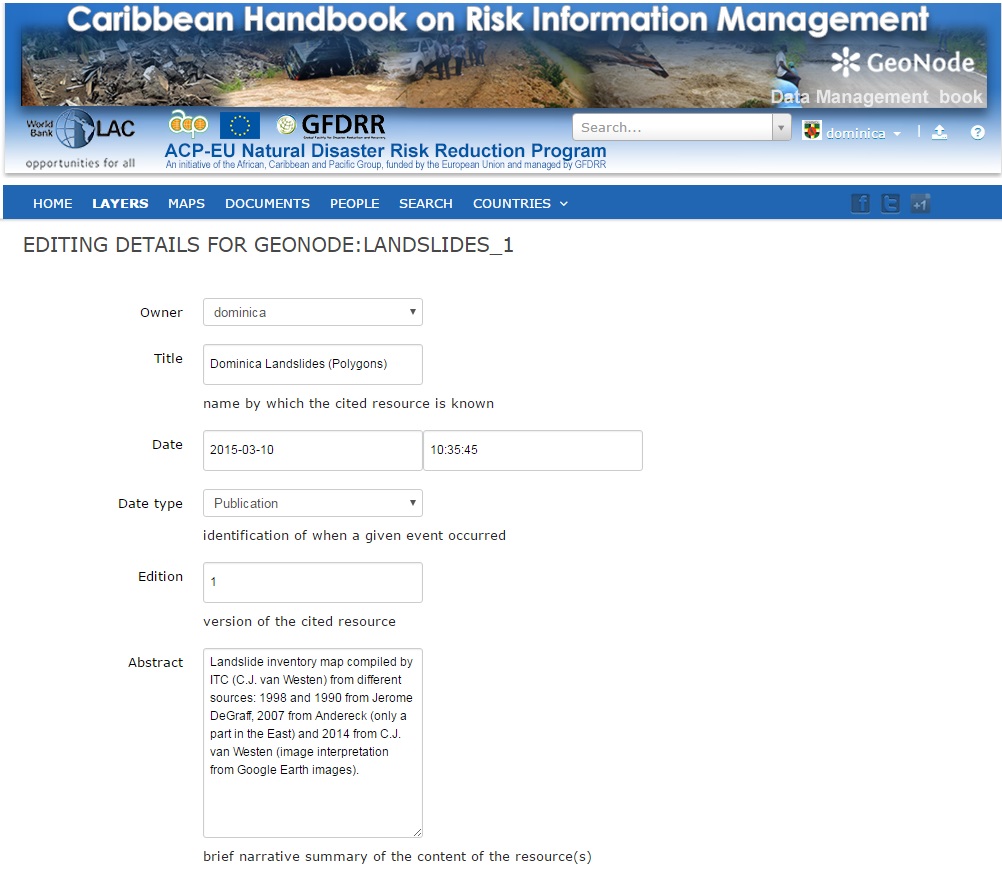
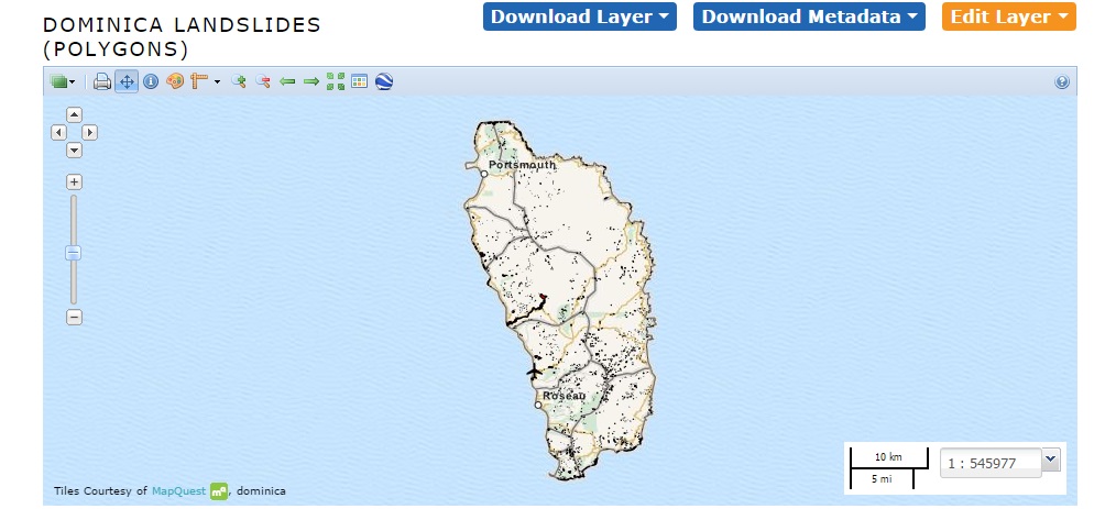
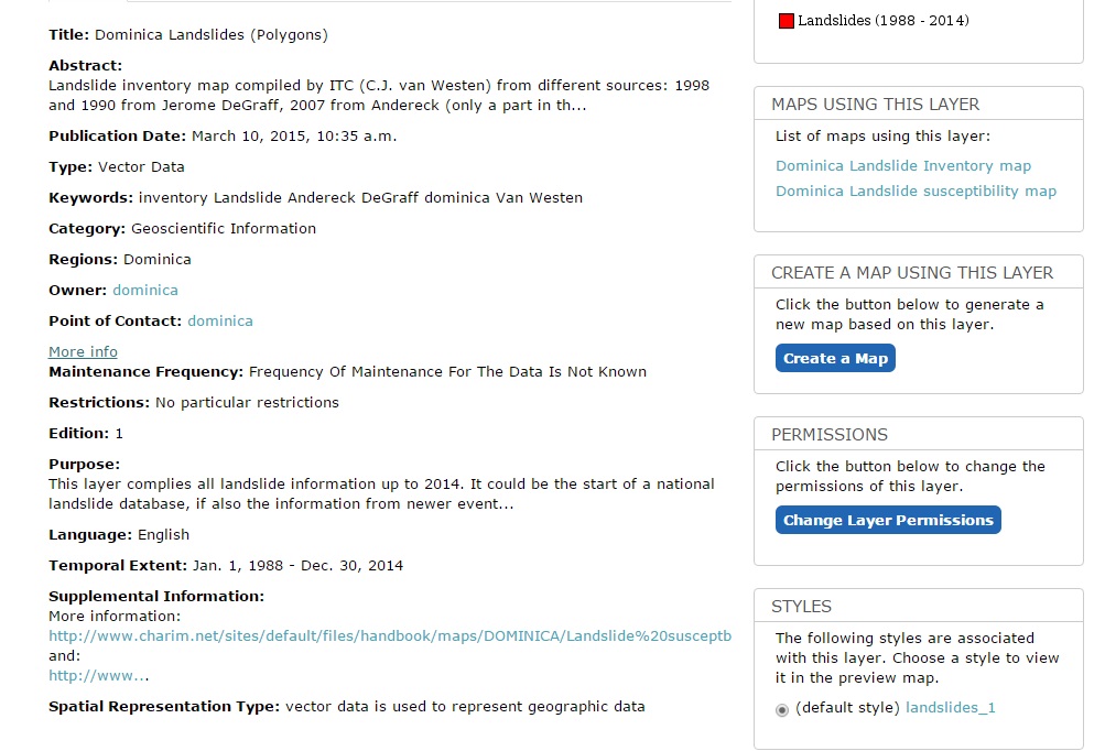
Below an example is giving for one data layer: Landslides in Dominica
The first part explains about the owner of the data, the date it was uploaded, the data type, and the abstract. The abstract is very important as it gives other a direct description of what it is.
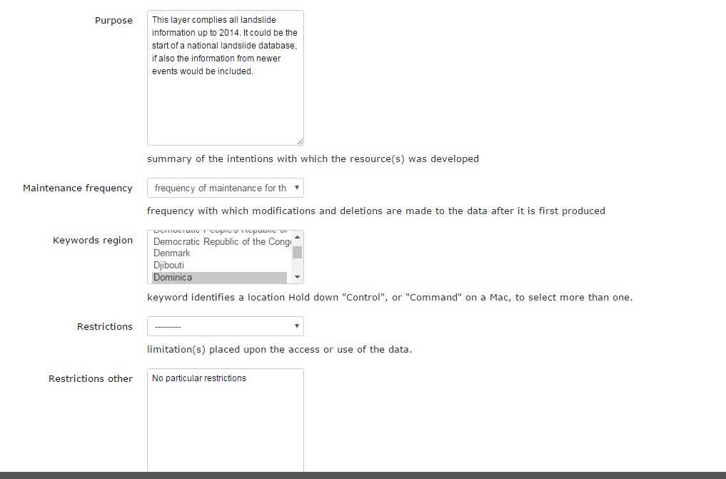
The second part explains the purpose of the data layer (why was it made), the maintenance frequency, the country, and if there are restrictions to the use of the data.
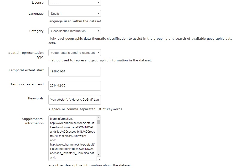
The third part explains about the langauge used in the data, the category of data, the spatial representation type, the time of start and completion of the data, keywords and important supplemental information.
The fourth part explains the URL used for distribution, and the data quality statement.
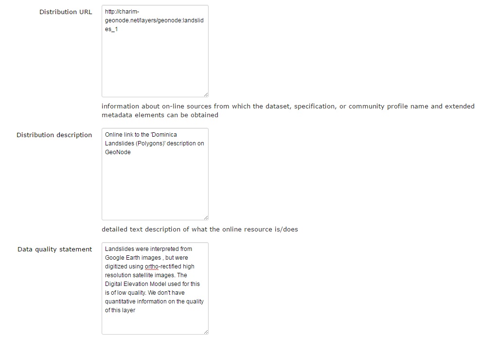
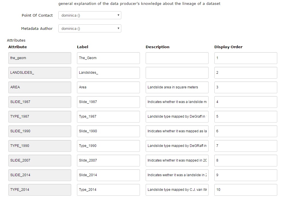
The fifth part contains the point of contact, and metadata author, and describes each of the attribute fields in the attribute table linked to the data layer.
After entering the Metadata, the results will look like below: http://charim-geonode.net/layers/geonode:landslides_1
References
[1] FGDC (1998). FGDC-STD- 001-1998. Content standard for digital geospatial metadata.
[2] ISO (2003). ISO 19115:2003/ Corrigendum 1: 2006 Geographic information - Metadata.
[3] ISO (2009). ISO 19115-2:2009 Geographic information - Metadata - Part 2: Extensions for imagery and gridded data.
[4] ISO (2007). ISO/TS 19139 Geographic information - Metadata - XML schema implementation.
[5] ISO (2002). ISO 19113 Geographic information - Quality principles.
[6] ISO (2006). ISO/TS 19138 Geographic information - Data quality measures.
[7] ISO (2005). ISO 19110 Geographic information - Feature cataloguing methodology.
[8] ISO (2009). ISO 15836 Information and documentation - The Dublin Core metadata element set.