

Before you start: http://www.logcluster.org/
Authors: Dr. Manzul Kumar Hazarika and Dr. Firman Hadi
Keywords: Accessibility, Logistic Cluster, SDI-T
Introduction
Accessibility to disaster-affected areas through roads is a very important from disaster management point of view. At the time of a disaster, accessibility plays a critical role in evacuation, rescue and relief activities.
In 2005, the United Nations established the Logistics Cluster as one of nine inter-agency coordination efforts in humanitarian assistance, recognizing the key importance of logistics in aid operations. The Logistics Cluster develops operational systems and tools to assist humanitarian organizations in optimizing their preparedness and response to emergencies, in managing and coordinating their logistics operations.
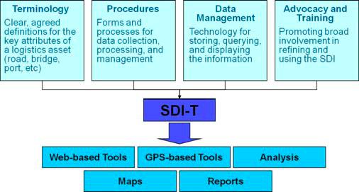
The Logistics Cluster has the responsibility of road data collection from various sources such as pre-existing geo-datasets, digitization from hardcopies of maps, field missions, interviews etc. to prepare the Spatial Data Infrastructure Transport (SDI-T), which is the core database providing data on roads and other logistics infrastructure such as bridges, obstacles, warehouses etc. Transport overview methodology, procedures and standards for symbology and typology have already been defined and are used during each field emergency operation. The SDI-T database was launched on June 2008 with direct impact on data preparedness in addition to operational support for many countries.
Objectives
Provide up-to-date information on roads for emergency operations.
Description
The Logistics Cluster maintains the transport related data and information. Baseline data is provided in a fixed template for a specific country containing key information for logistics operations - this is static information and requires updating on a regular basis.
Logistics assessments build on information derived from needs assessments to ascertain how to meet identified needs through delivery. The challenge is to be able to respond to the need for humanitarian aid by assessing the most appropriate form of transport to destination areas, using the most viable routes and ensuring that appropriate assets are available to fulfill the delivery needs. Delivery will be affected by the condition of the infrastructure, requiring a transport/movement assessment.
Logistics emergency preparedness depends on up-to-date data collected from various sources, with information from the field being the most important and valuable. In order to make this logistics information available for any member of the humanitarian community who would need it when an emergency arises, general logistics planning maps for the countries of concern are regularly updated and published through SDI-T GeoPortal. It is a web mapping platform providing SDI-T related tools, including GIS functionality, for Logistics Clusters and humanitarian logisticians in the field. The SDI-T version of Geoportal allows users with Internet access anywhere in the world to visualize in real-time, extend individually and download transport data such as roads, airports and ports from the SDI-T database.
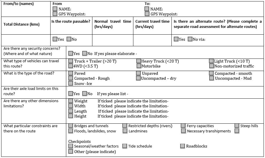
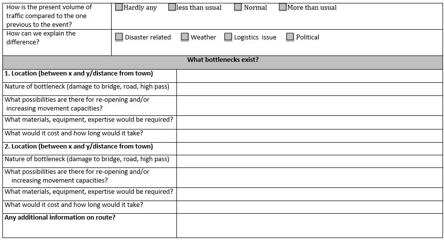
During an emergency the Logistic Cluster respond immediately to meet maps and data requirements. During operations, the GIS Unit of Logistic Cluster continuously compiles and integrates new geographic data relevant to logistics infrastructure in the countries of concern identified by the humanitarian community. Information collection is standardized in the form of a road conditions reporting form (Table 1), which enables information to be collated and represented in a map and includes the following data:
- Travel distance and time;
- Security concerns;
- Type of the road;
- Axle load limits;
- Limitations related dimensions;
- Constraints on the route;
- Volume of traffic compared to the one previous to the event;
- Volume of traffic now and how to explain the difference;
- Bottlenecks
Table 1: Road Assessment Form
Last update: 19-07-2016