

Before You Start
http://docs.qgis.org/2.2/en/docs/user_manual/working_with_ogc/ogc_client_support.html
Authors
Dr. Manzul Kumar Hazarika and Mr. Ramesh De Silva
Introduction
GeoNode is an open source platform that facilitates sharing and collaborative use of geospatial data. This tool surpasses existing spatial data infrastructure solutions by integrating robust social and cartographic tools. At its core, GeoNode is built on a stack based on GeoServer, Django, and GeoExt that provides a platform for sophisticated web browser spatial visualization and basic analysis. It provides a map composer and viewer, tools for basic analysis, and reporting tools. Hence, it is an ideal tool to use as a geospatial data sharing platform. It gives you an out of the box product, which is ready to be used soon after the installation. It is possible to make certain customization but one should not disturb the original architecture of the system. For an example, GeoNode creates a new table in its PostgreSQL/ PostGIS database for each vector dataset you upload.
GeoNode allows to upload vector and raster data in their original projections. Vector data are uploaded in ESRI Shape file format whereas the satellite images and other kinds of raster data are uploaded in GeoTIFF format.
Objectives
- Understand GeoNode supported data formats;
- Explain the basic operations of GeoNode;
- To identify strengths and limitations of GeoNode;
- To find ways to address requirements beyond the scope of GeoNode.
Geonode Supported Data Formats
An XML file called Styled Layer Descriptor (SLD) defines a vector layer's default style. Styled Layer Descriptor files can be created using desktop tools such as AtlasStyler, ArcMap2SLD, or Arc2Earth. GeoNode also provides a web-based styler that allows the user to change data looks and preview in real time. When uploading a vector layer (shape file), it is mandatory to provide following four files.
- shp
- shx
- dbf
- prj
When uploading raster files such as satellite imagery or scanned maps, it is enough to provide only the GeoTIFF file with all necessary georeference information.
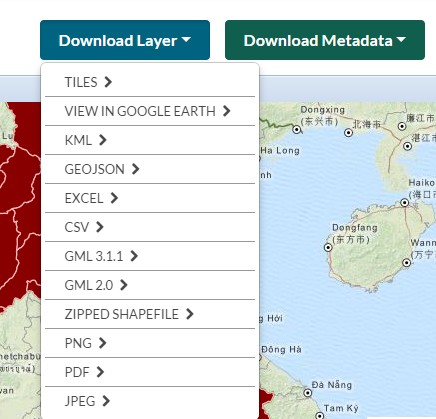
Upon uploading a vector or raster data, it is necessary enter metadata using a CSW interface. When a data layer is uploaded and visualized, two buttons titled "Download Layer" and "Download Metadata" are appeared providing access to geospatial data and metadata within the GeoNode. In this way, GeoNode allows users to import and export both data and metadata.
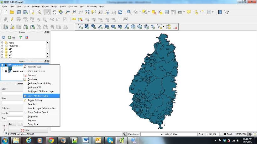
Linking Geonode With QGIS
It is possible to access data layers of GeoNode through Quantum GIS desktop application. Quantum GIS supports data populating from various data sources such as vector files, raster files, Postgres/PostGIS databases and WMS/WFS sources. Therefore, it is possible to define connection parameters of the GeoNode as a potential WMS/WFS source to QGIS and retrieve data from the same. This can be very useful feature as a user can get access to data available in the GeoNode directly from QGIS desktop application.
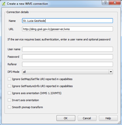
A) Making a WMS connection to GeoNode
If a GeoNode is connected as a WMS source, feature data are not available for analysis. In this case data is loaded as an image file to QGIS. Steps necessary for making a WMS connection to GeoNode are as follows.
1) Click on "Add WMS Layer" icon
![]()
2) Create a new WMS Connection to your GeoNode by define the WMS URL
3) Connecting to WMS Source
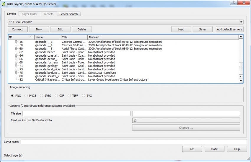
Successful completion of above steps will enable a user to connect to the WMS Server and the user can view the available layers in GeoNode.
|
Note |
|
The above steps will ensure the accessibility to unrestricted data layers. In other words, data layers where permissions set to "Share with Anyone" would be accessible in this manner. |
| In order to access the restricted data layers, it is required to provide the login credentials (username/password) of the system (GeoNode). |
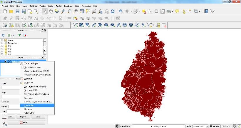
Populating data to QGIS (WMS)
Data layers can be added to QGIS through "Add" button in the Map View. The data layers are added as a WMS and they are loaded to QGIS as images and attribute data are not available.
B) Making a WFS connection to GeoNode
If a GeoNode is connected as a WFS source, attribute data is also loaded and various GIS analysis can be performed. In this case, data is loaded in GML format. WFS layers can be added by clicking on "Add WFS Layer" icon. A valid username and password will be required to access data layers with restricted access.
![]()
Populating data to QGIS (WFS)
If a dataset is opened as WFS, then it will be possible to see the attribute data enabling data analysis, which is not possible in case of WMS.
LIMITATIONS OF GEONODE
GeoNode provides limited opportunities for customization. GeoNode is also not suitable for datasets requiring frequent updating such as rainfall, as it will require produce new shape file for each updating. In such cases, it is better to develop independent system by integrating the core tools such as Geoserver, Open Layers, GeeoEXT, PostgreSQL/ PostGIS etc. In this way, the developer would have more flexibility of designing his own architecture to address certain needs. . In order to develop such a system, one should have good programming skills as well as through knowledge in GIS.
CONCLUSIONS
- GeoNode provides a user friendly framework for sharing geo-spatial data;
- It facilitates basic GIS analysis capabilities;
- In case of developing customized applications, programming skills are required.
KEYWORDS
GeoNode, QGIS, WMS, WFS, GeoServer, Open Layers, PostgreSQL/ PostGIS, GeoEXT