

Generally specific design measures for flood hazard are not explicitly considered in the structural design of typical buildings. The simplest way to reduce the hazard consequences is to avoid developing in the hazard prone areas. However this is not always possible, so risk reduction and mitigation measures may be required to lessen the severity of disasters due to flood hazard.
This use case presents a systematic approach to evaluate appropriate structural as well as non-structural measures where required and that can be applied to critical infrastructure to reduce the impact of the flood hazard while considering the flood hazard and risk factors .
Most measures to protect the buildings from flood hazard can be classified into three categories: a) Measures to protect the building site/area through blocking of water, drainage improvement or building water retention zones, b) Elevate the buildings, protect the buildings from strong water currents, debris flow, flotation and basement inundation by flood proofing and water resistant material, c) Install proper early warning systems and provide "safe house" within the buildings (Upper floors, etc.) and exit mechanism for rescue with boats, etc.
Keywords:
Flood mitigation, elevation, flood proofing
| Before you start: | Use case Location: | Uses GIS data: | Authors: |
|---|---|---|---|
|
Section 3.1.1 Buildings should be read before this use case. Building Codes and Regulations in OECS Countries |
OECS member countries | No | Naveed Anwar |
Introduction:
Flooding in OECS member countries is primarily caused due to tropical storms and hurricanes. Tropical storms and hurricanes cause storm surges in coastal areas as well as create heavy rainfall which causes inland flooding. Since, OECS member countries are prone to flood hazard, risk reduction and mitigation measures are required to reduce its impact. Causes of floods are natural phenomenon and it is difficult to control them on a local level but mitigation steps could be undertaken that minimises the level of damage to people and to the buildings.
The flood hazard may not have a devastating effects on most building structures built using water resistant materials, such as concrete, steel or seasoned timber, with basic flood management systems and standards prevalent in the OECS countries. The flood hazard however, disrupt the serviceability and operation of the buildings if the water depth is large to impeded access to the buildings. Flash floods, or wave surges near the coasts may submerge low-lying buildings, basements or areas without much waving leading to potential risks to life and extensive damage.
As this use case is specifically developed for buildings part of the critical infrastructure, the main concern is continued operations during floods, and preventing damage to sensitive and critical assets within the buildings. However, it is very important to note that even if the building itself is protected from flood damage, but the access to the building is blocked by flood water, the critical functioning of the building may be hampered, and the occupants may be stuck until rescue is carried out. It is therefore important to consider flood hazard while locating buildings of critical infrastructure or plan for their shut down during flooding with alternate arrangements.
It is important to relate the mitigation measures with the following flood risk factors which effect the scale and severity of disaster:
- the source and type of flooding
- the depth and velocity of flood water
- the duration and frequency of flooding
- the rate of rise of flood water and expected level (service level; design level and extreme event flood)
- the presence or absence of debris in the flood water
- the degree to which people and/or assets are exposed to the flood water
- the extent and vulnerability of the people and properties affected
It should be also considered that climate change predictions continue to develop and that these may have significant impacts on previous flood risk assessments. The Flood Map does not include the predicted effects of climate change.
Objectives:
The objectives of this use case is to describe the process to evaluate the structural mitigation measures that could be applied for the protection of critical infrastructure buildings against flooding These could be the measures to strengthen the construction itself (retrofitting, flood proofing), or could be measured that are carried out in the direct surrounding of the buildings (drainage, floodwalls, etc.). The process of analyzing which method would apply in which case is also illustrated with the examples of good practices.
Flowchart:
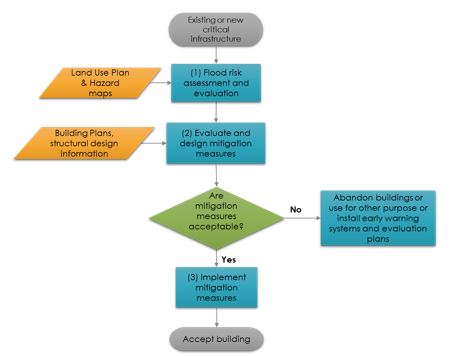
Figure 1: Overall process for evaluation of relevant structural mitigation measures for flood
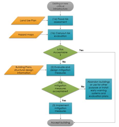
Figure 2: Detailed process for evaluation of relevant structural mitigation measures for flood
Problems definition and specifications:
As OECS countries are vulnerable to numerous natural disasters arising from meteorological events (high wind, excess rainfall, hurricanes, and drought). The procedures and consideration for protecting the buildings that belongs to critical infrastructures and facilities from the consequences of flood hazard are required. The main focus is on analysing structural measures that can be carried and around and within building.
Data requirements:
Following data may be required:
- Flood hazard maps
- Land use plans
- Building plans, and structural design information
Analysis steps:
General Application
These analysis steps can be applied equally to both existing and new critical infrastructure.
- Flood risk assessment and evaluation
- Flood risk assessment
The first step before identifying the relevant mitigation strategy is to evaluate the risk and vulnerability of the site and building to flood. The land use plan can be studied at this preliminary stage which will help in identifying the geographical context of the critical infrastructure. The aim of land use plan for managing flood risk through the planning system is to avoid inappropriate development in flood risk areas. The nature of flood risk, spatial distribution of flood risk; climate change impacts, and the degree of vulnerability of different types of development should be considered at this point.
For new construction, if the site lies in the flood plain and there is considerable risk to the building, it is best to relocate outside the flood plain, or protect the site through structural or non-structural measures. Special consideration should be given to the buildings under the critical infrastructure category, as it directly reduces the risk.
- Flood risk evaluation
Probability of occurrence and consequences are the two components for evaluating flood risk. Scale and severity of the consequences in case of flooding can be evaluated through several factors including source, depth and velocity, expected level, and duration of flooding.
For definition of expected flood levels, please refer to use case 2.3. Guidelines for incorporating landslide and flood hazards in building constructions.
- Evaluate mitigation and design measures
Based on the risk assessment and the inspection of the building, relevant mitigation measures can be evaluated.
|
Primary Flood Source |
Flood risk factors |
Evaluation Criteria |
Structural Mitigation Measures |
|
Flash Floods |
For design level flood |
Ensure structural integrity is maintained Floatation is prevented |
|
|
Back water flooding |
For service level flood |
Ensure living and critical service level are not inundated, building to remain operational Floatation, seepage is prevented |
|
|
|
For design level flood |
Ensure building safety, nominal disruption of operations, prevent critical services from disruption |
|
|
|
For extreme level flood |
Ensure building safety, prevent floatation, access to safe zones, provide escape mechanism |
|
|
Sea-surge and wave based coastal flood |
Water flow |
Ensure structural integrity is maintained Floatation is prevented |
|
|
Rain based flash flood |
Velocity and Depth |
Low velocity <less than 3 m/sec> low water depth < 1m |
|
|
High velocity, low water depth, velocity > 3 m/sec |
|
||
|
High velocity (> 3 m /sec), high water depth (> 1 m) |
(Use back water flooding process) |
||
|
Low velocity, high water depth |
(Use back water flooding process) |
Table 1: Primary Flood Source, Expected Flood Level and Structural Mitigation Measures
For the building specific measures, it is important to consider the historical information on the level and the velocity of the flood, and then select appropriate structural measures.
Flood resistance and flood resilience may need to be incorporated into the design of buildings and other infrastructure behind flood defence systems. Other structural measures that can implemented to reducing the flood hazard are:
- Changing Elevation: Elevating the existing structure on fill or foundation elements such as solid perimeter walls, piers, posts, columns, or pilings. The structure is raised so that the lowest floor is at or above the design flood elevation. Though elevated structures may provide increased protection from flood waters other hazards such as wind forces on wall and roof systems, additional loading on existing footings should be considered.
- Dry Flood proofing: Strengthening the existing foundations, floors, and walls to withstand the force of the flood while making the structure watertight. The watertight impervious membrane sealant can include wall coatings, waterproofing compounds, impermeable sheeting, and supplemental impermeable wall systems such as cast in-place concrete. The expected duration of flooding is critical in deciding the type of sealant to be used as the seepage may increase over time, rendering flood proofing ineffective.
- Water Flood proofing: Making utilities, and structural components flood and water resistant during the periods of flooding within the structure. In this structure is modified so that the floodwater enters in such a way that the damage to the structure and its contents is minimized. Wet flood proofing can be used when other mitigation measures may be technically infeasible or are costly.
- Floodwalls/Levees: Constructing floodwalls or levees around the structure. This involves construction of a barrier between the structure and the source of flooding. The floodwalls and levees can be constructed to any height, but are usually limited to 4 feet for floodwalls and 6 feet for levees due to cost, aesthetics, access, water pressure, and space.
- Implementation of structural mitigation measures
If the evaluated mitigation measures will be acceptable, the next step will be implementation. Typically, most structures designed for wind and earthquake may have sufficient in-build capacity and resilience for slow water speed and low water death. For fast current and high water depth, special structural evaluation of the building may be needed. For new buildings, this may mean to add additional reinforcement, increased foundation depth, or improved structural connections. For existing buildings, this may mean some retrofitting to improve the structural integrity, or to use "weal" blow out panels on walls to reduce the water pressure
Flood risk to people and property associated with such process can be managed but it can never be completely removed; a residual risk will remain after flood management or mitigation measures have been put in place. It can be the failure of flood management infrastructure such as a breach of a raised flood defense, blockage of a surface water conveyance system, or failure of a pumped drainage system; or a severe flood event that exceeds a flood management design standard.
The safe evacuation plan are also required besides structural mitigation measure to reduce the vulnerability and these plans depends on: [1]
- The type of flood risk, and the extent to which advance warning can be given in a flood event;
- The number of people that would require evacuation from the area potentially at risk;
- The adequacy of both evacuation routes and identified places that people could be evacuated to (and taking into account the length of time that the evacuation may need to last); and
- Sufficiently detailed and up to date evacuation plans being in place for the locality that address these and related issues.
Example Application
Flood Mitigation Measures at Asian Institute of Technology, Thailand
Asian Institute of Technology (AIT) located in Pathum Thani province of Thailand is a residential campus with approximately 3,000 people on-campus. The campus is considerably at a lower elevation compared to the adjacent university campus. During the flooding that affected 65 provinces of Thailand, the AIT campus was also inundated with approximately three meters of flood water. The ground floor of the buildings in AIT were completely inundated and the facilities on campus were extensively damaged. In order to reduce the devastation of any future flooding following measures were undertaken:
- Moving all the essential services/ facilities from ground floor to upper floor.
- Using materials in the ground floor that would result in minimal replacement cost.
- In some buildings and based on necessity, the ground floors have been completely abandoned
- Construction of dykes along the perimeter of the campus, having an approximate height of four meters
- Review of the existing pump system to drain water out of the campus
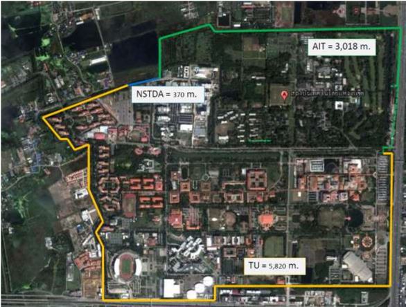
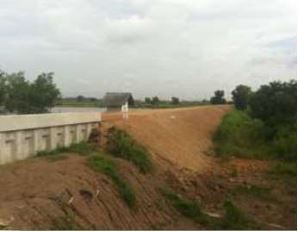
Figure 5: Imagery showing the joint dyke construction by Asian Institute of Technology, Thailand, Science Park, and Thamasat University
 |
 |
Figure 6: Dykes around AIT Campus
Flood Wall at Iowa State University [2]
The Maple-Willow-Larch Resident Halls, located on the campus of Iowa State University (ISU), provide housing for nearly 1,600 students. On July 9, 1993, floodwaters entered the complex at various locations and caused extensive damages to the Commons and ground floors of each building, during the 1993 floods, floodwaters reached up to 5 feet in the lower level of the Commons.
To minimize devastation by any future flooding at the complex, an assessment was conducted to determine the best flood proofing plan. Based on the result of the assessment, it was decided to construct flood walls around the perimeter of the campus.
Ranging in height from zero to 4 1/2 feet, the flood wall surrounds the complex at the low-lying areas, is buried in the ground, and is designed to withstand floodwaters 18 inches higher than those of the 1993 floods. It consists of a combination of earthen berm and concrete wall system. There are six gaps in the wall that allow natural walkways. In a flood, water is stopped from entering the complex by gates placed in the walkways of the concrete wall. Floodwater pushing against the gate helps seal the rubber to the concrete and steel, further reinforcing the flood wall.
The flood wall and surrounding earth, built up to keep floodwaters out, also traps rainwater inside the area. During normal amounts of rain, a pump system senses rising water levels, flood stage or lower, and pumps the water out of the area. During 3 days of heavy rainfall in August 2010, low-lying areas flooded again as the Skunk River and Squaw Creek exceeded capacity and in some areas surpassed record flood levels of 1993. Extensive flooding occurred throughout the city, as well as other buildings and facilities on the ISU campus, but floodwaters did not breach the flood wall at the Maple-Willow Larch complex.
Canaries Primary School and Bexon Primary school
Canaries Primary school and Bexon Primary School were effected by Tomas Hurricane in November, 2010.
Based on the case studies, following structural mitigation measures should be considered for school buildings in OECS countries:
- Need to increase water storage capacity in schools. In the aftermath of Hurricane Tomas, a 1000 gallon water tank was made available to every school. At this point in time every school has a .minimum capacity of 2000 gallons.[3]
- Application of flood mitigation measures e.g. maintenance of drains around schools. Pumping system can be installed on campus to protect the schools from heavy rains
- Rebuilding of retaining walls or dykes, installation of flood gates
- Revisiting the design of school buildings to reduce damage to school property and to mitigate against heavy flooding. Location of classrooms in schools in flood prone areas needs to be revisited. Consideration should be given to the use of the ground floor for co- curricular activities whilst the upper floors can be used to conduct classroom instruction.
- Need to design evacuation plans ad safe exists. Every school should have regular evacuation drills to ensure the development and implementation of a school disaster management plan.
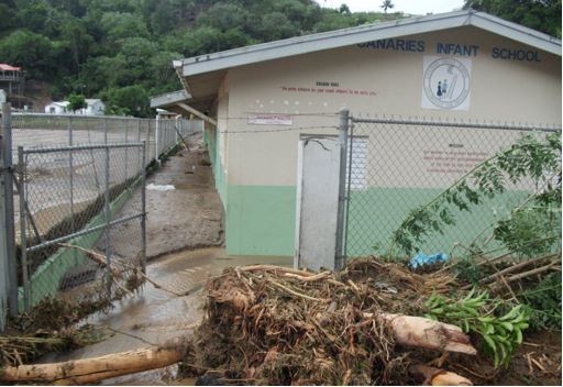
Figure 7: Canaries infant school (Mud covering the yard after Tomas Hurricane)
Conclusions:
The buildings categorized as part of the critical and essential infrastructure need to be protected against flood hazard which based on the flood risk level defined in the use case. Flood are natural and it is difficult to prevent them but mitigation steps could be undertaken that minimises the level of damage to the occupants, assets, and to the buildings themselves, and to reduce down-time for the operational and service duration. To make decisions regarding the flood risk mitigation, an assessment of the flood hazard should be conducted. This involves incorporating information using flood hazard maps, historical flood data, and land use plans.
Appropriate structural mitigation measures should be selected through evaluation process to increase flood resistance and resilience of critical infrastructure buildings and their surroundings.
References:
[1] Planning Policy Statement 25: Development and Flood Risk Practice Guide UK, December 2009.
[2] Mitigation Best Practices, FEMA, August 10, 2011
[3] After Action Review of Saint Lucia"™s Response to Hurricane Tomas of 2010, NIC Conference Room, Castries Waterfront, Saint Lucia 25 & 26 July, 2011
Last update: 02-04-2016