

Introduction
The location of facilities like schools and hospitals is a strategic spatial planning decision, geared to the spatial allocation of scarce land resources for the development of a public facility. Its strategic importance lies in its long term impact, not only on the facility itself, its viability and its use, but also on its surroundings and the urban system as a whole. Facility location is a typical planning problem that needs to be looked at in an integrated process. Key issues to be addressed in this process are the demand for the service the facility offers (over space), its characteristics (functions, area requirement etc. ) and the suitability of possible locations. However all of these issues need to be looked at in integration with broader issues regarding land and infrastructure development which adds complexity to the planning problem.
Objective
Provide a basic methodology description for facility location to be used by planners in their day-to-day work, when carrying out the planning themselves, when preparing for terms of reference of advisory services and when supervising such services
Users
Planners working at different kinds of facility location.
Methodology
Scientifically, facility location itself is studied in fields as diverse as spatial planning, geography and operations research and there is a plethora of methods of increasing complexity that address facility location problems. What we present in this methodology book is a basic and practical approach to facility location that is inspired by spatial planning and geographical methods, puts emphasis on the use of hazard and risk information and can be used by local stakeholders and consultants. It is a deterministic and deductive approach, that allows for the evaluation of various alternatives (on the basis of the opinions of stakeholders), rather than a more formal and mechanistic optimisation approach that is prevalent in operations research.
It is important that hazard and risk information are taken into consideration when planning the location of public facilities in hazard prone areas. The reasons for this is are essentially three-fold. Firstly, these public facilities are intensively used and there are often many people present that could be under threat in case of too high levels of risk. Secondly, all these facilities are important for the functioning of society and their damage/failure will have repercussions for the facility to be able to keep functioning. Thirdly, facilities like hospitals are extremely important in a crisis situation, where it is of utmost important that they can continue to function without problems. Therefore, for this particular facility, location in an area with very low risk is important. This may also be the case for schools, which may function as temporary shelters during disasters.
In order for a proper location to be chosen in the end therefore, many aspects need to be considered, the most important ones are discussed in the section below. A methodology is proposed that guides the planner through a step-by-step approach.
The following phases are identified and shown in the flowchart. By clicking on the items in the flowchart more detailed steps are shown within each phase when applicable.
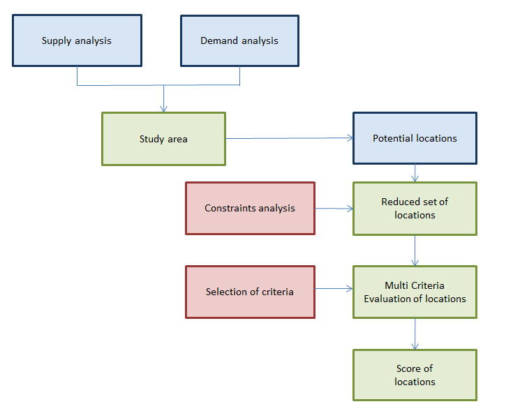
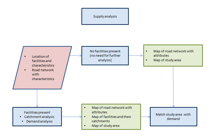
Supply analysis
In this phase we are looking at the supply characteristics of the existing facilities (if applicable) and how these are distributed over space. We are also examining the existence and quality of the critical infrastructure networks over space, as the availability of those networks is crucial for the proper access to and functioning of the facility. In this phase we answer the following questions:
- What is the distribution of current facilities and what are their characteristics?
- What is the layout of the road network, what is its quality, are there issues with road congestion?
- Provide an overview of all other critical infrastructure networks that are required at the location (water supply, electricity, sewerage, telecommunication)
In the simplest situation, we would be planning a new facility in a certain geographical area like a town or a village, where such facility does not exist, or where it needs to be relocated. In such situation there is no competition between facilities and we can assume that all potential users of the service in the area will use our planned facility only. We can then assume the whole study area to be the search area for the location. Therefore all demand is also served by the new facility.
In the case where already one or more other facilities exist, our new facility may be in competition with the existing facilities. This provides for a more complex situation, but there are some spatial analytical methods available that can help us analyse this, after we have looked at the demand.
Demand analysis
In this phase we are evaluating the demand for the facility. Who are the intended users of the facility and where do they live? What are the functional requirements of the facility and how much space do we anticipate is needed? In this phase we answer the following questions:
- What is the demand for the facility in the area? And where is it located?
- How do we express demand? (E.g. in the case of a primary school it would be the nr. of school going children by age group)
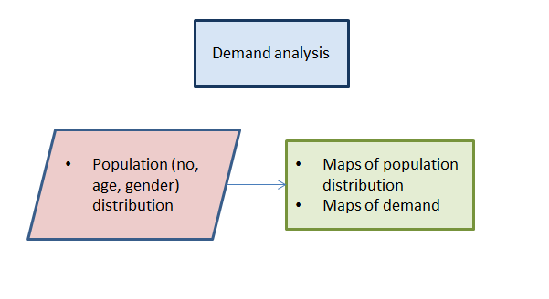
In the demand analysis phase therefore we are asking ourselves the question: Where is the demand for the new service located. The basis for answering this question can be provided by looking at the spread of population over space. This would start with a basic map of population, typically from a census survey, preferably at the highest possible level of aggregation. In most Caribbean countries this would be the level of the enumeration block, which typically consists of 100 or so households. In case the facility that we are providing is not directed at all people, but at a specific group, we would need to focus on information of that particular group. E.g. in the planning of a primary school, we would need to know how many children of primary school going age (6-12) are living in our study area. Our demand map would then essentially be a polygon map of enumeration blocks, where the number of school going children is mapped.
Now that we know where our demand is located we are going to match it with the supply.
Matching demand and supply
On the basis of the supply analysis, we have walked one of two possible routes. In the first route, we plan 1 facility and there are no competing facilities. This analysis provides us with our study area. We can now overlay this with our demand map, to determine the demand of our study area. If this is the done, we can move on to the phase of selection of potential locations.
In the case of the second route, where more facilities are present, we may carry out a catchment analysis at this point. In this analysis, we determine which areas are served by which particular facility. In its most common form we assume here that, service quality being equal in the different service facilities, people make use of the nearest facility. This nearness can be measured as distance or travel time over the transport network, which is usually preferred. In addition, we would normally put a resource constraint on the facility, typically the capacity of a school or hospital, to ensure that the catchment areas that we generate are not generating more demand than the facility can handle.
As a result of such analysis we get an overview of where, spatially, there is a gap in supply and demand. This would then become our study area in which the facility is to be located.
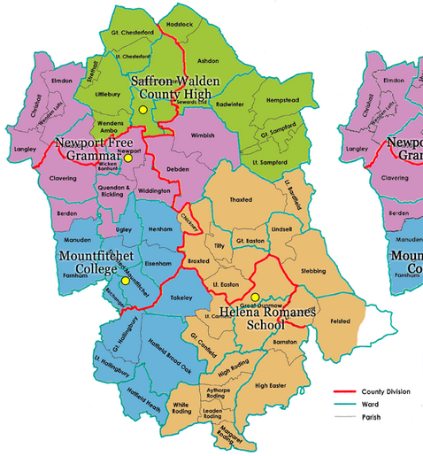
Fig: example of a catchment analysis map
Identification of potential locations
In this phase we are generating an unbiased overview of all potential locations. We are not going to exclude locations at this stage other than on the basis of the size of the location. In order to estimate the plot size needed, we need to look at the functional requirements of the facility.
Using facility standards of the country concerned, we can calculate on the basis of the amount of people served what the area requirements of the facility are. In the educational sector these would be based on no. of classrooms required, size of classrooms, size of general facilities, sports facilities, playgrounds, parking locations, bicycle sheds, etc. etc. Estimation should be made of the total area that is needed for the facility, as this determines the plot size that is needed. Both the map of spatial demand and the plot size are inputs in the next part of the process.
To identify potential locations, we need some further information on the area and its land use. In case land use maps are available, these would be suited to determine potential locations, possibly in combination with aerial photographs or google earth images.
Evaluation of locations
The evaluation of locations is geared to the reduction of the set of potential locations to one - or at most a limited - number of locations, on the basis of which a final choice can be made in the political arena. This evaluation process takes place in two steps.
First we identify so called hard constraints; these are constraints that are so important that no development can be allowed at such locations. Hard constraints are generally formed by unacceptable levels of risk for flooding, e.g. for areas that are too close to the coast or areas that are exposed to river flooding. Here we should focus not only on the location itself, but also on the road infrastructure that provides access and egress, the use of which may not be compromised in the case of evacuation or shelter. Important transport axes may therefore also not be located in hazard prone areas.
In addition there are natural hazard constraints in terms of not allowing building in landslide prone areas. Also there may be reasons not to build in certain locations where there is a high possibility of wind related disaster.
In addition to the natural hazard hard constraints there may also be other hard constraints related to the conservation of the natural environment, where developments are not allowed in or close to a protected area, or e.g. in close proximity of industrial complexes that can create a potential man-made risk or unhealthy situations.
These constraints - and also the choice whether they are hard constraints or soft constraints - are obviously context dependent and would be regulated in the respective planning framework of the Caribbean country and local level land use planning and development ordinances where applicable. In many Caribbean countries however, and in the absence of a formal local land use planning tradition, the evaluation of site locations is part of the building permit procedure. This procedure however is based on an individual assessment of an intended development location, rather than on a holistic planning assessment of facilities in an entire area, which is the purpose here.
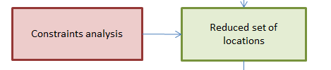
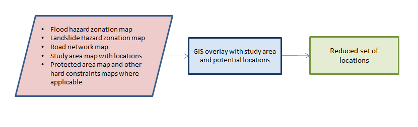
As a result of the process of identifying the hard constraints, we create a map in which the number of potential locations in the study area is reduced, thereby reducing the choice set during the next step.
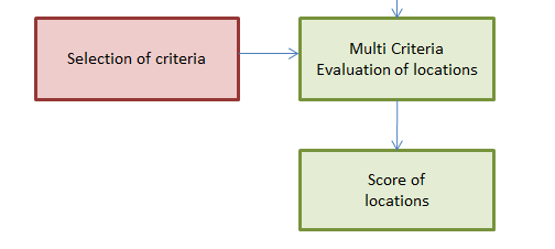
In this next step we are going to continue the evaluation on the basis of the soft constraints, using a Spatial Multi Criteria Evaluation procedure. We refer to the section on Spatial Multi Criteria Evaluation elsewhere in the handbook.
There are potentially a lot of soft constraints, these are factors that are constraining the possibility to develop a particular site, but they are not absolute, like the hard constraints. The selection of soft constraints will be locality and context dependent, but typically these constraints would include accessibility of the site, costs of acquisition, costs of modification of terrain, building cost, suitability of the environment etc. These constraints will become the criteria in a multi-criteria evaluation of the potential sites. It is advised to take the most important and only locally relevant criteria into consideration, there is no need to make the MCA needlessly extensive, as this will make the analysis more complex and less transparent.
Examples of evaluation criteria are:
- Level of hazard/Risk of location
- Level of hazard/Risk of location of access/egress system
- Capacity of existing infrastructure, need for capacity improvement
- Cost of connecting to infrastructure
- Traffic and Transport situation - closeness to main roads
- Access to the facility of the majority of the target population within a certain travel time
- Land value
- Cost of construction and development of site
- Etc. etc.
This phase allows for the involvement of stakeholders in the decision on which criteria to include and in the weighting of the criteria scores. It also allows for the development of alternatives in an iterative way. One can imagine that certain sites get a low score in a first iteration, because of a medium hazard or risk level, however, when mitigation alternatives are considered that can reduce this level, the score would become higher and the site might compete again with other sites that have other disadvantages. To perform this analysis in a meaningful way those involved should have a thorough understanding of the area, the characteristics of the various sites and the possibilities to reduce risk through mitigation. (see also elsewhere in the handbook - sections - -- )
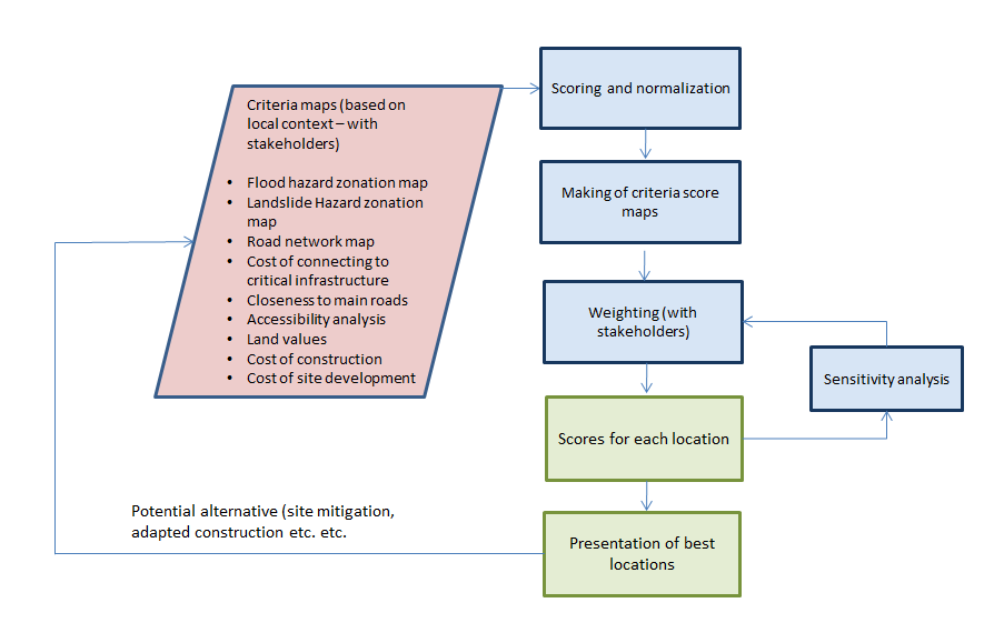
It is possible to consider a sensitivity analysis as part of the approach, to test the robustness of the assessment. If suitability scores remain relatively unchanged even after alterations, then this implies a robust assessment. There are different ways to carry out sensitivity analysis, as discussed in section …. of the handbook. As a result of the sensitivity analysis it is clear to what extent the suitability scores are sensitive to the values of the different criteria maps and the weights obtained. This can prompt a more detailed analysis of input data, or a different setting of weights. For example, it could be that the suitability score of a location is very sensitive to its being just inside, or just outside a low risk area. If this is the case, the quality of the risk map should be verified to ensure that the limits between the zones are real.
Conclusion
The facility location problem is quite complex and there are many considerations involved. The described methodology provides a common approach to tackling this problem. The strength of it is the relatively transparent and open way in which alternative locations are generated and evaluated. Being a complex spatial decision problem, the quality of the alternatives that are generated is too a large extent dependent on the quality of the spatial data that is used in the process. Users should be critical towards this quality. It is better to exclude a criterion if there are doubts about the underlying quality of the data, rather than include it and create a low quality analysis result.