

Author: Michiel Damen
This chapter of the Caribbean Handbook of Risk Management covers essential aspects of the management of geospatial data.
One of the defining features of geo-information science is its ability to combine spatially referenced data. A frequently occurring issue is the need to use spatial data from different sources that have different spatial reference systems. The map projection system varies from country to country in the Caribbean region.
Chapter 6.2 deals with the basics of map projections, datum, etc. and provides some guidelines for adopting a suitable projection system for analyzing and storing the available spatial data. Explained are the principles of the geoid as a reference system for heights and the ellipsoid as a mathematical model of the earth as the basis of the geographical datum. Also map projections are dealt with, including map projections and datum used in the West Indies.
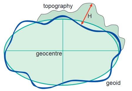
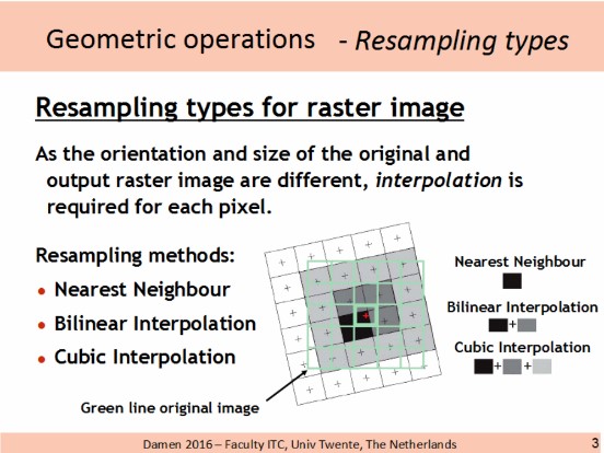
Figure 1(LEFT) Height of topography above ellipsoid (h) and geoid (H)
Figure 2 (RIGHT) Presentation slide Sub Chapter 6.2 on different types of gemetric transformations. M. Damen, ITC 2016
Chapter 6.3 deals with so called Data Homogenization. This is the process of bringing all data into a common geospatial framework to ensure consistency of data, integrity of analysis and validity of results. In a geospatial database, data are used from various sources; data that were captured using different technologies; and data published in different coordinate systems. All of which must be harmonized before using in a GIS. This can be vector data but also raster data from satellite images or a digital elevation model; also old scanned topographical paper maps with many unknown distortions can be used for the study of historic changes.
An important part of data homogenization is the process of geo-referencing and geo-coding of all data used in a geospatial database. All datasets have to be referenced to the same spatial coordinate system and correctly overlay each other. This alignment of coordinate systems is referred to as geo-referencing.
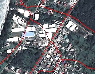
Figure 3: Mismatch of digitized roads on top of Pleiades satellite image - Dominica 2014.
The term geo-coding is used when not only the coordinate system, but the whole row-column system of for instance a satellite image or a scanned topographical map is transformed. For vector data geo-referencing is sufficient in most cases. The Use Case Book Chapter 9.1 on Homogenization of base data gives three very illustrative examples of the removal of horizontal data shifts between satellite raster data and vector base data of the Caribbean islands.
Finally some suitable software tools are suggested - including open source - to geo-reference and geo-code all raster and vector data to be used, including the geographic re-projection from one datum to the other.
Chapter 6.4 deals with Accuracy and precision of geospatial data. When a new dataset is uploaded in a geospatial database, the software imports not only the data, but also the error that the data contains. One should be aware of this and understand the limitations of the data being used.
Accuracy is generally considered to be the degree of closeness of an entity to its actual/true value. In a GIS one must consider all aspects of accuracy including its position accuracy; temporal aspects; thematic aspects and completeness.
While accuracy refers only to how close the measurement is to the true value, is precision related to resolution and variation. In a way this is a measure of the spatial generalization of the data. In vector data, this may be considered a function of the scalability and preference of the data. With raster data, the resolution is usually understood to be the grid size of the data, with the value representing the thematic information of interest. In terrain models these values can represent elevations at the top of features, such as in a digital surface model (DSM), and values on the bare earth or digital terrain model (DTM).
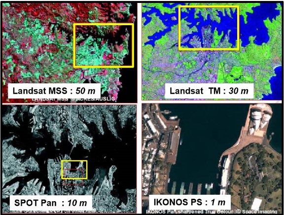
Figure 4: Example of spatial resolution of an area, acquired by different types of satellite images.
Chapter 6.5 gives more information about meta-data and why this is essential information to better understand and value the data we work with. It is "data about data".
Chapter 6.6 deals with GIS data formats. A GIS data format is a standard of encoding geographical information into a file. There exist two basic formats used to represent GIS data these are " vector" and " raster" types. Both formats are used to represent our perception of reality, each having some advantages and disadvantages over the other. It is important to note that many types of GIS software will allow working with both data formats; however some only allow analysis to be done with raster. In the chapter are both data formats discussed.

Figure 5: Pixels of Landsat 8 panchromatic image; Northeast coast St. Lucia. Different shades of white indicate breaking waves at the cliffs.
EU INSPIRE Initiative
INSPIRE is an initiative of the European Union to harmonize the management of spatial information between the member states. It has set standards for spatial data management and Spatial Data INfrastructure (SDI) that are now widely followed - also outside the EU . The INSPIRE directive aims to create a harmonized spatial data infrastructure with the aim to assist in policy-making across boundaries. Therefore the spatial information considered under the directive is extensive and includes a great variety of topical and technical themes, including natural hazards and disaster risk.
INSPIRE seeks to " enable the sharing of environmental spatial information among public sector organisations and better facilitate public access to spatial information across Europe" . For this a Geoportal has been built, through which the member states can search, discover and download geographic information, provided by European governmental, commercial, and non-commercial organizations. It includes a Resource browser, Validator, as well as a Metadata editor.

Figure 6: Click on image to start the INSPIRE Video
Key factors which are relevant to cross boundary integration of geospatial data include the development of an infrastructure for spatial information in the European Community - in DIRECTIVE 2007/2/EC OF THE EUROPEAN PARLIAMENT AND OF THE COUNCIL - for the following purposes:
- Coordination between the users and providers of the information
- Integrated environmental policy-making, taking a wider scope of local and regional boundaries
- Address issues in availability, quality, organisation, accessibility and sharing of spatial information
- Use of geospatial data to assist policy-making in relation to policies and activities that may have a direct or indirect impact on the environment
- Manage the storage, security and sharing of data across different levels of stakeholders
- Directives should not affect the existence or ownership of intellectual property rights
- Promote and facilitate the use of geospatial standards including metadata
- Collaboration with 3rd party geospatial stakeholders, including data owners
- Data should be collected only once and kept where it can be maintained most effectively
- It should be possible to combine seamless spatial information from different sources across Europe and share it with many users and applications
- It should be possible for information collected at one level/scale to be shared with all levels/scales; detailed for thorough investigations, general for strategic purposes
- Geographic information needed for good governance at all levels should be readily and transparently available
- Easy to find what geographic information is available, how it can be used to meet a particular need, and under which conditions it can be acquired and used.
Remarks
For small islands, the need for cross boundary geospatial protocols may be unessential. However, the concept offers other improvements in the way data is managed. It is less likely that geospatial decisions made on one Caribbean country would affect another, unless it involves the maritime administrative boundaries. As such, the real benefit of using an INSPIRE model is by way of resource sharing, especially as many small islands do not have the resources (human and financial capacities) to guide the collection and management of geospatial data. Having a Caribbean wide geospatial framework will facilitate a shared platform of standards, data collection, data sharing and analysis. The use of common standards ensures that data integration will be homogenised, to a common coordinate system and common standards of quality. The prospects of shared data collection will also assist in homogenization and perhaps lower acquisition costs. Data sharing and analysis will facilitate better integration of the Caribbean Islands towards increasing resilience while fostering better relations between the islands.