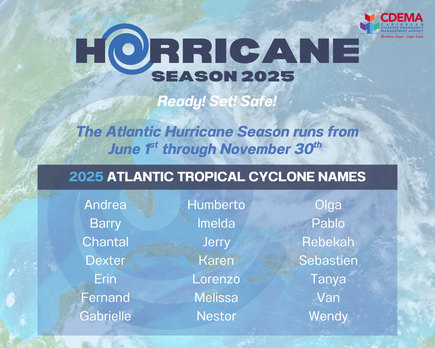
Hurricane Season 2025
2025 Atlantic Tropical Cyclone Names
A hurricane is a tropical cyclone (see below) in which the maximum average wind speed near a centre or eye exceeds 74 mph or 119 Km/h. The winds rotate in a counter-clockwise spiral around a region of low pressure. In the Atlantic and Eastern Pacific such systems are they are called HURRICANES. In the Western Pacific, including the Philippines - TYPHOONS, near Australia - WILLY WILLY and in the Indian Ocean - CYCLONES. The tropical cyclones are given names for easier identification and tracking.
Tropical cyclone is the generic term used by the World Meteorological Organisation to define weather systems developing over tropical or subtropical waters in which winds exceed 34 knots or 63 km/h. Tropical cyclones also have a definite organised surface circulation.
Four conditions are necessary for the development of a tropical cyclone:
-
A warm sea temperature in excess of 26 degrees Celsius or 79 degrees Fahrenheit.
-
High relative humidity (degree to which air is saturated by vapour).
-
Atmospheric instability.
-
A location of at least 4 - 5 latitude degrees from the Equator.
There are four phases of development which are linked to to the associated wind intensities:
Tropical Disturbance
A weather system which gives rise to a specific area of cloudiness with embedded showers and thunderstorms.
Tropical Depression
A tropical cyclone system with definite counter-clockwise wind circulation with maximum sustained winds of less than 38 mph (61 km/h). At this stage the system is given a number.
Tropical Storm
A tropical cyclone system, with maximum sustained surface winds greater than 38 mph (61 km/h), but less than 74 mph (119 km/h). At this stage the system is given a name.
Hurricane
A tropical cyclone with wind speed greater than 74 mph (119 km/h). The weather system is now better organised and the eye is well defined.
The Saffir Simpson Scale is used to classify Hurricanes according to intensity. In this scale, hurricanes are classified into one of five categories as shown below.
Saffir/Simpson Hurricane Scale
| CATEGORY | CENTRAL PRESSURE MEAN (millibars) | WINDS Mph (Km/H) | SURGE (ft) | DAMAGE | EXAMPLE OF A STORM |
| 1 | 980 or more | 74 - 95mph (119 - 151km/h) | 4-5 | Minimal | Lili 2002 |
| 2 | 965 - 979 | 96 - 110mph (152 - 176km/h) | 6-8 | Moderate | Isabel 2003 |
| 3 | 945 - 964 | 111-129mph (177 - 209km/h) | 9-12 | Extensive | Katrina 2005 |
| 4 | 920 - 944 | 130 - 156mph (210 - 248km/h) | 13-18 | Extreme | Charley 2004 |
| 5 | less than 920 | more than 157mph (248km/h) | more than 18 | Catastrophic | Gilbert 1988 |
Tropical cyclones are characterised by their destructive winds, storm surges and exceptional levels of rainfall which may cause flooding.
Destructive Winds
The strong winds generated by Tropical cyclones circulate clockwise in the Southern Hemisphere and counter clockwise in the Northern Hemisphere while spiraling inward and moving towards the cyclone centre. Winds speeds progressively increase towards the core. As the eye arrives, winds fall off to become almost calm but rise again just as quickly as the eye passes and are replaced by hurricane force winds from a direction nearly the reverse of those previously blowing.
Storm Surges
The rise in sea level above the normal tide. (See Table for Saffir-Simpson Scale). As the cyclone approaches the coast, the friction of strong on-shore winds on the sea surface, plus the "suction effect" of reduced atmospheric pressure, can pile up sea water along a coastline near a cyclone's landfall well above the predicted tide level.
Excessive Rainfall
The high humidity condenses into rain and giant cumulus clouds result in high precipitation rates when the cyclone reaches land. The rain rapidly saturates the ground and rapid run off will result in severe flooding.
Physical Damage
Structures will be damaged or destroyed by wind force, storm surges, landslides and flooding. Public utilities such as overhead power lines, water and gas distribution lines, bridges, culverts and drainage systems are also subject to severe damage. Fallen trees, wind driven rain and flying debris can also cause considerable damage.
Crops and Food Supplies
The combination of high winds and heavy rain and flooding can ruin crops and trees. Food stocks may be lost or contaminated and it is possible that food
shortages will occur.
Casualties and Public Health
There are relatively few deaths associated with the impact of high winds. However, storm surges may cause many deaths but usually few injuries among survivors. The threat to public health emerges in the aftermath of events when conditions such as water contamination or shortages, flooding and damage to sanitation facilities may favour the spread of diseases.
Lack of Communication
Communication may be severely disrupted as telephone lines, radio and television antennas and satellite disks are blown down. Roads and railway lines may be blocked by fallen trees or debris and aircraft movements are curtailed for hours after a cyclone.

Why are tropical cyclones named?
Tropical cyclones are named to provide ease of communication between forecasters and the general public regarding forecasts, watches, and warnings. Since the storms can often last a week or longer and that more than one can be occurring in the same basin at the same time, names can reduce the confusion about what storm is being described. According to Dunn and Miller (1960), the first use of a proper name for a tropical cyclone was by an Australian forecaster early in this century. He gave tropical cyclone names "after political figures whom he disliked. By properly naming a hurricane, the weatherman could publicly describe a politician (who perhaps was not too generous with weather-bureau appropriations) as 'causing great distress' or 'wandering aimlessly about the Pacific.'" (Perhaps this should be brought back into use ;-) During World War II, tropical cyclones were informally given women's names by US Army Air Corp and Navy meteorologists (after their girlfriends or wives) who were monitoring and forecasting tropical cyclones over the Pacific. From 1950 to 1952, tropical cyclones of the North Atlantic Ocean were identified by the phonetic alphabet (Able-Baker-Charlie-etc.), but in 1953 the US Weather Bureau switched to women's names. In 1979, the World Meteorological Organisation (WMO) and the US National Weather Service (NWS) switched to a list of names that also included men's names.
The Northeast Pacific basin tropical cyclones were named using women's names starting in 1959 for storms near Hawaii and in 1960 for the remainder of the Northeast Pacific basin. In 1978, both men's and women's names were utilized. The Northwest Pacific basin tropical cyclones were given women's names officially starting in 1945 and men's names were also included beginning in 1979. Beginning on 1 January 2000, tropical cyclones in the Northwest Pacific basin are being named from a new and very different list of names. The new names are Asian names and were contributed by all the nations and territories that are members of the WMO's Typhoon Committee. These newly selected names have two major differences from the rest of the world's tropical cyclone name rosters. One, the names by and large are not personal names.
(Messages issued by the authorities warning about the formation and development of tropical cyclones.) These are usually issued at 0600 AST, 1200 Noon, 1800 AST and 1200 midnight by the National Meteorological Service via the Electronic Media. (AST - Atlantic Standard Time is the same time zone as "Eastern Caribbean Time") Information Includes:
Name, Date and Time of Fix (reported location)
Location (relative distance from prominent place).
Coordinates (latitude and longitude).
Maximum winds.
Movement (direction and speed).
Forecast position.
Precautionary information.
Time of next issuance.
Types of Advisories include:
Tropical Depression Advisory
Provides information on the development and threat of a Tropical Depression which becomes a threat to land. The system is not named unless it is a Hurricane or Tropical Storm which has been down-graded to a Tropical Depression. Each new tropical depression is assigned a number, however.Tropical Storm Advisory
Issued when the wind speed of a tropical cyclone reaches 39 mph (63 km/h) or higher. Tropical Storms are given names.Hurricane Watch
Advisory issued for a particular area when conditions are favourable for the development of a hurricane. It does not necessarily mean that a hurricane is imminent. Hurricane watches will be issued when Hurricane conditions are possible along the coast within 48 hours (instead of 36 hours which was previously used).Hurricane Warning
Issued when hurricane conditions are expected to affect a particular area within 36 hours (instead of 24 hours).
On Hearing Advisory
Continue normal activities but stay tuned to radio and television for further messages.
Hurricane or Tropical Storm Watch
Review emergency preparedness requirements, especially family emergency plans.
Continue to listen to weather advisories on radio.
Be ready to take quick action in case of a Warning.
Establish contact points.
Hurricane or Tropical Storm Warning
Stay tuned to the radio for information.
Protect property and personal possessions (including important documents).
Place indoors, loose objects found in and around the yard.
Fill up car with gasoline.
Pick fruit and trim trees if near house.
Store water, food and essential medicines.
Feed animals and pets and move indoors or loose.
Know where you are going to shelter if the need arises.
After the Hurricane (or Tropical Storm)
Assist in search and rescue.
Seek medical attention for persons injured.
Clean up debris and effect temporary repairs.
Report damage to utilities.
Assist in road clearance.
Watch out for secondary hazards, fire, flooding, etc.
Assist in community response efforts.
Avoid sightseeing.
Co-operate with Damage Assessors.
Note: Additional precautions are available from the local National Disaster Office
On Hearing Advisory
- Continue normal activities but stay tuned to radio and television for further messages.
Hurricane or Tropical Storm Watch
- Review emergency preparedness requirements, especially family emergency plans.
- Continue to listen to weather advisories on radio.
- Be ready to take quick action in case of a Warning.
- Establish contact points.
Hurricane or Tropical Storm Warning
- Stay tuned to the radio for information.
- Protect property and personal possessions (including important documents).
- Place indoors, loose objects found in and around the yard.
- Fill up car with gasoline.
- Pick fruit and trim trees if near house.
- Store water, food and essential medicines.
- Feed animals and pets and move indoors or loose.
- Know where you are going to shelter if the need arises.
After the Hurricane (or Tropical Storm)
- Assist in search and rescue.
- Seek medical attention for persons injured.
- Clean up debris and effect temporary repairs.
- Report damage to utilities.
- Assist in road clearance.
- Watch out for secondary hazards, fire, flooding, etc.
- Assist in community response efforts.
- Avoid sightseeing.
- Co-operate with Damage Assessors.
Note: Additional precautions are available from the local National Disaster Office